Español:
La Estación del Norte fue construida por la Compañía de los Caminos de Hierro del Norte de España como estación término del FC del Norte, que une Madrid con la frontera francesa de Irún/Hendaya. Esta línea se desvía del que sería el trazado más directo por el puerto de Somosierra y pasa por Ávila, Medina del Campo, Valladolid, Burgos, Vitoria y San Sebastián.
También es conocida como Estación de Príncipe Pío por estar construida junto a la Montaña del Príncipe Pío. Este emplazamiento de la estación fue desde el primer momento fuente de discusiones, ya que al encontrarse entre el Río Manzanares y la Montaña del Príncipe Pío, quedaban muy limitadas las futuras ampliaciones de la estación. Otro de los argumentos utilizados en contra de esta localización fue que se encontraba muy alejada del centro urbano, por increíble que pueda parecer hoy.
El origen de la estación fue un sencillo embarcadero que comenzó a utilizarse en 1861 con la apertura al tráfico del tramo Madrid-El Escorial, ya que la inauguración de la línea completa no se produjo hasta 1864. La estación, tal y como la conocemos actualmente, es el resultado de varias ampliaciones y modificaciones.
Este primer embarcadero se quedó pequeño rápidamente ante el progresivo aumento del tráfico de viajeros y mercancías. Para solucionarlo, se construyó la estación de Imperial sobre la línea de contorno, que une la Estación del Norte con la de Atocha, para uso exclusivo de mercancías. Además, se aprobó un proyecto para la construcción de un nuevo edificio en el mismo emplazamiento que el anterior. El proyecto, realizado por ingenieros franceses, no llegó a realizarse en su totalidad.
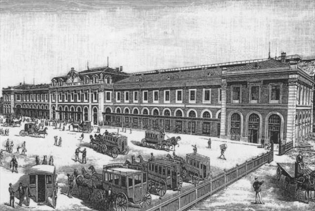
En 1882 se inauguró la nueva estación formada por un único edificio para viajeros y una marquesina metálica de 150 metros de longitud y 40 metros de ancho. Este edificio es el que actualmente se encuentra en el paseo de la Florida.
El segundo edificio de la estación, que se encuentra en la Cuesta de San Vicente y presenta dos torreones rematados en cúpula, no se construyó hasta 1928. A partir de ese momento, este edificio fue utilizado para las salidas y el antiguo para las llegadas.
Tras la Guerra Civil Española, la Compañía de los Caminos de Hierro del Norte quebró y la estación pasó a ser propiedad de la nueva compañía estatal que se creó: RENFE.
El principio del fin de la Estación del Norte llegó en 1967 con la apertura de la nueva Estación de Chamartín. Poco a poco, los servicios ferroviarios fueron pasando a la nueva estación hasta que el 30 de enero de 1993 salió el último tren de larga distancia de la Estación del Norte.
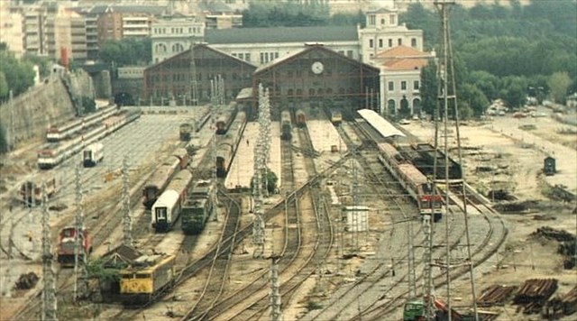
Entre 1993 y 1994 la estación permaneció cerrada para realizar una gran transformación y convertirla en un gran intercambiador de transporte. Las vías fueron modificadas para crear una estación de Cercanías de paso y aparecieron dos nuevas líneas de Metro (6 y 10) en su interior. Tanto para Metro como para Cercanías, la denominación de la estación es ahora Príncipe Pío.
Desde el año 2005 un centro comercial con un gran número de tiendas, restaurantes y cines está utilizando el edificio del paseo de la Florida y la antigua marquesina, junto con un nuevo edificio construido en la zona donde estaba la playa de vías. El edificio de la Cuesta de San Vicente está previsto que se convierta en un teatro, pero lo único cierto es que actualmente presenta un aspecto lamentable.
Al acercaros a por el caché podéis aprovechar para dar una vuelta por el interior para admirar el gran reloj de dos caras de la marquesina con sus 3,20 metros de diámetro o para imaginaros la estación cuando era usada por la gente que viajaba a Galicia, Asturias, Santander o el País Vasco y era la segunda estación más importante de Madrid tras la de Atocha.
El caché no está a la vista, pero con un poco de tacto es fácil de localizar. Su contenido inicial es un libro de registro, un lápiz y un dado para poder avanzar hasta la siguiente casilla del Geopoly.
¿Cómo llegar?:
 : Príncipe Pío


 : Príncipe Pío


 : 25, 33, 39, 41, 46, 62, 75, 138, C1, C2, 500. Nocturnos: N18, N19, N20.
English:
The North Station was built by the "Compañía de los Caminos de Hierro del Norte de España" as terminal station of the North Railway, connecting Madrid with the French border in Irun/Hendaye. This railway line deviates from the most direct route through the Port of Somosierra and passes through Avila, Medina del Campo, Valladolid, Burgos, Vitoria and San Sebastian.
It's also known as Principe Pio Station because it was built next to the Principe Pio Mountain. This location of the station was a source of discussion from the begining, because of it was between the Manzanares River and the Principe Pio Mountain and future expansions would be limited. Another of the arguments used against this location was that it was very far from the urban center, as incredible as it may seem today.
The origin of the station was a simple halt that began to be used in 1861 with the opening to traffic of the Madrid-El Escorial section, since the inauguration of the complete line did not take place until 1864. The station, as we know it today, is the result of several additions and modifications.
This first halt became small rapidly because of the progressive increasing in passengers traffic and freight. To solve this, the Imperial station was built on the contour line, which connects the North Station with the Atocha Station, for the exclusive use of freight. Moreover, a project to construct a new building on the same site as the old one was approved. The project, carried out by French engineers, was never completed in its entirety.
The new station, consists of a single building for passengers and a metal canopy of about 150 meters long and 40 meters wide, was inagurated in 1882. This building is currently in the Paseo de la Florida.
The second building of the station wasn't built until 1928. It's in the Cuesta de San Vicente and has two towers topped with cupola. From that moment, this building was used for departures and the former one, for arrivals.
After the Spanish Civil War, the "Compañía de los Caminos de Hierro del Norte" went bankrupt and the station became the property of the new state company that was created: RENFE.
The beginning of the end of the North Station came in 1967 with the opening of the new Chamartin Station. Gradually, train services were moved to the new station. The last long distance train left from the North Station on January 30, 1993.
Between 1993 and 1994, the station remained closed to carry out a major transformation and to become a transportation hub. The tracks were altered to establish a short distance (Cercanías) station and two new Metro lines (6 and 10) appeared inside the station. Both for Metro and Cercanías, the name of the station is now Principe Pio.
Since 2005 a shopping center with a large number of shops, restaurants and cinemas is using the building of the Paseo de la Florida, the metal canopy and a new building built in the area where the train tracks were located. The building of the Cuesta de San Vicente is expected to become a theater, but the only certain thing is that today it's in a pitiful condition.
When you are there, you can see the great two sided clock in the canopy with a diameter of 3.20 meters or you can imagine when people traveled from this station to Galicia, Asturias, Santander or País Vasco and it was the second most important station in Madrid after Atocha Station.
The cache is not in sight, but it's easy to find it by touch. The original contents of the cache are a log book, a pencil and a die to advance to the next space of the Geopoly game board.
How to get there?:
: Príncipe Pío
: Príncipe Pío
: 25, 33, 39, 41, 46, 62, 75, 138, C1, C2, 500. Night: N18, N19, N20.