This discovery of the falls goes all the way back to the Native Americans. They were likely the first people to see Niagara Falls. The first European to document the waterfall was a French priest, Father Louis Hennepin. During a 1678 expedition, he was overwhelmed by the size and significance of Niagara Falls. When he returned to France, Hennepin published an account of his travels in a book entitled "A New Discovery." The book brought Niagara Falls to the attention of the "Old World" for the first time, and ignited readers' imaginations, driving them to see Niagara Falls for themselves. The development of railroad travel in the 1800s opened Niagara Falls to throngs of visitors and made it a prime destination for travelers from all over the world. In 1804 Napoleon Bonaparte's younger brother, Jerome, took his American bride there. He is sometimes credited with starting the tradition of a honeymoon visit to Niagara Falls.
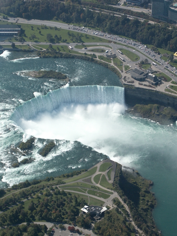
The Horseshoe Falls is considered to be the most impressive of the three falls that make up Niagara Falls. Approximately 90% of the water of the Niagara River flows over Horseshoe Falls, while the other 10% flows over the American Falls. The features that became Niagara Falls were created by the Wisconsin glaciation, about 10,000 years ago. The same forces also created the North American Great Lakes and the Niagara River. All were dug by a continental ice sheet that drove through the area like a giant bulldozer, deepening some river channels to make lakes, and damming others with debris. When the ice melted, the upper Great Lakes emptied into the Niagara River, which followed the rearranged topography across the Niagara Escarpment. In time, the river cut a gorge through the north facing cliff, or cuesta. Because of the interactions of three major rock formations, the rocky bed did not erode evenly. The top rock formation was composed of erosion-resistant limestone and Lockport dolostone. That hard layer of stone eroded more slowly than the underlying materials. Immediately below the hard-rock formation, comprising about two thirds of the cliff, lay the weaker, softer, sloping Rochester Formation (Lower Silurian). This formation was composed mainly of shale, though it has some thin limestone layers. It also contains ancient fossils. In time, the river eroded the soft layer that supported the hard layers, undercutting the hard caprock, which gave way in great chunks. This process repeated countless times, eventually carving out the Falls. The original Niagara Falls were near the sites of present-day Queenston, Ontario, and Lewiston, New York, but erosion of their crest has caused the waterfalls to retreat several miles southward. Just upstream from the Falls' current location, Goat Island splits the course of the Niagara River, resulting in the separation of the Canadian Horseshoe Falls to the west from the American and Bridal Veil Falls to the east. Although engineering has slowed erosion and recession in this century, the Falls will eventually recede far enough to drain most of Lake Erie, the bottom of which is higher than the bottom of the Falls. Engineers are working to reduce the rate of erosion to postpone this event as long as possible.
To get credit for this Earthcache you need to meet the following requirements. The answers to question number two is located at the coordinates listed above.
1.Take a photo of yourself in front of Horseshoe Falls (optional).
2.What is the crestline & flow rate of Horseshoe Falls.
3.***PLEASE DO NOT POST A PICTURE OF THE SIGN THAT HAS THE ANSWERS TO THE EARTHCACHE. ANY LOGS THAT HAVE THE SIGN IN YOUR PICTURE WITH THE ANSWER WILL BE DELETED. ANY ANSWERS POSTED IN YOUR LOGS WILL ALSO BE DELETED. YOUR WELCOME TO POST A PICTURE OF YOURSELF AT THE SIGN AS LONG AS THE PICTURE IS EDITED SO NONE OF THE ANSWERS ARE SHOWING.*** ****4/8/17 UPDATE**** There are reports that the sign needed for the answers is missing. Please upload a picture of yourself with the falls in the background until I could visit the falls and come up with a new way for visitors to answer the questions. I have gotten man e-mails asking if I was going to archive this. I have NO intention to archiving this Earthcache. This is my favorite one that I have out there and thousands of people have enjoyed visiting this location. I look forward to many more people coming to share their experience here.