Das nördlichste Hochmoor im Erzgebirge
Das Erzgebirge beherbergt einige Hochmoore. Hochmoore sind nährstoffarm, sauer und haben eine, an diesen feuchten Lebensraum und an diese extremen Bedingungen angepasste Tier- und Pflanzenwelt. Moore sind heutzutage sehr gefährdete Biotope. Das Absterben von Fichten in und an den Mooren führt zu Veränderungen des Kleinklimas, wie zunehmende Bodenwinde oder verstärkte Austrocknung. Dies führt zur Zerstörung des empfindlichen Ökosystems. Die Hochmoore des Erzgebirges entstanden nach der letzten Eiszeit, vor ca. 10.000 Jahren. Dort staute sich auf leicht geneigten Flächen und in Senken die Nässe.
Das Hormersdorfer Hochmoor ist das kleinste und nördlichste im Erzgebirge. Es wurde durch Entwässerung und Torfabbau im 19. Jahrhundert beinahe vollständig zerstört. Jedoch überlebten einige Pflanzen in den Torfresten. So konnte das Moor durch Wasserrückstau wieder regeneriert werden. Es wird ausschliesslich durch Regen gespeist.
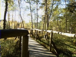
Seit 1942 ist das Moor geschützt und gehört zu einem Naturschutzgebiet. Das bedeutet, dass die Wege nicht verlassen werden dürfen. Wer es trotzdem versucht, riskiert im Moor zu versinken. Bitte bleibt auf dem hölzernen Weg, welcher entlang des Moors führt. Seid vorsichtig, die Holzbohlen sind ggf. rutschig!
Eure Aufgaben:
- Um welche Art von Moor handelt es sich?
- Geht auf die Aussichtsplattform und schaut Euch das Moor an. Welchen Farbton hat das Moorwasser im Vergleich zu "normalem" Wasser eines Sees?
- Beschreibt bitte in eigenen Worten kurz den anstehenden Boden in Farbe, Konsistenz, Geruch etc.
- Freiwillige Aufgabe: Wenn möglich, macht vor Ort ein spoilerfreies Foto von eurem Besuch. Qualitativ gute Fotos zu machen ist Bestandteil der Außentätigkeit von Geologen.
Schickt uns die Antworten und loggt den Cache (mit dem Foto). Ihr müsst nicht auf eine Freigabe warten.
Nur die korrekten Antworten in Verbindung gelten als Logberechtigung.
Wir wünschen Euch viel Spaß bei dieser geologischen Entdeckungsreise.
Viele Grüße vom Team DerkleineHasi
Herzlichen Dank an museion und das Team ellamarie für die konstruktiven Hinweise zur Anmeldung unseres ersten Earthcaches.

The most northern high moor of the Ore Mountains
The Ore mountains housing a couple of high moors. High moors are nutrient-poor, acidic and with a wet habitats in these extreme conditions adapted flora and fauna. Moors are very endangered biotops today. The dying off of the spruces in and around the moors goes along with smallclimate changes like increasing ground winds and strengthened dehydration and result in damage of this sensitive ecosystem.
The high moors of the ore mountains are developed after the last ice age, approximately 10.000 years ago. The wetness was dammed on slightly sloped areas and in hollows, where the ground was waterimpervious. The "High moor of Hormersdorf" is the smallest and the most northern moor of the Ore Mountains. It has been almost completely destroyed through dewatering and peat cutting in the 19th century. Because of some remaining peat rests some species survived. Due to water tailback it regenerated to high moor. It is feeded only by rain.
From 1942 onwards it is protected and belonges to a nature reserve. This means that you are not allowed to leave the path. Even if you risk, you are likely to sink in the moor. Please remain on the wooden planks leading along the moor. Be carefully! The planks may be slippery. Consider wheater conditions before you go there.
Your tasks:
- What kind of moor is it?
- Climb the platform and look at the moor. What colour tone does the water of the moor have in comparision to "common" water of a lake?
- Use your own words to describe the the ground. (Color, consistency, smell, ...)
- Optional Task: If you are able, post a picture free of spoilers of your visit at the site. Taking good quality photographs is part of the field work for geologists.
Mail us the answers and log the found (with the picture). You don't need to wait for log permission.
Only the correct answers are a valid log authorization.
Have a nice geological expedition.
Team DerkleineHasi