GEOCACHE “DE STUW”
De Maas ontspringt ongeveer 200 km ten noorden van Dijon in de Noord-Franse Vogezen in een heuvelachtig gebied genaamd "Plateau De Langres". Naast de Maas ontspringen hier ook de Seine, Marne en de Aube.
De Maas is 935 kilometer lang en gaat van een hoogte van 409 meter boven zeeniveau via Luxemburg en België naar Nederland waar ze bij Eijsden onder Maastricht ons land bereikt. Het Nederlandse deel van de Maas tot aan haar monding in het Haringvliet, is zo'n 300 km lang. De gemiddelde afvoer van de Maas is 230 m3 per seconde. Het hele jaar door wordt de Maas gevoed door regenwater.
Tot diep in de 19e eeuw stroomde de Maas door het Land van Heusden en Altena en mondde uit in de Waal bij slot Loevestein nabij Woudrichem. De Waal had vaak een hoger waterpeil dan de Maas daardoor konden de Noord Brabantse riviertjes hun water niet kwijt en overstroomden dan.
In 1883 werd bij wet besloten, de Maasmondwet, om de Maas van de Waal te scheiden. Hiertoe werd de Bergsche Maas nabij Waalwijk gegraven, die sinds 1904 de Maas vanaf Well in westelijke richting voortzet. Voorbij Geertruidenberg, het stadje waaraan de Bergsche Maas zijn naam ontleent, vormt de Amer zijn (natuurlijke) voortzetting waarna deze uitstroomt in het Hollandsch Diep. Vervolgens werd bij Poederoijensehoek een dam gelegd, zodat de "Afgedamde Maas" overbleef. De Bergsche Maas, die het historische Land van Heusden in tweeën deelde, werd gedeeltelijk door een nog oudere Maasbedding gegraven (tot 1273), waarvan tegenwoordig het parallel lopende Oude Maasje nog rest. Twee dorpen, Gansoijen en Hagoort, moesten voor de aanleg van de Bergsche Maas wijken.
Tussen 1918 en 1929 werd de Maas tussen Grave en Maasbracht gekanaliseerd, waarbij in Grave, Sambeek, Belfeld, Roermond en Linnen stuwen en schutsluizen gebouwd werden. In 1935 kwam het Julianakanaal tussen Borgharen (met stuw) en Maasbracht gereed waarmee het 47 km lange, vrijwel onbevaarbare traject van de Grensmaas werd overbrugd. Bochtafsnijding in de jaren dertig hebben de Maas beneden Grave 30 procent korter gemaakt.
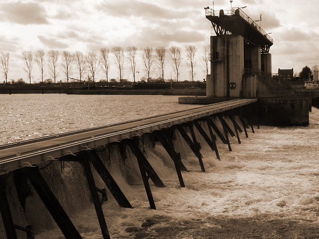
De stuw in Lith is de laatste stuw in de Maas. Tot hier is het verschil van eb en vloed van de zee nog merkbaar. De zeven stuwen zijn dus in de juiste volgorde stroomopwaarts: Lith, Grave, Sambeek, Belfeld, Roermond, Linne & Borgharen.
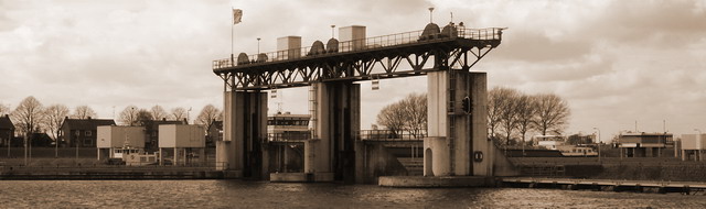
In Sambeek bevindt zich het machtige stuw- en sluizencomplex aan de oostrand van het dorp. Rond 1921 werd begonnen met de aanleg van stuw en sluis, een werk dat zo’n acht jaar zou duren. Op 4 oktober 1929 werd het sluizen complex in gebruik genomen. De sluis werd maar liefst 260 meter lang en 16 meter breed. Deze maten waren afgestemd op de scheepvaart van toen: er konden twee schepen mét sleepboten binnenvaren. Na de tweede wereldoorlog groeide de scheepvaart op de Maas snel, dus moest er worden uitgebreid. In 1969 kon een tweelingsluis in gebruik worden genomen. De capaciteit was meer dan verdrievoudigd. Momenteel liggen er weer plannen voor een verdere uitbreiding.
Vanuit Afferden kan men dicht bij "De Stuw" komen en zo het water met donderend geraas naar beneden zien storten. De cache is een eenvoudige multi met slechts 2 lokaties die beide over de weg zijn te vinden. Lopend langs de maas mag natuurlijk ook.
De opdracht is heel eenvoudig: Zoek bij de coördinaten die bovenaan de cachepagina staan de coördinaten van de FINAL!!!
Aan de caches aan beide zijden van het sluizencomplex Sambeek, genaamd "De Stoel" en "De Stuw", is een bonuscache verbonden: GC5TMCH "De StuwStoel"
Om deze bonuscache te kunnen loggen zijn 2 cijfercombinaties van 3 cijfers te vinden in de caches zelf.
De Stoel: Noteer de cijfers in de cache als xxx
De Stuw: Noteer de cijfers in de cache als yyy
Stuur een mail naar "Stuwstoelxxxyyy@gmail.com" In het antwoord vind je dan alle relevante informatie...
English Version
GEOCACHE “THE WEIR”
The Meuse rises approximately 200 km north of Dijon in the French Vosges Mountains in a low mountain area called "Plateau De Langres". Besides the Meuse, the Seine, the Marne and the Aube rises here.
The Meuse has a total length of 935 km and flows from 409 meter above sea level via Belgium to The Netherlands where she reaches the dutch border nearby Eijsden, just below the city of Maastricht. The Dutch part of the Meuse is about 300 km long before draining into the "Haringvliet" inlet of the North Sea. The average draining of the Meuse is 230 m3/sec. The Meuse is only fed by rainfall.
Until the late 19th century, the Meuse flows throughout the land of "Heusden" and "Altena" and drains in the Waal river nearby the castle of "Loevestein" in Woudrichem. However, the waterlevel in the Waal river was often higher then the Meuse which resulted in frequent floods of that area.
In 1889 a new law was accepted in which the Waal river and the Meuse were separated. To fullfill this law, a new canal has been dug nearby Waalwijk called the "Bergsche Maas". From 1904 on the Meuse flows to the West where it drains into the river "Amer" before it arrives in the "Hollands Diep". Hollands Diep is an estuary of the Rhine and Meuse river. Near Numansdorp it splits into the Haringvliet and the Volkerak.
Between 1918 and 1929 the river is canalized between Grave and Maastricht with several weirs in Grave, Sambeek, Belfeld, Roermond and Linnen. Between Maastricht and Maasbracht, an unnavigable section of the Meuse is bypassed in 1936 by the 36 km Juliana Canal.
The weir in the village Lith is the last one in the river Meuse. Until here the influence of the sea (low and high tide) is noticeable. So the 7 weirs in the river Meuse are (in correct order) upstream: Lith, Grave, Sambeek, Belfeld, Roermond, Linne & Borgharen.
The big weir and lock aggregate on the Eastside of Sambeek is build from 1921 on. It took 8 years before the lock was available for the first vessels. On October 4th, 1929 the lock was released. The lock is about 260 meters long and 16 meters wide. After World War 2 the shipping traffic on the Meuse increased rappidly so expansion was necessary. In 1969 a twinlock was available. Capacity was more than triplet. Nowadays furhter expansion is planned again.
From the eastside of the river nearby the village Afferden you can reach the weir on a close distance and see the water goes down with heavy roaring.
The cache itself is a simple multi which consist only of 2 locations you can reach by road. However taking a hike along the river is recommended.
The assignment is very simpel: Search nearby the given GPS coordinates on the top of this page the coordinates of the FINAL!!!
The Geocaches named "De Stoel" and "De Stuw", on both sides of the Weir in Sambeek, have a bonuscache called "De StuwStoel" (GC5TMCH)".
To log this bonuscache you have to visit both caches and find 2 numbercombinations of 3 numbers within the stash.
De Stoel: Notice these numbers as xxx
De Stuw: Notice these numbers as yyy
Send a mail to "stuwstoelxxxyyy@gmail.com" In the answer you'll find all relevant information...