
 The only way to access these caves is on a kayak. I found the best launching point to be N35 09.337 W120 40.645.
Sea Caves are formed by constant beating of waves against ocean cliffs. Waves pound the cliff faces with hundreds of pounds of force per wave eroding away the base of the cliffs. Where there are areas of weakness, that portion of the cliff erodes forming indentations. These indentations reinforce the erosion by focusing more energy from each wave into the confined space creating caves.
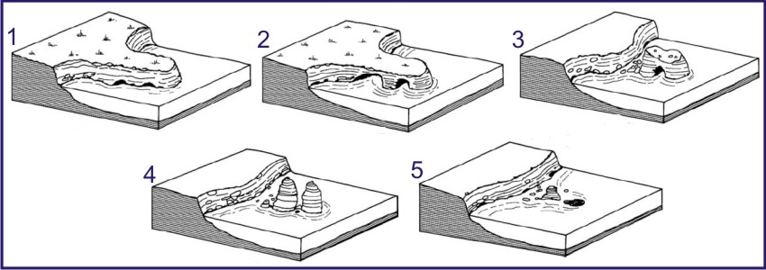 Continued erosion eventually erodes the cliffs and caves down, sometimes isolating remanents of the cliff off-shore in what are called sea stacks.
Rock formations can become weak for wide variety of reasons. The cliffs of this section of coast are made up of the Monterey Formation, a layered sedimentary rock. The contact between each layer in the formation is a point of weakness. Additionally, numerous minor faults run through the rocks caused by the uplift of the coastline that created the elevated marine terraces found in the area. These faults are also weak spots in the rock.
To identify a cave that formed along a bedding plane, look at the sides of the cave. If they are relatively flat with few layers in them the cave is forming parallel to the layering in the rock. The peak of the cave will appear to line up with one of the layers.
To identify a cave that formed along a fault, also look at the sides of the cave. There will be more layers of rock showing as fault often cut across the layering. At the peak of the cave a line (the fault) will continue up through the rock cutting across the layers.
Sometimes, areas of weakness cross and the sea caves forming along the seperate zones of weakness meet forming a tunnel or arch.
Logging requirements:
Send me a note with :
- The fact you stayed safe and used good judgment
- The text "GC1G4QB Caves of Dinosaur Park " on the first line
- The number of people in your group.
- How many are caves and how many are tunnels/bridges?
- How many formed along bedding planes and how many formed along faults?
- Based on the sequence in the diagram, which number picture best represents the geomorphology of the coastline at the coordinates?
The above information was compiled from the following sources:
- http://en.wikipedia.org/wiki/Sea_caves
- Bird, E, 2008. Coastal Geomorphology: An introduction. John Wiley and Sons, Ltd.
- http://teacher.scholastic.com/lessonrepro/lessonplans/theme/caves04.htm