An replacement cache for MD Meander. We've hidden this one in a
different location so thought it warranted a brand new cache,
loosely based around the same theme.
The cache is a Guided Tour around Market Drayton
to collect clues for the final cache. Don't be put off by the
number of waypoints - the cache can easily be completed in
under an hour.
Market Drayton is probably 8th Century Saxon in
origin and there has been a church on the site of the present St.
Mary's Church for over 1000 years. The town became a centre for
trade when, in 1245, the Abbot of Combermere was granted a charter
by Henry III to hold a market and a fair in the town. There is
still an open-air Market in Cheshire Street every Wednesday. It
remained as a small Market town well into the 20th century, only
experiencing larger growth in housing during recent years.
The Market Drayton Civic Society have placed
brown, circular information plaques on many buildings and it is
these which are used as the basis for the tour. The co-ordinates
for each plaque are given, but it is probably only necessary to go
to the general area of several of them, then look around. Find the
answers to the following questions and you will be able to work out
the co-ordinates for the final cache.
The co-ordinates given above are for the (free)
car park near to the Market Drayton Swimming Centre and Picnic
Area.
At the car park you get a good view of St.
Mary's Church on the hill above. Walk up Phoenix Bank towards the
town to start your walking tour.

 Wildcard Location - *very* close to one
of the other stages Wildcard Location - *very* close to one
of the other stages |
We thought it might be fun to add in a stage
where the location is not known in advance. We can say that the
location is *very* close to one of the main virtual locations
listed below - you just need to keep your eyes open at each stage
to spot it. The details are on a more conventional rectangular
information sign and not a plaque like the other stages. Look for
the list of "Important Events In Drayton's Later History". It's
quite a big sign so not easy to miss.
What year did Sir Rowland Hill purchase
the manor of Great Drayton? 15A5
| Rylands House - N52 54.196 W2
28.923 |
This was the Post Office and home of Richard
Grant, the postmaster from the 1790's until 1851. Just below the
house, down Phoenix Bank, are the remains of the ancient flight of
steps which led from the once bust industrial area on the banks of
the Tern to the "High Town" and the Church. The steps were in use
until the 1960's.
What date was the house restored?
19B6
| Billington's Bakery - N52 54.218 W2
28.992 |
No1 Church Street, on the corner, is the site of
the original Billington's Bakery and shop. It is thought that
gingerbread was first made here about 1817 by a Mr Thomas. The
business passed to a cousin, Richard Billington, in 1864 and the
gingerbread made from the original recipe still bears his name to
this day. The bakery was located in the cellar with the entrance
being down some steps on the left hand side of the building (now
bricked up). The tall bakery chimney has now been demolished.
What year did the bakery close?
19C7
| The Corbet Arms - N52 54.236 W2
29.011 |
The Corbet Arms has been one of the main meeting
places in the town for over two hundred years. Public meetings,
political meetings, bankrupcy proceedings, inquests into lunacy,
assemblies, balls and tax collecting took place here. Thomas
Telford stayed here in 1832 when he came to inspect the nearby
Shropshire Union Canal. It is said that Room "C" is haunted by a
young chaimbermaid who was jilted by one of the guests. The girl
hung herself there and has been known to disturb the peace of
guests sleeping in "her" room.
What year did the inauguration of the
Nantwich and Market Drayton railway take place here?
186D
| The Shambles - N52 54.241 W2 29.035 |
The Shambles used to be the site of a covered
butchers market from 1861 until it was demolished one hundred years
later. The early career of Elizabeth Ann Lewis, known as the "Queen
of Temperance" was launched on the steps of The Shambles. She used
to lecture on the dangers of drinking alcohol and drew large crowds
as she was known for her "eloquence and forceful personality". Her
brother, John, was one of the pioneers of Association Football and
was the referee of the first English Cup Final.
What year did an earlier "Markett House"
stand nearby until? 178E
| The Buttercross - N52 54.261 W2
29.067 |
The Buttercross is a symbol of the town and can
be seen on many signs in the area. It was built in 1824, quite some
time after the market first started. It was used to allow farmer's
wives to display and sell their wares under cover. If you look
round the outside of it, you may spot the crest of the Corbet
family, Lords of the Manor since the 1560's. The bell on top of the
structure used to be rung to summon the fire engine. This involved
collecting the horse from it's stables at the bottom of Phoenix
Bank, near where the swimming pool now is. Horses were sold in
Cheshire Street nearby at one time - the street was known for a
long time as "Horsemarket Street" as a result.
Since what year has a "Markett House"
been in the town? 17F0
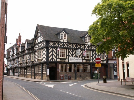
| Tudor House - N52 54.230 W2 29.044 |
Tudor House was built after the catastrophic
town fire of 1651 and is made of substantial box construction. The
building featured an interior courtyard, but this has since been
built over. The hotel has at one time been a fruiterer's shop, a
fishmonger's and a bank.
What is the year immediately below the
words "Tudor House" on the plaque? 1G53
| Chester's Prize Gingerbread Shop - N52
54.203 W2 29.096 |
It was from this shop that William Chesters, a
cousin of the Billingtons, baked and sold his "Chester's Prize
Gingerbread" from 1850. The bakery was at the rear of the shop.
What year did gingerbread baking cease
at the rear of this shop? 193H
| The Red House - N52 54.201 W2
29.092 |
The Red House is a large and imposing building.
It was once the home of Captain William Wilkinson who served on the
frigate Sirius at the Battle of Trafalgar. The Sirius had a shallow
draft and was able to sail close into land and was the first to
report to Admiral Lord Nelson that the combined French and Spanish
fleet was coming out of Cadiz harbour to do battle. After the
battle, Captain Wilkinson wrote home describing the battle and the
events following Nelson's death.
Battle of Trafalgar date:
18J5
| Warren Court - N52 54.153 W2 29.189 |
Warren Court was known for many years as "The
Manor House". It was built in the early 1700's and enlarged in
1778. It was home to three generations of family solicitors by the
name of Warren. One of them, Charles Warren, played a major role in
the capture of a natorious gand of local sheep rustlers, known
locally as "The Bravos". Sheep lifting in those days was a hanging
offence and two of the gang were hung while the remaining three
were deported to Australia. The last of the Warren family died in
1931 and the house was subsequently sold on and altered. Recently
the facade has been restored and the house converted to flats.
What year was the building converted
into flats? 19K7
| Cotton's House - N52 54.140 W2
29.188 |
Cotton's House was built around 1600 on land
granted to the Cotton family by Henry VIII. The will and inventory
of Philip Cotton, who lived here and died in 1682, still exists and
details what furniture stood in each room at the time of his death.
Subsequently, the house became the home of a retired slave dealer
who traded through Liverpool, Africa and the USA.
What year did Henry VIII grant the land
to the Cotton family? 153L
| Mount Lane School - N52 54.109 W2
29.078 |
This building was used as Mount Lane School up
to the 1960's. Originally, it has been opened as the National and
Sunday School under the guidance of Reverend Lee in 1835. The
building is now used as a nursery so we'd ask you not to loiter
around once you have got the details you need (for obvious
reasons). Just round the corner from the old school is Tupp Steps,
which link the Tern valley to the town centre. They meet another
ancient pathway on the right - Love Lane. This led to Walkmill Road
and the mills further downstream on the Tern.
How many pupils can the school
accommodate? M00
| Final Cache - N52 5A.E(B-C-1)(D+F-1) W2
2K.K(G+H-M)(J+L) |
Please be extremely stealthy when retrieving the
cache as there can be muggles near to GZ.
The cache is a small lock n lock container
hidden inside a camo bag.
To double check your co-ordinates for the final
cache, the sum of the last 4 digits of the northings and westings
are 14 and 33 respectively.
Hall Of Fame
| First to Find: |
Izzy and the
Lizard King |
| Second to Find: |
Fifth
Barrowcliffe |
| Third to Find: |
Beetees |