This earth cache was originally posted by Lepman and adopted by Team Boon in January 2020. We would like to take this opportunity to thank Lepman for maintaining this cache for many years!
 Earthcache Saasthal
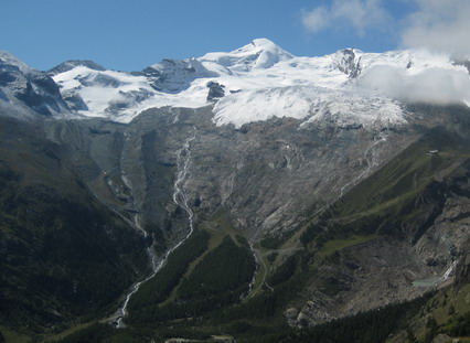
Welcome in the Saasthal, a beautiful area in the south of Switzerland called Wallis. Here you can visit nice small villages and hike on awesome mountains. Follow a trail near Saas-Fee and learn more about the ice age, the forming of glaciers and glacial crevasses. In winter the trail is more difficult to find and to follow.

Walk from Saas-Fee to N46 05.896 E7 55.204
A trail starts here, follow it to N46 05.972 E7 55.178
How does glacial ice come into being? Glacial ice is made up of snow which slowly into firn and finally into ice over the course of time through processes of transformation (so-called metamorphism). During this process, the snow takes on a more and more compact form as its volume decreases and its density increases. Year after year more snow and ice accumulates in this manner in the accumulation zone. Finally the weight and pressure become so great that the ice slowly begins to move down the valley.
- Question 1: What is glacial milk?
- Question 2: How many stages are there in the life of a snow crystal?
Walk to N46 06.020 E7 55.144
Why are glaciers so important for us?
- Question 3: What do glaciers influence?
Walk to N46 05.881 E7 55.103
Traces of the ice age: When the last ice age came to an end a good 10,000 years ago, the giant networks of ice rivers, which then penetrated far into the foothills, melted back to the central Alps. When they retreated, they left behind piles of rock rubble that they had transported, this is called moraine. These remains deposited by the ice enable us to reconstruct the outlines of glaciers at that time.
- Question 4: What's the difference in color between the accumulation zone and the deposition zone?
- Optional: Make a picture of at least one team member and GPS visible
Walk to N46 05.862 E7 54.905
When the ice breaks: Glacial ice can not be shaped at will. When it is subjected to force either pushing or pulling it, crevasses appear in the surface. These are sometimes over 60 metres deep. They often appear and disappear very quickly. These crevasses develop mostclearly on slopes, narrow passes or at points where the glacier widens. We differentiate between different types of crevasses, for example longitudinal, transverse or marginal cravesses or the spectacular fissured seracs (ice towers).
- Question 5: Why can glacial crevasses often not be seen?
From here you can walk further up the mountain or go back to Saas-Fee.
How can this earthcache be logged:
Send the answer of question 1 - 5 to us via our profile at the top of the page or email them to gcteamboon@gmail.com. After our approval you can log this cache. A picture is not required but would be very nice.

 Earthcache Saasthal
Willkommen im Saastal, einer wunderschönen Gegend im Süden der Schweiz genannt Wallis. Hier können Sie schöne kleine Dörfer besuchen und auf ehrfürchtige Bergen wandern. Folgen Sie den Spuren in der Nähe von Saas-Fee und erfahren Sie mehr über die Eiszeit, die Bildung von Gletschern und Gletscherspalten. Im Winter ist es schwieriger die Strecke zu finden und ihr zu folgen.
Gehe von Saas-Fee zu N46 05.896 E7 55.204
Eine Spur started hier, folge ihr zu N46 05.972 E7 55.178
Wie entsteht Gletschereis? Gletschereis besteht aus Schnee, der sich im Verlaufe der Zeit durch Umwandlungs-prozesse (Metamorphose) langsam in Firn und schliesslich in Eis umwandelt. Der Schnee nimmt dabei eine immer kampaktere Form an, gleichzeitig vermindert sich das Volumen und die Dichte nimmt zu. Jahr für Jahr häuft sich so im Närhgebiet mehr Schnee und Eis auf. Schliesslich werden Gewicht und Druck so gross, dass das Eis langsam talwärts zu fliessen beginnt.
- Frage 1: Was ist Gletschermilch?
- Frage 2: Wie viele Stadien gibt es im Leben einer Schneeflocke?
Gehe weiter zu N46 06.020 E7 55.144
Warum sind Gletscher so wichtig für uns?
- Frage 3: Auf was haben Gletscher Einflüsse?
Gehe weiter zu N46 05.881 E7 55.103
Spuren der Eiszeit: Als die letzte Eiszeit vor gut 10'000 Jahren zu Ende ging, schmolzen die riesigen, damals bis weit ins Vorland vorgedrungenen Eisströme wieder ins Alpeninnere zurück. Bei ihrem Rückzug hinterliessen sie Ansammlungen von transportiertem Gesteinschutt, sogenannte Moränen. Diese Eislandreste ermöglichen es, die damalige Gletscher-umrisse zu rekonstruieren.
- Frage 4: Was ist der Unterschied in Farbe zwischen das Nährgebiet und das Zehrgebiet?
- Optional: Machen Sie ein Bild von mindestens einem Teammitglied und GPS sichtbar
Gehe weiter zu N46 05.862 E7 54.905
Wenn das Eis zerbricht: Gletchereis ist nicht beliebig verformbar. Bei grossen Druck- oder Zugkräften reissen an der Oberfläche Spalten auf, welche manchmal über 60 Meter tief sind. Sie entstehen und verschwinden oft sehr rasch. Am deutlichsten entwickeln sich die Brüche bei Gefällsstufen, bei Engpässen oder Weitungen des Gletschers. Man unterscheidet verschiedene Spaltentypen wie z.B. Längs-, Quer- und Rand- spalten oder die spektakulär zerklüfteten Séracs (Eistürme).
- Frage 5: Warum sind Gletscherspalten oft nicht sichtbar?
Von hier können Sie weiter den Berg hinaufwandern oder nach Saas-Fee zurückkehren.
Diesen earthcache loggen:
Senden Sie uns die Antwort auf die Fragen 1 bis 5 über unser Profil oben auf der Seite oder senden Sie sie per E-Mail an gcteamboon@gmail.com. Nach unserer Genehmigung können Sie diesen Cache loggen. Ein Bild ist nicht erforderlich, wäre aber sehr schön.
An Earthcache is an educational form of a virtual cache. The reward for these caches is learning more about the planet on which we live - its landscapes, its geology or the minerals and fossils that are found there. Earthcaches are developed in association with the Geological Society of America. For more information go to (www.earthcache.org)