
 This is a State Beach. There are various free parking
options on top of the cliffs. Then you will need to make your
way down the cliff to the coordinates.
This is a State Beach. There are various free parking
options on top of the cliffs. Then you will need to make your
way down the cliff to the coordinates.
Seabright Beach owes its existence to the Santa Cruz Yacht
Harbor Jetty. Prior to the 1960s this shoreline looked similar to
the beach cliffs further north. Waves pounded directly against the
base of the cliffs eroding out a marine terrace (see
Marine Science Earthcache.)
 Sand was prevented from building up along
the shore by a current southward created by the waves
approaching the shore at an angle. When waves approach the
shore at an angle they generate a current parallel to the
shore called the longshore current or littoral drift. At
various points along the shore, the water in the longshore
current returns back to the ocean in rip currents. Rip
currents are fast moving currents that move directly out to
the ocean. The result is the transport of sand southward along
the coast. Because of the relatively high energy of the waves
along this section of coast, the sand moved very quickly down
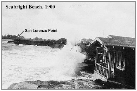
the coast, never building up as a beach. Photos from the 1900s
(found in the USGS Open-File Report 00-438) looking north from
near the Santa Cruz Yacht Harbor Jetty shows the waves
pounding the base of the cliffs of this beach. The sea stack
at the coordinates is in the picture just below the arrow
pointing at San Lorenzo Point.
Sand was prevented from building up along
the shore by a current southward created by the waves
approaching the shore at an angle. When waves approach the
shore at an angle they generate a current parallel to the
shore called the longshore current or littoral drift. At
various points along the shore, the water in the longshore
current returns back to the ocean in rip currents. Rip
currents are fast moving currents that move directly out to
the ocean. The result is the transport of sand southward along
the coast. Because of the relatively high energy of the waves
along this section of coast, the sand moved very quickly down
the coast, never building up as a beach. Photos from the 1900s
(found in the USGS Open-File Report 00-438) looking north from
near the Santa Cruz Yacht Harbor Jetty shows the waves
pounding the base of the cliffs of this beach. The sea stack
at the coordinates is in the picture just below the arrow
pointing at San Lorenzo Point.
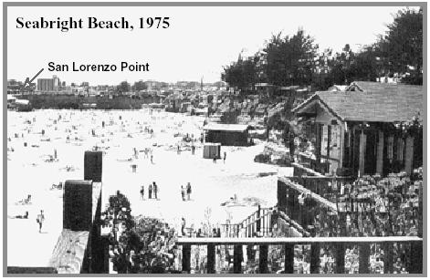 This southward transport of sand was
interrupted in the 1960s by the construction of the Santa Cruz
Yacht Harbor Jetty. This jetty sticks out into the ocean
blocking the longshore current and sand began piling up behind
it. This created one of the widest beaches in the Northern
Monterey Bay. A photo from 1975, also from the USGS, taken
from the same location shows this growth of the beach. The
house on the right side is the same in both pictures.
This southward transport of sand was
interrupted in the 1960s by the construction of the Santa Cruz
Yacht Harbor Jetty. This jetty sticks out into the ocean
blocking the longshore current and sand began piling up behind
it. This created one of the widest beaches in the Northern
Monterey Bay. A photo from 1975, also from the USGS, taken
from the same location shows this growth of the beach. The
house on the right side is the same in both pictures.
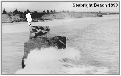 One of the examples that shows the beach
widening is the burial of a sea stack at the northern end of
the beach. A sea stack is an isolated column of rock that is
the remnant of a sea cliff, arch, or headland. Photos from the
1890s (found in the USGS Open-File Report 00-438) show this
sea stack being pounded by waves a short way off the coast.
Today the coordinates bring you to the same sea stack buried
in the beach sand.
One of the examples that shows the beach
widening is the burial of a sea stack at the northern end of
the beach. A sea stack is an isolated column of rock that is
the remnant of a sea cliff, arch, or headland. Photos from the
1890s (found in the USGS Open-File Report 00-438) show this
sea stack being pounded by waves a short way off the coast.
Today the coordinates bring you to the same sea stack buried
in the beach sand.
The amount of burial changes seasonally since sand on the beach
is constantly being moved around. As you can see, each wave that
comes in pushes around the sand on the beach, turning the ocean
water at the shore brown. The difference in energy between summer
and winter waves drastically changes the look of the beach. To
examine this seasonal change, it is good to have names for the
different parts of the beach. In this case, we’ll look at three
parts, the backshore, the foreshore, and offshore.
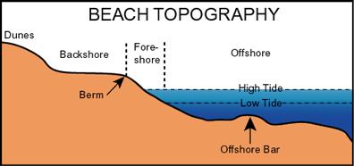 The backshore begins at the vegetated
cliffs to the high tide level and is comprised of the berm and
berm crest. The berm is the relatively flat sandy area where
everyone loves to put their beach towels. At the berm crest,
beach slopes more steeply to the high tide level. The width of
the berm changes seasonally. During the summer it is wider
than during the winter. This change in width results in the
moving shoreward or seaward of the next two zones. The
foreshore begins at the high tide line and stretches to
the low tide line. This section of beach in usually slopes
downward at a uniform level. Because of the tides, this
section of beach is periodically below sea level or above sea
level.
The backshore begins at the vegetated
cliffs to the high tide level and is comprised of the berm and
berm crest. The berm is the relatively flat sandy area where
everyone loves to put their beach towels. At the berm crest,
beach slopes more steeply to the high tide level. The width of
the berm changes seasonally. During the summer it is wider
than during the winter. This change in width results in the
moving shoreward or seaward of the next two zones. The
foreshore begins at the high tide line and stretches to
the low tide line. This section of beach in usually slopes
downward at a uniform level. Because of the tides, this
section of beach is periodically below sea level or above sea
level.
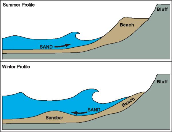 Beyond the foreshore is the
offshore beginning at the low tide line and extending
off shore. This section of the beach is always below sea level
but constantly affected by the waves. The offshore profile
changes seasonally. During the summer, it is a relatively
uniform slope down. During the winter, a trough (low point)
forms with mounds of sand (bars) eroded from the berm
shoreward and seaward of the trough.
Beyond the foreshore is the
offshore beginning at the low tide line and extending
off shore. This section of the beach is always below sea level
but constantly affected by the waves. The offshore profile
changes seasonally. During the summer, it is a relatively
uniform slope down. During the winter, a trough (low point)
forms with mounds of sand (bars) eroded from the berm
shoreward and seaward of the trough.
The seasonal changes noted above are caused by the different
energy levels of summer and winter waves. Winter storms generate
shallow waves with more energy than summer waves. The winter waves
erode sand off the beach and store it in offshore bars.
The winter waves are generated by local storms. They form large
waves that do not extend deep beneath the ocean surface. Thus as
they crash on the shore they have enough energy to pick up sand and
pull it off of the foreshore into deeper water where the shallow
waves do not reach. The largest storm generated waves also erode
the face of the berm crest, reducing the width of the berm. The
sand is then deposited in sandbars off-shore.
During summer, the waves are generated by storms far out to sea.
These waves are milder but because they have been traveling across
the ocean, they have developed into deeper waves. As these waves
come to shore they pick up the sand that was deposited int he
off-shore sand bars and transport it back onto the foreshore. As
the water flows back to the ocean, there is not enough energy to
transport as much sand as the wave brought onto the forshore back
off shore, resulting in a net gain of sand. This results in the
gradual build up of the berm crest and the berm widens for the
summer.
Since the sea stack is near the foreshore, the amount of burial
could change seasonally.
Logging requirements:
Send me a note with :
- The text "GC1FMND Seabright Beach Building" on the first
line
- The number of people in your group.
- Estimate the height of the sea stack that remains unburied at
the time of your visit. (This should change seasonally). Put this
in your "found it" log.
- Using your gps, at the time of your visit determine the width
of the beach along a line perpendicular to the shore from the base
of the cliffs, though the sea stack to the water. (Yes, the tides
will change this measurement by a few feet, but seasonal changes
should still be seen).Put this in your "found it" log.
The above information was compiled from the
following sources:
-
http://coastalchange.ucsd.edu/st3_basics/beaches.html
- KIKI PATSCH and GARY GRIGGS, OCTOBER 2006,
LITTORAL CELLS, SAND BUDGETS, AND BEACHES: UNDERSTANDING CALIFORNIA
S SHORELINE; INSTITUTE OF MARINE SCIENCES UNIVERSITY OF CALIFORNIA,
SANTA CRUZ CALIFORNIA DEPARTMENT OF BOATING AND WATERWAYS
CALIFORNIA COASTAL SEDIMENT MANAGEMENT WORKGROUP
-
http://www.ocean.uni-bremen.de/EInfo/materialien/elemOc/top12-17/topic14.html
- Cheryl Hapke, GEOLOGY AND COASTAL HAZARDS IN
THE NORTHERN MONTEREY BAY,CALIFORNIA FieldTripGuidebook
November4,2000 Open-FileReport 00-438, USGS
- Office of Naval Research; Habitats: Beaches -
Characteristics;
http://www.onr.navy.mil/focus/ocean/habitats/beaches1.htm