This EarthCache is part of a series of four EarthCaches, following the Falls Trail and Highland Trail, in a 5 mile hiking loop. This is one of three on the Falls Trail section. Hikers on the Falls Trail should be in good physical condition, wear sturdy boots, and use caution due to slippery/wet conditions and steep trail sections.
Ricketts Glen State Park is located on the Red Rock and North Mountains of the Allegheny Front. The Allegheny Front is an escarpment forming the boundary between two of Pennsylvania's main geologic regions, the Allegheny Plateau and the Ridge and Valley region. To the north the Allegheny Plateau consists almost entirely of horizontal layers of sedimentary rock. To the south of the escarpment, many tilted layers of sedimentary rock form the Ridge and Valley region. The Allegheny Front is capped by hard sandstone, in contrast to the less resistant shales and sandstones found in the Ridge and Valley below.
All of the exposed rock in the park was originally deposited as unconsolidated gravels, sands, and muds by ancient rivers that flowed across the region from about 370 to 340 million years ago, when what is now Pennsylvania, was located south of the equator. These sediments accumulated on flood-plains near sea level, and as the region subsided they became buried by other sediments. Several thousand feet down in the earth's crust these sediments were consolidated into solid rock by pressure and high temperatures. Then about 250 million years ago a collision between the North American continental plate and Africa deformed the rocks into the large tight folds of the Ridge and Valley and the gentler folds of the Allegheny Plateau. Continued erosion beginning at this uplift has removed over 5,000 feet of overlying rock to date.
Equally important in the formation of the park today were the glaciers. In the last million years at least three continental glaciers have buried northeastern Pennsylvania under thousands of feet of ice. The last glacial event happened about 20,000 years ago and left extensive evidence of it's advance. This glacier picked up large blocks of sandstone from the ledges, scoured up loose soil and rock, cut striations into the bedrock of the Pocono Formation, and finalized changes in the drainage pattern that were started by earlier ice sheets.
A waterfall is where a river or a stream, flows over a large step in the rocks and loses elevation. Over a period of years, the edges of this shelf will gradually break away and the waterfall will steadily retreat upstream, creating a gorge of recession. Often, the rock stratum just below the more resistant shelf will be of a softer type, meaning undercutting, due to splashback, will occur here to form a shallow cave-like formation known as a rock shelter or plunge pool under and behind the waterfall. Eventually, the outcropping, more resistant cap rock will collapse under pressure to add blocks of rock to the base of the waterfall. These blocks of rock are then broken down into smaller boulders by attrition as they collide with each other, and they also erode the base of the waterfall by abrasion, creating a deep plunge pool.
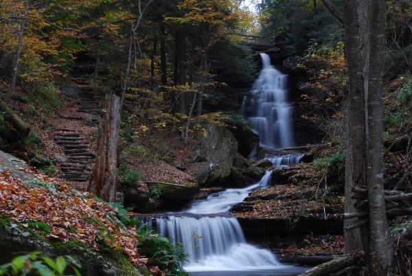
The changes in the drainage pattern of Kitchen Creek forced it to take a greater flow of water than the slope of the Glens could handle and over time cut more than 20 waterfalls into the glens. The waterfalls in the glens range in height from 11 to 94 feet.
The Falls Trail and the Highland Trail is a 5 mile loop with challenging terrain but some of the best scenery in Pennsylvania. I see many families with children on the Falls Trail and they seem to do fine but please remember to keep an eye on them. Be sure to pick up a park map at the visitor center.
Types of Waterfalls:
Waterfalls that remain in contact with the underlying rock:
Cascade: generally water that flows down in small steps or stages.
Chute: A violent section of water that is forced through a narrow passage due to cliff walls or large rocks.
Fan: falls through a relatively narrow crest and spreads out and becomes wider as it descends.
Horsetail: descends down remaining in contact with the surface most of the time.
Scree/Talus: flowing over a chaotic mix of rock debris on a slope usually found at the base of a cliff or steep incline.
Slide: glides over a single slab of rock maintaining smooth continuous contact.
Waterfalls that separate from the underlying rock:
Block/Sheet: drops over a ledge forming what appears to be a "sheet" of water - usually not broken into segments and it is wider than it is tall.
Cataract: waterfall that is large, very powerful and rushes down with force.
Classical: similar to Block, but roughly equal in height and width
Curtain: similar to Block, but typically taller than wide.
Plunge: descends vertically without contacting the underlying surface.
Punchbowl: falls through a constricted area and descends down into a pool of water.
Veil: falls over rocks creating a thin layer of water that just barely covers it's surface.
Other Descriptive Types:
Parallel: falls are side-by-side and fall similar to each other.
Ribbon: descends in a narrow strip significantly taller than it is wide.
Segmented: Pieces of land segment the river (same watercourse) causing the water to fall in sections.
Slot/Keyhole: pushes through a narrow area before falling.
Tiered: Separate waterfalls falling consecutively and in close proximity so generally they can be seen together. Any type of falls can be tiered.
Twin: side-by-side but do not have to be similar in type. (Triple and more can exist as well)
To claim this as a find:
1. Pick at least one waterfall on the Ganoga Glen side, classify it using the above descriptive types, and post a photo of yourself and your GPS in front of it.
2. Pick at least one waterfall on the Glen Leigh side, classify it using the above descriptive types, and post a photo of yourself and your GPS in front of it.
3. Pick at least one waterfall south of the Waters Meet Bridge, classify it using the above descriptive types, and post a photo of yourself and your GPS in front of it.
4. Head to the Rte. 118 parking area, find Adams Falls, classify it using the above descriptive types, and post a photo of yourself and your GPS in front of it.
E-mail the falls name and type to me for 1-4, and post the photos of 1-4 with your log (The photos are now optional but the answers are still required) within a few days. Failure to comply with these requirements will result in log deletion.
Good luck and good caching.
- Rev Mike