Bludny balvan / Glacial Erratic (Earth) EarthCache
Bludny balvan / Glacial Erratic (Earth)
-
Difficulty:
-

-
Terrain:
-
Size:  (not chosen)
Please note Use of geocaching.com services is subject to the terms and conditions
in our disclaimer.
Možná na to nevypadá, ale je z daleka...
It may not look like it, but it comes from far away...
Nejen v Jeseníku, ale v celé oblasti Moravské brány je možné
spatrit celou radu kamenu, které do techto míst doputovaly pri
posunu ledovcu z dalekých severských kraju. Navštivte s námi jeden
takový kámen, jenž zustal ležet prímo v centru mesta.
Bludný ("eratický") balvan je blok horniny, který byl v dobe ledové
prepraven ledovcem na velkou vzdálenost, kde byl po roztátí ledovce
usazen v geologicky zcela odlišném prostredí. Tato teorie se
objevila až koncem 19. století, do té doby se jejich výskyt
vysvetloval potopou sveta, vulkanickou cinností ci „cinností“
certu, kyklopu a dalších bájných tvoru. Oznacení pochází z
latinského „erare“, znamenajícího "bloudit". Príkladem mohou být
balvany skandinávské žuly rapakivi a jiných hornin z Ålandských
ostrovu a dalších míst Skandinávie na severní Morave, které byly
dopraveny pohybem pevninského ledovce ve starších ctvrtohorách v
období halštatského (cca pred 470-430 tis. lety) a sálského
zalednení (pred 230-170 tis. lety). Granity a ruly (pro svoji
odolnost) v nálezech prevažují, dalšími horninami nalezenými na
severní Morave jsou migmatity, pískovce, vápence.
Pestrost nálezu príkladne dokumentuje naucná zahrádka 32 bludných
kamenu budovaná ve Velké Kraši.
Na uvedených souradnicích krome kamene najdete jesenickou vodní
tvrz, které je venována i stejnojmenná keš.
K zalogování nálezu postací splnit následující podmínky:
1.) najdete na uvedených souradnicích bludný balvan :-)
2.) poridte foto, na kterém budete vy, vaše GPS a balvan (ne však
citelná cedule)
3.) zjistete složení a hmotnost balvanu
4.) foto priložte k logu a oba údaje nám pošlete pres profil
Nemusíte cekat na potvrzení, jen v prípade nesprávného splnení
úkolu od nás asi ješte uslyšíte :-)
Dobrý lov!
A glacial erratic is a piece of rock that deviates from the size
and type of rock native to the area in which it rests; the name
"erratic" is based on the errant location of these boulders. These
rocks were carried to their current locations by glacial ice, often
over hundreds of kilometres. Erratics can range in size from
pebbles to large boulders such as Big Rock (16,500 tons) in
Alberta. Geologists identify erratics by studying the rocks
surrounding the position of the erratic and the composition of the
erratic itself. Erratics were once considered evidence of a massive
flood approximately 10,000 years ago, similar to the legendary
floods described in the texts of ancient civilizations throughout
the world. Ancient legends of an epic flood come from many cultures
including Mesoamerican, Sumerian (Epic of Gilgamesh), Hebrew (Old
Testament) and Indian culture. In the 19th century, many scientists
came to favor erratics as evidence for the end of the last glacial
maximum (ice age) 10,000 years ago, rather than a flood. Geologists
have suggested that landslides or rockfalls initially dropped the
rocks on top of glacial ice. The glaciers continued to move,
carrying the rocks with them. When the ice melted, the erratics
were left in their present locations.
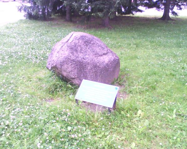
This particular „erratic stone“ is located in the centre of
Jeseník, near an old water fort – don’t forget to visit the nearby
traditional cache! The stone came from what is now the southwest of
Finland and is one of the biggest erratic stones in the region.
The reason why "erratic stones" appear so frequently in the area
around Jeseník, the "Moravian Gate", is because of the unique
landscape: a gap between two mountain ranges had become the place
where, for millenia, glaciers ended their long and slow journey
from the north. To learn more about erratic stones in this region
you should visit the "stone garden" in Velká Kraš, an exhibition of
32 erratic stones found in the area around Jeseník and the town
Vidnava. The Moravian Gate is also a water divide between the
Baltic and the Black Sea.
To log this cache, you have to follow these steps:
1.) Locate the stone at the given coordinates :-)
2.) Take a photo of yourself, your GPS unit and the stone (without
the info panel or so that it is illegible)
3.) note the type and weight of the stone
(since the info panel is in czech only: type = the first 3 words;
weight: number in second-to-last line)
4.) attach the photo to your log and send us the answers via
profile
Enjoy the hunt!
Additional Hints
(No hints available.)