Oil is one of Kern County's major economic resources. One of the first clues that oil was present is the fact that it sometimes finds its own way to the surface. The place where the oil, asphalt or tar naturally comes to the surface is called an oil or tar seep or "brea". The seeps are best viewed in the summer as the hot temperatures make the tar less viscous and they form little "streams" and "pools". During the winter the seeps do not flow as easily and will be a bit less impressive. The tar and oil are found in shales and diatomaceous earth on the east side of the Temblor Mountains in the Monterey Formation dating back to the Miocene (20 to 5 million years ago). The tar is able to find its way to the surface through fractures and cracks caused by the folding and faulting of the nearby San Andreas Fault on the other side of the Temblors. The oil itself was formed from the remains of zooplankton and algae that lived in a shallow sea and transformed by heat and pressure over millions of years. The Tulumne Yokut Indians were the first to exploit the tar. They used it as a glue, a trade item, and a waterproofing agent. The tar seeps were also where the first commercial exploitation occurred, starting in the early 1860's by the Buena Vista Petroleum Company. Rather than pumping the oil out of the ground with a well, it was collected at the seeps. In some cases there were "oil mines". An oil mine was a shallow hole or pit that was dug in the ground to where the oil or tar started to seep out. A worker would be lowered down into the mine and would fill buckets with the stuff, while someone at the surface would pull it up. It was incredibly dirty, hot and dangerous work and so most "miners" would work naked and be washed at the end of the day. The workers not only had to contend with the tar in the pits, but also the hot weather of the San Joaquin valley and noxious fumes from the oil, tar and gas. The mines were not very economical and eventually gave way to derricks and wells in the 1920's. An example of an oil mine can be found at N35°17.627, W119°38.253 (a short walk away from this earthcache site). The mine is covered by a large metal grate, but you would be wise NOT to test your weight on it. If you listen carefully you will be able to here the tar bubbling and gurgling.
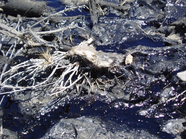
As with its famous cousin, the La Brea Tar Pits, to the south, McKittrick's oil seeps also trapped its fair share of animal life. Paleontologic studies of these seeps began in the early 1900's. Excavation of the seeps was completed in the 1940's by both the University of California and Kern County Museum. As of 1968 over 43 different mammals and 58 different bird species had been identified. Some of these species are now extinct. Bison, saber-toothed cat, dire wolf, camel and elephant, as well as smaller animals have been identified. Most of the animal remains date back to the Pliestocene (10000 to 40000 years ago). There were a disproportionate amount of predator species in the pits. This is because when an animal became stuck in the tar it would become "bait" for predators, which would in turn get stuck. One small animal could cause many predators to become stuck over a short period of time. As you walk around the site you might notice that the same process that trapped those animals thousands of years ago is still at work today!
Also of note - The shale and diatomaceous earth that does not contain any oil or tar is mined nearby for kitty litter. It is ideal because it is very absorbent and takes very little processing other than crushing and bagging. The only disadvantage is that there are gypsum seams in the formation that, when crushed with the diatomaceous earth, is sometimes mistaken for glass!
If you are interested in more information about the geology, paleontology, or history of the oil industry in the area then there are two great museums you should visit. The first is in Taft: the West Kern Oil Museum. This museum is free of charge and has great exhibits on all things pertaining to oil in this part of the world. The other museum is in Bakersfield: the Buena Vista Natural History Museum. This museum has more information about the paleontology of Kern County and does charge a small entrance fee. The hours of operation may vary by season, so it is wise to check their websites for location, hours of operation, and any applicable entrance fees.
TO LOG THIS CACHE PLEASE SEND THE ANSWERS TO THE FOLLOWING IN AN E-MAIL:
1. Count how many separate seeps are active from the roadside.
2. Animals continue to be trapped by the tar. How many animals can you identify? Can you tell what they are? If so, please describe.
3. Can the vegetation in the area be used to locate a seep? Why or why not?
4. Please post a picture of yourself in front of one of the seeps, or at the very least a picture of your GPS near one of the seeps.
SOURCES:
West Kern Oil Museum Buena Vista Natural History Museum website: http://www.sharktoothhill.com/tarseeps.html
Geology of the McKittrick Tar Pits: http://www.geocities.com/mudsmeller/tarpits_geol.html