|
LUSITANI
"Beira Interior Norte"

[PT]
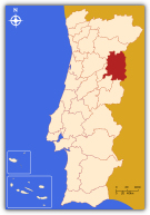 A Beira Interior Norte é uma sub-região estatística portuguesa, parte integrante da Região Centro e do Distrito da Guarda. Limita a norte com o Douro, a leste com a Espanha, a sul com a Beira Interior Sul e Cova da Beira e a oeste com a Serra da Estrela e com Dão-Lafões. Tem uma área total de 4.251 km² e em 2001 registava uma população de 115.326 unidades. Compreende 9 concelhos: Almeida, Celorico da Beira, Figueira de Castelo Rodrigo, Guarda, Manteigas, Mêda, Pinhel, Sabugal e Trancoso. Destas são cidade: Guarda (capital distrital), Pinhel, Trancoso, Mêda e Sabugal. A Beira Interior Norte é uma sub-região estatística portuguesa, parte integrante da Região Centro e do Distrito da Guarda. Limita a norte com o Douro, a leste com a Espanha, a sul com a Beira Interior Sul e Cova da Beira e a oeste com a Serra da Estrela e com Dão-Lafões. Tem uma área total de 4.251 km² e em 2001 registava uma população de 115.326 unidades. Compreende 9 concelhos: Almeida, Celorico da Beira, Figueira de Castelo Rodrigo, Guarda, Manteigas, Mêda, Pinhel, Sabugal e Trancoso. Destas são cidade: Guarda (capital distrital), Pinhel, Trancoso, Mêda e Sabugal.
Esta é uma zona muito vasta, situada no interior Norte do País e com uma grande linha de fronteira com Espanha. Dada a sua extensão possui uma grande variedade orográfica, sendo afectada a Sul, na zona da Guarda, pela Serra da Estrela e a Norte principalmente pela bacia do rio Côa. Por isso pode dizer-se que é constituída principalmente por planaltos,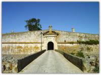 normalmente na zona dos 600m acima do nível do mar, com excepção das zonas mais a Sul, onde os rios Mondego e Zêzere cavaram grandes e escarpados vales, e a norte com a Serra da Marofa. Esta é uma zona com uma população envelhecida e com um baixo nível de escolaridade. O fenómeno de envelhecimento populacional vivido em Portugal assume, na Beira Interior Norte, proporções preocupantes, sobretudo nos concelhos geograficamente mais interiores, destacando-se a Guarda como o concelho “mais jovem” de toda a região. normalmente na zona dos 600m acima do nível do mar, com excepção das zonas mais a Sul, onde os rios Mondego e Zêzere cavaram grandes e escarpados vales, e a norte com a Serra da Marofa. Esta é uma zona com uma população envelhecida e com um baixo nível de escolaridade. O fenómeno de envelhecimento populacional vivido em Portugal assume, na Beira Interior Norte, proporções preocupantes, sobretudo nos concelhos geograficamente mais interiores, destacando-se a Guarda como o concelho “mais jovem” de toda a região.
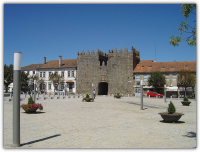
É uma região com uma grande riqueza monumental, pois por aqui existem muitos e variados pelourinhos, castros e castelos, alguns dos quais estão representados nas 5 quinas da bandeira de Portugal. É disso exemplo o castelo de Sortelha, freguesia do concelho do Sabugal. É uma zona onde o granito, os arenitos, os calcários e os xistos se vão misturando e coexistindo. É precisamente numa zona xistosa que se encontra porventura o ex-líbris da região: As gravuras rupestres do vale do Côa, o maior complexo de arte rupestre paleolítico ao ar livre conhecido até hoje, classificadas 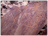 como património Mundial. como património Mundial.
Do ponto de vista económico, o tecido empresarial da região é composto, na sua maioria, por microempresas (em 2001, cerca de 89% das empresas tinham menos de 10 trabalhadores) existindo pouca representatividade de empresas que empregam mais de 50 trabalhadores (menos de 2%).
A agricultura de subsistência foi dando lugar à indústria e serviços, tendo existido em tempos grandes unidades ligadas à indústria automóvel e têxtil. Hoje, devido à crise no sector quase desapareceram, subsistindo, salvo raras excepções, as pequenas e micro empresas.
O turismo é também uma aposta da região, nomeadamente no concelho Guarda, onde vários hotéis aproveitam a proximidade com a Serra da Estrela.
Nesta zona da Beira Interior, ainda vão resistindo alguns bosques de frondosos pinheiros, nomeadamente na zona de Pinhel, cujo nome deriva precisamente destas árvores.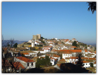
A gastronomia da região é muito diversificada, devido aos inúmeros produtos agrícolas que por aqui se vão produzindo, desde o vinho à azeitona, passando pela castanha, cevada, centeio, amêndoa, entre muitos outros. Das muitas iguarias, destaca-se o Caldo de Grão, Sopa de Beldroegas, Migas, Bacalhau à Lagareiro, Cabrito Assado, Torresmos, Cavacas Doces, Pão-de-ló e o Arroz Doce, sem esquecer os enchidos, nomeadamente a Chouriça.
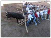
Na zona da raia (Sabugal) predomina ainda a festa brava, ou festa dos touros, designada por “Capeia raiana”, em que os touros são lidados com uma estrutura de madeira, chamada de “forcão”, manejada por vários homens.
 A Guarda, enquanto cidade mais importante, é conhecida como a cidade dos 5 F’s: Forte, Farta, Fria, Fiel e Formosa. O ar, historicamente reconhecido pela salubridade e pureza, foi distinguido pela Federação Europeia de Bioclimatismo em 2002, que atribuiu à Guarda o título de primeira "Cidade Bioclimática Ibérica". É a cidade mais alta de Portugal, quanto à altitude da área urbana do município, com altura média de 1.056m. O clima da cidade é temperado, com relativa influência mediterrânea, visto que no verão há uma curta estação seca. Os meses mais quentes são Julho e Agosto, com temperatura média de 17°C, e o mês mais frio é Janeiro, com média de 3°C. Também Janeiro é o mais chuvoso, com pluviosidade média de 241mm, e o mais seco é Agosto, com média de escassos 15mm. A temperatura média anual é de 10°C e a pluviosidade média anual é de 1.713mm. É considerada uma das cidades mais frias de Portugal, chegando a experimentar alguns dias do ano com precipitações de neve. A Guarda, enquanto cidade mais importante, é conhecida como a cidade dos 5 F’s: Forte, Farta, Fria, Fiel e Formosa. O ar, historicamente reconhecido pela salubridade e pureza, foi distinguido pela Federação Europeia de Bioclimatismo em 2002, que atribuiu à Guarda o título de primeira "Cidade Bioclimática Ibérica". É a cidade mais alta de Portugal, quanto à altitude da área urbana do município, com altura média de 1.056m. O clima da cidade é temperado, com relativa influência mediterrânea, visto que no verão há uma curta estação seca. Os meses mais quentes são Julho e Agosto, com temperatura média de 17°C, e o mês mais frio é Janeiro, com média de 3°C. Também Janeiro é o mais chuvoso, com pluviosidade média de 241mm, e o mais seco é Agosto, com média de escassos 15mm. A temperatura média anual é de 10°C e a pluviosidade média anual é de 1.713mm. É considerada uma das cidades mais frias de Portugal, chegando a experimentar alguns dias do ano com precipitações de neve.
Pela sua proximidade com Espanha e pelas inúmeras fortificações existentes, é, pode dizer-se, uma região intimamente ligada à história de Portugal, e é precisamente este o elo, que o levará a mais uma etapa da cache “LUSITANI”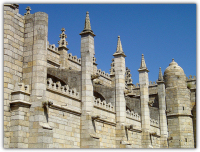
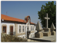
Trata-se dos vestígios de um castro a que se juntam as ruínas da vila de Jarmelo, onde um dos executores de Inês de Castro, Pêro Coelho, tinha um solar, e que por isso foi mandada arrasar por Pedro, “o Cru”, quando subiu ao trono. O castro engloba duas cinturas defensivas, a primeira das quais é delimitada em todo o seu perímetro por muralha de aparelho irregular e de grande espessura. No flanco leste encontra-se um troço que integra uma crista de afloramentos rochosos de grandes dimensões, correspondendo ao local onde talvez se situasse o castro lusitano. No ponto mais alto, onde se ergue um marco geodésico, terá existido a antiga torre de menagem. Nesta área encontram-se também as ruínas da Igreja de Santa Maria, da Fonte da Moura, do casario, vestígios de uma calçada romana e várias sepulturas escavadas na rocha.
[EN]
 The “Beira Interior Norte” is a Portuguese statistical sub-region, integrant part of the Center Region and “Guarda” District. It limits north with “Douro”, east with Spain, south with “Beira Interior Sul” and “Cova da Beira”, and west with “Serra da Estrela” and “Dão-Lafões”. Has a total area of 4.251 km² and in 2001 registered a population of 115.326 units. It is composed by 9 sub-regions: “Almeida”, “Celorico da Beira”, “Figueira de Castelo Rodrigo”, “Guarda”, “Manteigas”, “Mêda”, “Pinhel”, “Sabugal” and “Trancoso”. Of these are citys: “Guarda”, “Pinhel”, “Trancoso”, “Mêda” and “Sabugal”. The “Beira Interior Norte” is a Portuguese statistical sub-region, integrant part of the Center Region and “Guarda” District. It limits north with “Douro”, east with Spain, south with “Beira Interior Sul” and “Cova da Beira”, and west with “Serra da Estrela” and “Dão-Lafões”. Has a total area of 4.251 km² and in 2001 registered a population of 115.326 units. It is composed by 9 sub-regions: “Almeida”, “Celorico da Beira”, “Figueira de Castelo Rodrigo”, “Guarda”, “Manteigas”, “Mêda”, “Pinhel”, “Sabugal” and “Trancoso”. Of these are citys: “Guarda”, “Pinhel”, “Trancoso”, “Mêda” and “Sabugal”.
This is a very vast zone, situated in the north interior of the Country and with a long border with Spain. Given to his extension, the profile varies, being affected to south, near “Guarda”, by the “Serra da Estrela” mountain, and to north mainly by the “Côa” river. By that, is constituted mainly by plateaus, normally width 600m above the sea level, exceptionally south, where the rivers “Mondego” and “Zêzere” had excavated big valleys, and north with the “Marofa” mountain. This is a zone with an aged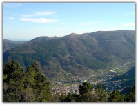 population and with low level of schooling. This aged population problem assumes, in “Beira Interior Norte”, worrying proportions, especially in those geographically interior regions, where “Guarda” appears as the “youngest” region of all. population and with low level of schooling. This aged population problem assumes, in “Beira Interior Norte”, worrying proportions, especially in those geographically interior regions, where “Guarda” appears as the “youngest” region of all.
It is a region with a big monumental wealth, with many and varied Roman-castles called “castros” and castles, some of those are represented in the 5 shields of the Portuguese flag. One example is the castle of “Sortelha”, near “Sabugal”. It is a zone where granite, sandstones, limestone’s and shale’s are mixed and coexisting witch other. It is precisely in a shale area that you can find the famous engravings from the “Côa” valley, the most important complex of Paleolithic art outdoor known until today, classified like World patrimony.
From economical point of view, the region is composed, in his majority, by small businesses (in 2001, around 89% of the companies had less than 10 workers) existing few companies that employ more than 50 workers (less than 2%).
The agriculture is annually being substituted by industry and services companies, some related with car and textile industries. Today, due to the sector crisis they barely disappeared, subsisting, save rare exceptions, the small and micro companies.
 The tourism is also a bet, mainly in “Guarda”, where several hotels take advantage of the proximity with “Serra da Estrela” mountain. The tourism is also a bet, mainly in “Guarda”, where several hotels take advantage of the proximity with “Serra da Estrela” mountain.
In this region, pine trees forests still go resisting, namely in the zone of “Pinhel”, whose name drift precisely from these trees.
The region gastronomy is a lot diversified, due to the endless number of agricultural products produced, mainly wine and olive, but also chestnut, barley, rye and almond, between many others. From regional cuisine he can highlight the “Caldo de Grão”, “Sopa de Beldroegas”, “Migas”, “Bacalhau à Lagareiro”, “Cabrito Assado”, “Torresmos”, “Cavacas Doces”, “Pão-de-ló” and “Arroz Doce”, with out forget the famous sausages, mainly the thin sausage.
In the “Raia” (ray) zone near “Sabugal” still predominates the brave party, or party of bulls, named by "Capeia raiana", in that, the animal are deal with a structure of wood, called "forcão", handled by several man.
“Guarda”, the most important city from “Beira Interior Norte”, is known as the city of the 5 F's: Strong (Forte), Full (Farta), Cold (Fria), Faithful (Fiel) and Taiwan (Formosa). The air, historically recognized by its salubrity and purity, was distinguished by the European Federation of Bio-clime in 2002, with the title of first "Bio-Climatic Iberian City". It’s the higher city of Portugal, regards the altitude of the urban area, with medium height of 1.056m. The city climate is temperate, with relative Mediterranean influence with a short and dry summer. The hottest months are July and August, with medium temperature of 17°C, and the coldest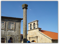 month is January, with medium of 3°C. Also January is the rainiest one, with mediums of 241mm, and the driest one is August, with mediums of 15mm. The annual medium temperature is of 10°C and to rainfall an annual medium of 1,713mm. It is considered one of the coldest cities of Portugal, with precipitations of snow in some days of the year. month is January, with medium of 3°C. Also January is the rainiest one, with mediums of 241mm, and the driest one is August, with mediums of 15mm. The annual medium temperature is of 10°C and to rainfall an annual medium of 1,713mm. It is considered one of the coldest cities of Portugal, with precipitations of snow in some days of the year.
By his proximity with Spain and by the countless existing fortifications, is, he can say, a region strongly connected with Portugal history, and is precisely this, the link that takes you to another "LUSITANI" stage cache.
The Cache is near of the vestiges of a Roman-castle joined with the ruins of “Jarmelo” town, where one of the executors of “Inês de Castro”, “Pêro Coelho”, had a manor-house. That’s why “Pedro o Cru” ordered the devastation of that town, by the time he raises up to the Portuguese throne. The Roman castle vestiges embodies two defensives waists, the first one is delimited in their entire perimeter by irregular wall of big thickness. In the flank east finds-itself little part of outcrop rocky crests with huge dimensions, corresponding to the place where perhaps was situated the “Lusitani” Roman Castle. In the higher point, where is raised a geodesic landmark, will have existed one big tower. In this area also exists the ruins of the Holy Mari Church, vestiges of Roman sidewalk and some rock excavated graves.
Bibliografia:
- netcentro.pt
- Wikipédia – A enciclopédia Livre On-Line.
- “Portugal Património”, 4º volume, de Álvaro Duarte de Almeida e Duarte Belo, editado pelo Círculo de Leitores
|
Altitude - 944m

[PT] A Cache
Esta cache vai levá-lo até à antiga vila do Jarmelo e ao seu núcleo histórico. Ali poderá visitar as capelas de S.Miguel e S.Pedro, a Casa Museu, o imponente minarete/marco geodésico, um conjunto escultórico representando a morte de D. Inês de Castro entre outras coisas. Para relaxar descanse no pequeno auditório da Casa Museu e fique a conhecer as vacas do Jarmelo, uma raça única no mundo e em vias de extinção.
O caminho para a cache parte do Waypoint abaixo indicado em direcção a Nordeste.
A cache é uma vulgar caixa de plástico com os objectos habituais. Por favor deixe-a exactamente onde e como a encontrou.
Dentro da cache, além dos objectos habituais, vai encontrar uma folha especial com um número (Ligada ao LogBook). Por favor anote este número e o nome da cache. Juntando todos os códigos das 30 caches parciais, conseguirá obter as coordenadas da localização da cache final Lusitani, que está escondida algures em Portugal.
Para dúvidas ou esclarecimentos relativos ao projecto global das caches Lusitani, pode contactar os responsáveis pelo projecto: GeoDuplaP&F
[EN] The Cache
This cache will take you to the old town of "Jarmelo" and to his historical nucleus. There you can visit the chapels of "S.Miguel" and "S.Pedro", the home Museum, the great geodesic landmark, a group of sculptures representing the death of “D. Inês de Castro” between other things. For relax you can rest in the small audience of the home Museum and know the cows of the “Jarmelo”, an unique race in the world and on the point of extinction.
The trail to the cache begins at the Waypoint indicated below, direction Noreast.
The cache is an ordinary small box with the usual objects in it. Please leave it well hidden as was.
Inside the cache, besides the usual objects, you'll find a special sheet with a number (attached to the logBook). Please note this number and the cache name. Keeping together all 30 partial caches codes, you'll get the way to find the coordinates of the final Lusitani cache, which is hidden somewhere in Portugal.
If you have any doubt or need any clearing about the Lusitani cache project, you can contact the project developers: GeoDuplaP&F

Conteúdo inicial: 6 peças de Lego e uma fita com as cores de Portugal.
|
Lusitani vizinhas » | Douro | Beira Interior Sul | Cova da Beira | Serra da Estrela | Dão Lafões | « Neighboring Lusitani
|