
Mima Mounds Natural Area Preserve represents about 3% of a prairie system that used to stretch for over 20 miles. “Pimpled Plains” similar to this one exist in a few other places in the US, and on several other continents as well. All of these places have a different geological past, which adds to the mystery of the origin of the mounds.

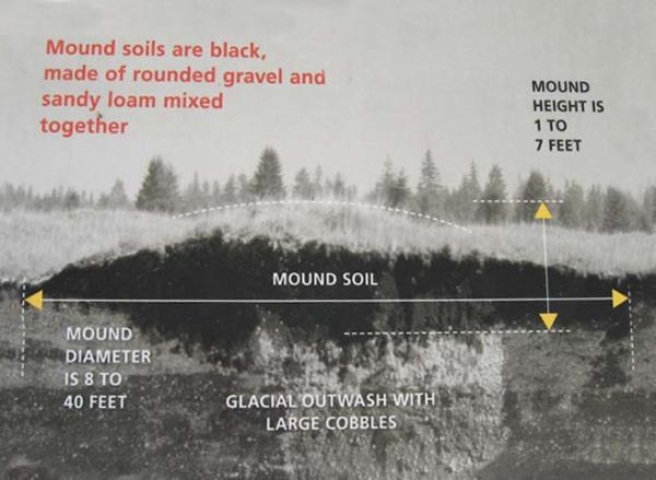
Here in South Puget Sound, the mounds are located only on top of layered sediment deposited by glacial meltwater. A cross section of one of the mounds reveals black sandy loam mixed with rounded gravel on top of a deep layer of glacial outwash with large cobbles.
Theories abound for the origin of the Mima Mounds. They include:
Glacial Ice
In 1913, geologist J. Harlan Bretz concluded that gravel, stones, and soil washing into a melting ice age glacier might have collected in pits called suncups. As the ice melted, the sediment pits settled into rounded shapes.
Earthquakes
Andrew Berg suggests that mounds might form when earthquakes generate vibrational shock waves that travel through the soil.
Sediments from an Ancient Flood
Some scientists have proposed that the mounds are made of deposits from sediment rich floods from a glacially dammed lake.
Erosion
Runoff from glacial meltwater eroded the soil between trees or shrubs, leaving mounds around the plants.
Pocket Gophers
When the glaciers retreated, pocket gophers populated the area. As they attempted to dig nest chambers, they encountered the dense layer of glacial debris under the soil. They moved soil and pebbles upward, forming a mound. Since pocket gophers are territorial, this theory concludes that the center of each mound represents the center of a pocket gopher’s territory.
Cracking Permafrost
Permafrost at the end of the glacial area cracked into many-sided shapes. Ice formed wedges in the cracks. As the climate warmed and the ice melted, the soil was left in rounded shapes.
Man-made Agricultural Mounds
Local indigenous people built them to improve drainage for growing crops.
Sea of Stumps
They are the remains of decayed stumps from an ancient forest
Paul Bunyan
Paul Bunyan made the mounds while digging out Puget Sound to transport logs to lumber mills.
Or...
Paul Bunyan wanted to build a wall like the Great Wall of China to protect his country. The Irishmen he hired to do the work dug a great hole (Pacific Ocean) and erected much of the "Wall" (Cascade Mountains) before quitting because they didn't like the food. Before walking off the job, they dumped their wheelbarrows, creating the Mima Mounds.
Ancient Fish Nests
Tsunami
Flooding due to giant Tsunami generated by an asteroid impact at sea.
Created by Aliens
as a form of communication
Indian Burial Mounds
No human remains have ever been found inside one of the Mima Mounds.
Worm Poop
Earthworms deposit their waste at the ground surface. Could they have communal favorite latrines?
Vegetation Spatial Patterning
Individual plants or groups of plants spread their roots and drain surrounding areas of water and nutrients, while the soil in which they grow remains fertile. Resources become depleted between the vegetation patches and accumulate on the patches, essentially setting up islands of fertile areas that are regularly spaced out across a large region.
None of these theories have ever been proven.
Logging Requirements
1. Go to the posted coordinates and view the mounds from the upper level, if possible.
2. State in your online log which of the theories you think is most likely responsible for the origin of the mounds.
3. Make an estimate of the diameter and height of the mounds, and email that estimate to me. Do not post your estimate in your log, and do not simply copy down the size range given in the cross section. Tell me how big you think the mounds you see in front of you are.
4. Take a walk at least partway around the paved trail that loops around through the mounds. Take a photograph of yourself and your GPSr among the mounds, and post the photo with your log. This is a sensitive area - do not step beyond the paved trail.
Read the logging requirements carefully! The size estimate gets emailed to me, and the origin theory goes in your log. Logs that don't follow the instructions will be deleted.
Sources:
The Seattle Times
Washington State Department of Natural Resources
Science Frontiers, Mounds of Mystery
Perigee: Zero
The Seattle Times April 3, 2009