Guler Ice
Caves
 |
|
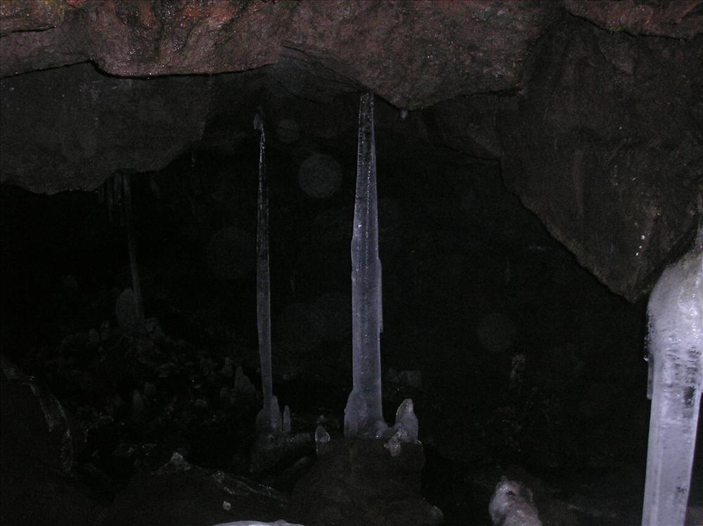
Get ready to explore the
Guler Ice Caves. Photo by James Loaris.
|
If you enjoy doing a little spelunking, you might take a trip up
to Trout Lake, Washington. It is there you will find the
Guler Ice Caves. These underground chambers are
not too large or deep, making them a fun experience for the novice
spelunker.
Take Washington Route 141 north from White Salmon to Trout Lake,
then head west on Forest Road 24 for 5.5 miles. While the cavern
isn't very long - only 650 feet - the footing is rocky and without
sturdy shoes it would be easy to twist an ankle. Portions of the
Ice Caves are inaccessible, but you can find other sinkholes by
following a surface trail. There are restroom facilities in the
parking lot.
The entrance is over some sizeable rocks. Slip through the
crevice in the ground and you will find the temperature drops
dramatically. Even in the heat of summer, the temperatures in the
Ice Caves can be quite chilly. In fact, the cool temperatures of
the cavern are what made this such an amazing discovery to the
settlers of the Columbia Gorge.
The year was 1860, and pioneer traveler R. W. Reynolds noticed a
curiosity: the taverns and fancy hotels of Portland served
disgusting, tepid drinks in the heat of the summer, but their
counterparts in the rough-and-tumble town of Dalles City
(today’s The Dalles) offered “civilized mixed
drinks” properly chilled with a summer rarity: ice
.Determined to find the mysterious source of mid-summer ice,
Reynolds boarded a steamer to the mouth of the White Salmon River,
then rode horseback some 40 miles to the Trout Lake wilderness,
where he found the secret source of ice for pioneers and Indians
alike — Guler Ice Caves, one of many lava tubes that riddle
the rocky landscape beneath the Gifford Pinchot National Forest
like Swiss cheese. Source: Klickitat Genealogy
and History Research, Trout Lake Area http://homepages.rootsweb.com/~westklic/tlhistry.html
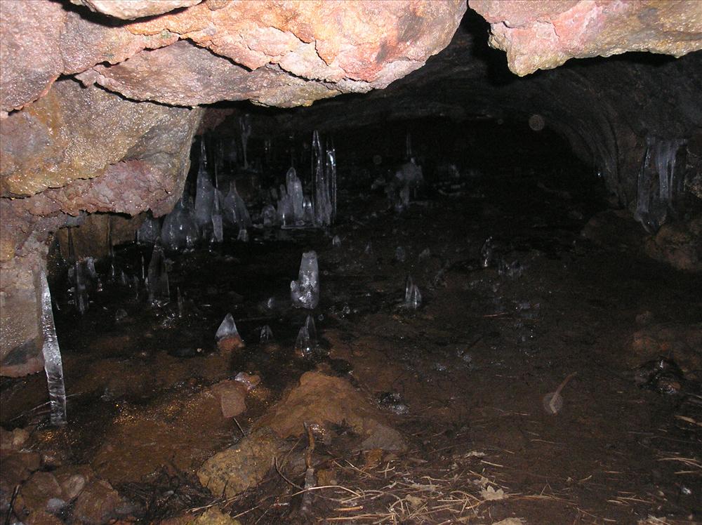 |
Inside one of many Ice Caves
|
Guler Ice Cave is less than 20,000 years old, according to
authors Marge and Ted Mueller, writing in “A Guide to
Washington’s South Cascades’ Volcanic Landscapes”
(The Mountaineers, 1995).That makes it a youngster in Columbia
Gorge geology, where lava flows range anywhere from one to 15
million years old. Lava tubes are formed of
“pa-hoe-hoe” smooth basalt: since basalt is an
excellent insulator, liquid basalt can flow for many miles after
its surface crusts over. But the channels eventually narrow and the
basalt solidifies, leaving vacated passageways; these become
accessible when the roof collapses. Source of the lava, in this
case, was a crater vent in Indian Heaven Wilderness. Now partially
filled with water, it’s called Lake Wapiki. And while
you’re toolin’ around the “GP” National
Forest, check out a few other basaltic oddities — the Natural
Bridges near Mt. Adams, and Big Lava Bed south of Goose Lake. Stop
by the Mt. Adams Ranger Station in Trout Lake for details.
Source: The Dalles
Chronicle
From the History Archives
(Editor's note: You will note a discrepancy between reports
of the "discovery dates" of these caves. One should keep in mind
that the caves were, in fact, "discovered" by the Native Americans
who have lived in the area for centuries. The Native Americans used
to use the caves, which are located a short distance from the
huckleberry fields on Mt. Adams, to keep their summer harvest of
huckleberries fresh.)
Lava Caves Near Guler Natural Cold
Storage For Fruits And Vegetables
DATELINE - WHITE SALMON ENTERPRISE, 1928 - The Oregonian's
automobile editor recently made a trip to Guler and had a big page
write-up of the White Salmon-Trout Lake country, illustrated with
large pictures. Christian Guler proved to be a fine source of
information to the automobile editor, and in telling about the big
lava cave near Guler said: "Two boys discovered the cave a long
time ago," explained the host. "They saw a small hole in this lava
protrusion, dropped a stone through and knew it was a cave. The
present opening was blasted out. They found the cave extended 200
yards west and half mile east and south. It makes a right angle
turn. Scientists say it was formed by gases in the molten lava
spewn out long ago, probably from Mount Adams." He lighted two gas
lamps and we dropped into fearful darkness and into the cold. A
towering framework has been constructed in the immense cave, tiers
running for perhaps 100 yards along the eastern portion of the
recess. Here, on these supports, made gaunt by shadows from the
white gas light, were sacks and boxes of Yakima potatoes. Mr. Guler
picked up several of the tubers. "Here, feel of them. They are as
firm as the day we put them in the cave. Not a sprout. A roof over
the framework keeps the cave drippings from the spuds. We have some
strawberries in here to see how long they will keep and forest
service is experimenting with dried fruits. A conveyor belt will be
installed and this fall apple growers from White Salmon will store
their apples here. It's cheaper for them to haul them to the cave
than to pay for artificial refrigeration. The cave's big enough to
store the produce of the whole valley." It seemed to us, as we
climbed out of the chill air into the sunlight, that W. H. Dean of
White Salmon and Charles Coate of Husum, who control the cave, have
found a gold mine in this gloomy yet fascinating hole in the
ground.
Source: The
Enterprise, White Salmon, WA., June 15, 1928, page 1
Lava Caves
The Lava Caves, one mile west of the Mt. Adams Ranger Station on
the Carson-Guler Road, were first discovered by Jack Aerni in the
summer of 1895. Since that time geologists in the Mt. Adams
district have investigated the subterranean channels and expressed
the opinion that all the lava flow between East Crater and the
location of this main chamber is interspersed with smaller caverns.
This was caused by the lava flowing over water and the outer crust
of the flow cooling much faster than the core. Thus the center
flowed away leaving these chambers. The main Lava Cave chamber
extends for almost three-quarters of a mile in a southeasterly
direction, and varies in height from six to forty-five feet, and
from twelve to twenty-two feet in width. The ceiling is quite
symmetrical, smooth-washed rock which juts from sandy floors. The
main cave chamber veers from a north and south direction, turning
southeast, at which point may be seen the "pillars", dividing that
end and making two separate chambers. In 1928 new steps were put
down through the ceiling, and a house was built over the opening by
W. H. Dean, who experimented is using this place for a storage
cellar for potatoes and cheese. It was found that for commercial
uses these two products would keep very satisfactorily, However, at
the present time no definite program has been inaugurated, and the
Caves remain open for the general public to visit throughout the
greater portion of the year. Source: The
Sportsman's Guide, published by The Mt. Adams Fish & Game
Association, 1939
How to log this
Earthcache:
- Log your find of this earthcache online, and include a photo of
yourself with your GPS in front (or in) of the main entrance to the
ice caves. Make sure your photo shows everybody in your party who
plans to log this earthcache. You may use more than one photo if
needed. Pasting yourself &/or your GPS into a photo is not
acceptable.
- E-mail me answers to the following two questions: A) Explain in
detail what phenomenon occurs that keeps the cave cold; B) List the
four items suggested to have before entering the cave. (Please make
sure you do not have this sign in your photo posted online)
- As required for Earthcache listings, incomplete
logs will be deleted. An incomplete log is one that does not
include one or more photos (as described above) within a reasonable
amount of time, and an e-mail to me with correct answers to both of
the questions
Congratulations toglobaltreckers
for their FTF
on this cache!