 |
Deutsche Version (English version below): |
Dieser Earthcache führt Euch in die Gauchachschlucht und möchte Euch die geologischen Hintergründe näher bringen. Dazu werdet Ihr an zwei interessante Stellen geführt. Station 1 Eures Spazierganges befindet sich an obiger Koordinate bei N47° 52.380 E8° 26.283 (Hinweis: natürlich könnt Ihr die Schlucht auch in umgekehrter Richtung durchwandern und die Reihenfolge der beiden Stationen umkehren). Beantwortet dort die Frage (s.u.). Anschließend begebt Euch zu N47° 52.086 E8° 26.234 und macht dort ein Foto von Euch vor der Schluchtkulisse sowie der Brücke. Plant ein, dass der Weg vom Parkplatz zur zweiten Station knapp 4 Kilometer beträgt. Nehmt entsprechend Proviant mit und berücksichtigt, dass Ihr auch wieder zurück müsst. Ich selbst empfehle Euch, dem Weg weiter zu folgen und auch noch durch die Wutachschlucht zu gehen (entsprechend des Gauchach/Wutach Wandercaches).
Die Gauchachschlucht
Die Gauchachschlucht wird nicht so häufig besucht und ist auch an schönen Tagen kaum überlaufen. Die Gauchach entspringt südlich von Oberbränd, fließt bei Dittishausen und an Döggingen vorbei und mündet oberhalb der Wutachmühle in die Wutach.
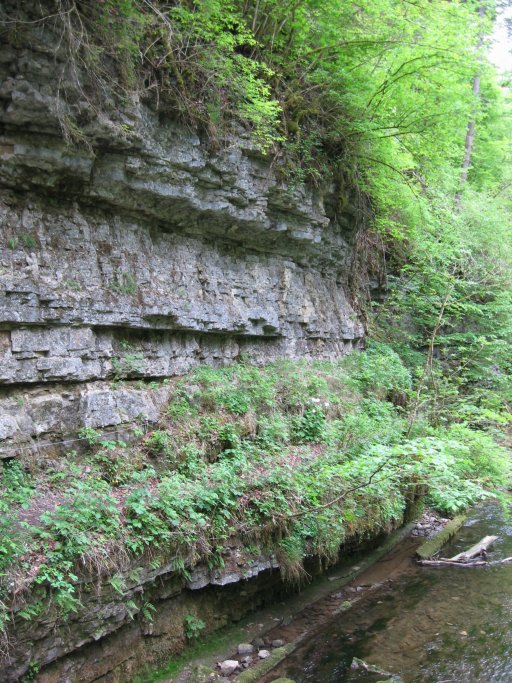
Die eigentliche gut 4,5 Kilometer lange "Gauchachschlucht" beginnt aber erst unterhalb von Döggingen, wo sich der Bach tief in das harte Muschelkalkgestein gefressen hat. Die Schlucht ist wegen der steilen Hänge und des schwierigen Zugangs in einem naturnahen Zustand geblieben. Die Hänge sind großenteils von Schluchtwäldern bedeckt. Sie ist die wichtigste Nebenschlucht der Wutachschlucht und durch ihre Enge sowie durch ein in Bänken des Oberen Muschelkalks treppenartig geformtes Bachbett gekennzeichnet. Etwa in der Mitte mündet an der Burgmühle die recht geradlinige, lange Engeschlucht des Tränkebachs, die mit der Gauchach- und der Wutachschlucht das Bachheimer Schluchtenviereck bildet. Auch dort findet der Niedrigwasserabfluss seinen Weg unterirdisch zur Wutach. Weitere bekannte Nebenschluchten sind die Rötenbachschlucht und die Lotenbachklamm. Wie diese sind auch viele andere kleine Seitenschluchten durch Wasserfälle gekennzeichnet, weil deren Bäche der Tiefenerosion der wasserreichen Wutach kaum folgen können.

Zum Vergrößern bitte Anklicken / click for enlargement
Geologie der Gauchachschlucht
Die Gauchachschlucht ist durch ein in Bänken des Oberen Muschelkalks treppenartig geformtes Bachbett gekennzeichnet. Der Muschelkalk ist die mittlere der drei lithostratigrafischen Gruppen der Germanischen Trias. Heute wird der Begriff Muschelkalk allerdings nur noch als eine Gesteinseinheit betrachtet. Der Muschelkalkstein gliedert sich in drei Untergruppen:
- Oberer Muschelkalk
- Mittlerer Muschelkalk
- Unterer Muschelkalk
Der Untere Muschelkalk besteht hauptsächlich aus Kalken, Kalkmergeln und Tonmergeln. Der Obere Muschelkalk, der hier von entscheidender Bedeutung ist, ist eine lithostratigrafische Untergruppe des Muschelkalks der Germanischen Trias. Die lithostratigrafische Einheit wird von der Mittleren Muschelkalk-Untergruppe unterlagert und vom Keuper überlagert. Die Ablagerungen des Oberen Muschelkalks dokumentieren vollmarine Verhältnisse und Verbindungen zum Tethys-Ozean. In den östlichen Randbereichen wurden kalkreiche Sandsteine sedimentiert.

Zum Vergrößern bitte Anklicken / click for enlargement
Um diesen Earthcache zu loggen, erfülle bitte folgende Aufgaben:
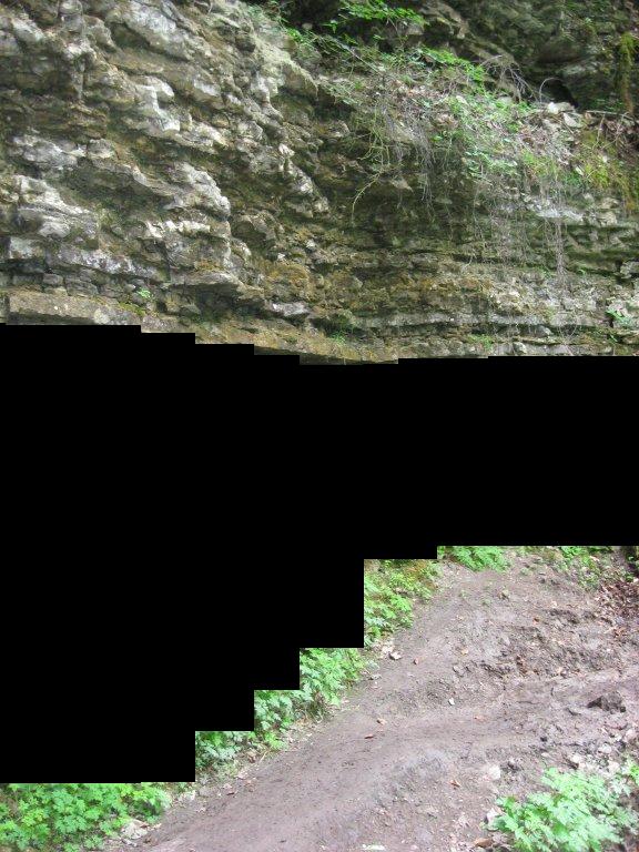
- Zähle bei N47° 52.380 E8° 26.283 die Anzahl der Schichten im Muschelkalk, die ich bei nachfolgendem Foto schwarz übermalt habe. Sende mir die Anzahl per Mail.
Zum Vergrößern bitte Anklicken / click for enlargement
- Mache bitte freiwillig ein Foto von dir vor der Schluchtwand/Brücke bei N47° 52.086 E8° 26.234. Falls du alleine bist, reicht auch ein Foto von deinem GPS mit lesbaren Koordinaten.
Weitere Infos zum Thema können auf folgenden Links gefunden werden:
Wikipedia-Artikel über die Wutachschlucht
Wikipedia-Artikel über Muschelkalk
Touristische Infos
Empfehlung:
Dieser Cache lässt sich super mit einem anderen Cache verbinden, den ich Euch gerne ans Herz lege!
Gauchach/Wutach Wandercache (Lest hier unbedingt die Hinweise auf Streckenführung und Länge sowie plant die Tour sorgfältig!)
 |
English version: |
This earthcache guides you through the Gauchachschlucht and would like to give you an understanding of the geological backgrounds of this area. Therefore you will be directed to two different, interesting locations. Start your walk at the above coordinates. Answer the question there and afterwards go to N47° 52.086 E8° 26.234. Take a photo of you there in front of the rock face/bridge. Please notice that the way from the starting point to the second station is about 4 kilometres through the canyon. So take enough provisions with you.
The Gauchach Canyon
The "Wutachschlucht" is one of the last original wild stream regions in the middle of Europe. Every biologist, geologist and hiker is enthusiastic about its fantastic animal world, the great flora and the terrific geology like a picture book. In the last approximately 70000 years the "Wutach" has dug a deep (200 metres) and long (30 km) valley in the south of the Black Forest. That`s a very short space of time in the history of the earth, the "Wutachschlucht" is thereby the youngest "canyon" of the world. The "Gauchachschlucht" is the most famous small canyon next to the "Wutachschlucht". It is about 4,5 kilometres long.
The Geology
The most significant rock in the canyon is shell limestone (Muschelkalk in german). Muschelkalk is the term in geology for the middle member of the German Triassic. It consists of a series of calcareous, many and dolomitic beds which lie conformably between the Buntsandstein and Keuper formations.
The name Muschelkalk (Fr., calcaire coquillier; concijylien, formation of D'Orbigny) indicates a characteristic feature in this series, viz, the frequent occurrence of lenticular banks composed of fossil shells, remarkable in the midst of a singularly barren group. In its typical form the Muschelkalk is practically restricted to the German region and its immediate neighborhood; it is found in Thuringia, Harz, Franconia, Hesse, Swabia, and the Saar and Alsace districts. Northward it extends into Silesia, Poland and Heligoland. Representatives are found in the Alps, west and south of the Vosges, in Moravia, near Toulon and Montpellier, in Spain and Sardinia; in Romania, Bosnia, Dalmatia, and beyond this into Asia in the Himalayas, China, Australia, California, and in North Africa (Constantine). From the nature of the deposits, as well as from the impoverished fauna, the Muschelkalk of the type area was probably laid down within a land-locked sea which, in the earlier portion of its existence, had only imperfect communications with the more open waters of the period. The more remote representatives of the formation were of course deposited in diverse conditions, and are only to be correlated through the presence of some of the Muschelkalk fossils.
In the German area the Muschelkalk is from 250-350 ft. thick; it is readily divisible into three groups, of which the upper and lower are pale thin-bedded limestones with greenish-grey mans, the middle group being composed of gypsiferous and saliniferous mans with dolomite. The Lower Muschelkalk consists, from below upwards, of the following rocks, the ochreous Wellen Dolomit, lower Wellen Kalk, upper Wellen Kalk (so called on account of the wavy character of the bedding) with beds of Schaumkalk (a porous cellular limestone), and Oolite and the Orbicularis beds (with Myophoria orbicularis). In the Saar and Alsace districts and north Eifel, these beds take on a sandy aspect, the Muschelsandstein. The Middle Muschelkalk or Anbydnite group, as already indicated, consists mainly of mans and dolomites with beds of anhydrite, gypsum and salt. The salt beds are worked at Hall, Friedrichshall, Heilbronn, Stettin and Erfurt. It is from this division that many of the mineral springs of Thuringia and south Germany obtain their saline contents. The cellular nature of much of the dolomite has given rise to the term Zellendolomit. The Upper Muschelkalk (Hauptmuschelkalk, Friedrichshallkalk of von Alberti) consists of regular beds of shelly limestone alternating with beds of marl. The predominant type of Muschelkalk in the "Gauchachschlucht" is Upper Muschelkalk.
Zum Vergrößern bitte Anklicken / click for enlargement
To log this earthcache, perform the following tasks:
- Count at N47° 52.380 E8° 26.283 the number of layers in the Muschelkalk, which are behind the black bar in the following photo . Send the number to me!
Zum Vergrößern bitte Anklicken / click for enlargement
- Please take optional a photo of you in front of the rock face/bridge at N47° 52.086 E8° 26.234. If you are there without any help, you can take a photo of your GPSr with readable coordinates instead.
