
I read about this location in issue #16 of Weird NJ magazine.
This cache is accessible via trails or steps. Yes, you read that
right. There is a series of stone steps going up the hill.
Here is the text about the steps that used to be on the
information board, as quoted in Weird NJ:
Central to the lot is an extensive set of stone steps,
reputedly laid by engineers and/or scouts for General George
Washington during the Revolutionary War. They facilitated the climb
to the south face of the then denuded top of Watnong Mountain. Here
a massive bonfire was laid as a warning beacon to alert American
troops in the Jockey Hollow area to any strategic movement
undertaken by the British. There seems to be little doubt about the
authenticity of the beacon site.
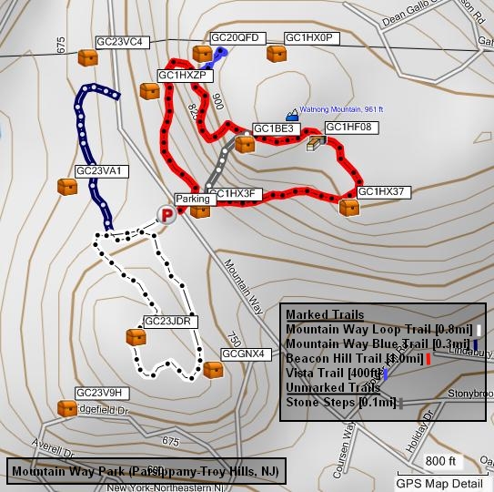
Use the parking lot on Mountain Way. The trailhead is across the
road from the parking lot / playground. At the first fork in the
trail, go to the right. Within fifty feet of the fork, you'll see a
small path to your left leading to the stone steps. The start of
the small path is marked with stone cairns. The cache is within 200
ft of the top step. You'll see a lot of boulders there. Elevation
is approximately 950 ft. The walk should be under 0.2 miles using
the steps.
The cache is also within 200 ft of the trail. At the first fork,
go left for a more challenging climb or right for an easier ascent.
The red trail is one big loop. Near the peak, you'll find a short
blue blazed trail branching off from the red trail. Follow it
towards the power lines for a scenic vista. (not the cache
location, however) Getting to the cache should take a bit over 0.5
miles of walking via the red trail. If you get to the cache site
via the trail and want to see the steps, the top step is at
N40°50.885' W74°29.704'.
The EPE was higher than optimal at the cache location so the
coordinates I read may be inaccurate. If you're having trouble
finding the cache using the given coordinates, please use the hints
and pictures to guide your search.
The cache is an army surplus 50 cal ammo container hidden under
rocks. Please sign and date the log book, and rehide the cache in
its original location once you're done.
Logbook Scans
Log
Book #1 (2003-04-28)
Log
Book #2 (2005-09-09)
Notes: Log Book #1 and Log Book #2 PDF files created from
StayFloopy's original scans hosted at stayfloopy.com.
Mountain Way Park
 This
190-acre municipal park at the far southwestern corner of the town
is also the location of the highest point above sea level in Morris
County, Watnong Mountain. The vistas from the mountain were
important during the Revolutionary War for signaling, and the
detection of troop movements. The posting was then known as Beacon
Hill, and for troops of the Continental Army, had a commanding view
of much of north Jersey; looking north, east, and south, from its
slopes. Though charcoal remnants of the beacons left in the soil
(think the movie Lord of the Rings) have long since been displaced
by human activity, stone steps up the southwest side of the hill
that were built by the Continental Army are still there for
climbing and exploration.
This
190-acre municipal park at the far southwestern corner of the town
is also the location of the highest point above sea level in Morris
County, Watnong Mountain. The vistas from the mountain were
important during the Revolutionary War for signaling, and the
detection of troop movements. The posting was then known as Beacon
Hill, and for troops of the Continental Army, had a commanding view
of much of north Jersey; looking north, east, and south, from its
slopes. Though charcoal remnants of the beacons left in the soil
(think the movie Lord of the Rings) have long since been displaced
by human activity, stone steps up the southwest side of the hill
that were built by the Continental Army are still there for
climbing and exploration.
The Continental Army had plenty of
stones to choose from, as the mountain is a classic example of
terminal moraine, the geological formation of earth and rock pushed
up at the limit of a glacier's advance. The steps are clearly
visible from the southern loop of the 1.1 mile Beacon Hill Trail,
as one enters the mountain side of the park from the parking and
playground area on Mountain Way, and taking the path to the right.
Clearly blazed, other glacial rock outcroppings dot the trail as it
circles south, east, and then north, passing west of the base of
the water tower at the top of the mountain. Continuing north, a
side trail leads to the tree line at the north side of the park,
where an overlook provides a broad view of Sussex, Morris, Passaic,
and Essex counties. For the spry, a shorter hike jogs to the
overlook via the north loop of the trail on the left, but expect a
very slight bit of difficulty as you make your way up. The reward
for taking this more difficult path is the view of some of the most
dramatic outcroppings of glacial boulders, and rockfalls, in the
park.
Reference: Rushing Water
Places by Weldon Monsport