This EarthCache highlights a lesser known unique geological feature
within the Hocking Hills region. This EarthCache was developed
under special permit from the Ohio Department of Natural Resources,
Division of Forestry. This cache is open Daylight Hours Only
and the Collection of Specimens, Either Biological, Cultural, or
Mineral is Strictly Prohibited. No bikes or off-road vehicles
permitted, horses allowed (please follow bridle trail etiquette).
Please see trail map by clicking here.
Remember as always, Leave No Trace.
Parking (included as a child waypoint) is available at
the
Rock Climbing and Rappelling Area Parking Lot at N 39° 27.533, W
082° 33.511.
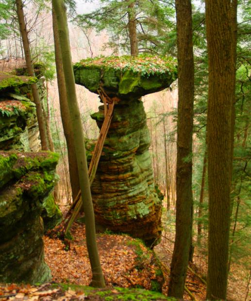 Balanced Rock
The Hocking Hills region has some of the more diverse geological
settings in Ohio. From the highest elevations to the deeper valley,
there are four types of rock exposed. The hills in the area are
topped with the Pennsylvanian-age Pottsville group. The sloping
valley walls are formed of Mississippian-age Logan formation and
Black Hand sandstone from the Cuyahoga formation. This formation is
comprised of a mixture of layers of the harder sandstones,
siltstones, and limestones and the softer shales and mudstones.
Finally the deeper valleys in the region contain Cuyahoga formation
shales.
The Hocking Hills region has limited to no glacial till so it is
suggested that the pre-Illinoian, Illinoian, and Wisconsinian ice
sheet did not encroach on it. However there are limited areas were
lake sediments and Wisconsinian outwash is present. The streams in
the area were dependant upon the advance or melting back of the
glaciers and would have been free to carve into the landscape of
the past couple of million years.
The spectacular features that draw visitors to the region are the
results of the differential weathering of the Black Hand sandstone.
Here the differential weathering agents include stream, freeze and
thaw action, groundwater, gravity, wind, and the natural differing
resistance of the rock strata. Depending upon which strata were
present, the hard sandstone, siltstone, and limestone or the soft
shale and mudstone, the steams in the area had an easy or a
difficult time down-cutting or eroding the streambed and underlying
rock. Also as ground water percolated through these layers, it
either dissolved or hardened the cement of the various grains
holding the rock. Hard strata became waterfalls that continued to
move upstream as the underlining layers of softer strata were
eroded. Thus undercutting the harder layers where the overlying
would break off along joints. This would create a rock-walled
gorge. This process repeated over millions of years has created the
diverse landscape of the area.
Balanced Rock was originally part of the neighboring cliff.
Over time, differential weathering undercut the softer layers of
strata allowing it to slump away along a weaker joint. The strata
of Balanced Rock contains differing degrees of hardness. The softer
base of Balanced Rock eroded more quickly than upper more resilient
top. Thus giving us this unique geological feature to admire for
many more years. However differential weathering is continually
occurring and will undercut Balanced Rock and one day it will be
more no.
To claim a find, please email me the answers
to the questions below. Also you will need to upload a
picture of yourself holding your GPSr with Balanced Rock in the
background with your find log. Logs that do not follow the
finding requirements will be deleted.
Question 1: Estimate the height of Balanced Rock.
Question 2: From the nearby cliff, what is the elevation at the
top of Balanced Rock?

Developed by A Platinum EarthCache Master