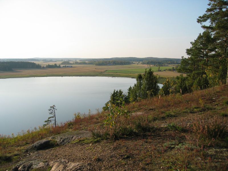
Tämä kätkö vie sinut Anjalassa sijaitsevalle Junkkarinvuorelle. Se on paikkakuntalaisten suosima lenkkeily- ja retkeilykohde, joka länsireunallaan kohoaa lähes pystysuorana n. 45 metriä korkeana jyrkänteenä viereisen Junkkarinjärven rannasta. Jyrkänteen reunalta avautuu upea näköala järvelle ja sen takaisille peltoaukeille ja metsiin. Vuorella saatat ulkoilijoiden lisäksi törmätä myös varjoliitäjiin, jotka liitimillään leijailevat jyrkänteen yllä kohoavien ilmavirtausten kannattelemina. (Katso video tästä. Lisää videoita ja valokuvia täältä.)
Jyrkänteen alla levittäytyvä Junkkarinjärvi on hyvin matala, sen keskisyvyys on vain noin metri ja syvin kohtakin huimat kaksi metriä. Järvi on muuttolintujen suosiossa, mutta virkistyskäytössä sen arvo alkaa rehevöitymisen seurauksena pikkuhiljaa häipyä olemattomiin. Pahasti rehevöityneen järven pelastamiseksi on tehty ensimmäinen kunnostussuunnitelma jo vuonna 1983, mutta sitä ei koskaan toteutettu. Uusimpien suunnitelmien mukaan järvi on tarkoitus kunnostaa tyhjentämällä se kokonaan pariksi vuodeksi, jona aikana pohjamuta tiivistyy ja kovettuu ja näin saadaan järvelle lisää syvyyttä. Tämänkin suunnitelman toteutuminen näyttää epävarmalta, aika kuluu eikä mitään tapahdu.
Kätkö sijaitsee ylhäällä jyrkänteen reunalla, vuoren parhaalla näköalapaikalla. Lisäkoordinaatit (Parkkipaikka A) johdattavat sinut vuoren pohjoispäähän, ränsistyneen ja nyttemmin jo puretun luonnonkelkkaradan parkkipaikalle. Parkkipaikan läheisyydestä löydät myös geokätkön GC3XX1R, Anjalan Liitto 80v. Parkkipaikalta pääset kelkkarataa myöten ylös radan lähtöpaikalle, josta jatkuu polku kohti kätköä. Polku on merkitty maastoon värillisillä nauhoilla. Sen varrelle osuu useiden näköalapaikkojen lisäksi myös "kiitorata", jyrkänteen reunalle viettävä viisto kallionlaki, jota kokeneemmat varjoliitäjät käyttävät lentoonlähtöön. Matkaa parkkipaikalta polkua pitkin kätkölle ja takaisin kertyy noin 2,5 km.
Toinen lähestymisvaihtoehto on kaakosta, Vuorikarinkujan kännykkämastolta (Parkkipaikka B), kulkemalla metsäautoteitä ja polkuja apupisteiden T1 ja T2 kautta. Tämä reitti on maastollisesti hieman helpompi kuin pohjoinen vaihtoehto, mutta kumisaappaita saatat tarvita kesäkuivallakin. Matka kätkölle on suunnilleen saman pituinen kuin pohjoinenkin reitti.
HUOM: Herkkä kallioluonto kuluu helposti, joten kuljethan mahdollisuuksien mukaan vain vanhoja polkuja pitkin. Polut kulkevat paikoin läheltä jyrkännettä, joten ollaanpa varovaisia siellä!
This cache takes you to the Junkkarinvuori hill. It's a popular place for picnic or hiking among local people. It's west side rises almost vertically about 45 metres from the shore of the Junkkarinjärvi lake. Great view opens from the summit; to the lake, and to the fields and forests behind it. Besides the hikers, you may also see paragliders on the hill, hovering above the cliff. (Watch video here. Additional photos and videos can be found here.)
Junkkarinjärvi lake is very shallow, average depth is one metre and even the deepest point is only two metres. Migratory birds use the lake as a resting place, but for recreational activities the lake is not very good because of a heavy eutrophication. First plans for restoration of the lake were made in 1983, but those plans were never carried into effect. Latest restoration plans include draining the lake totally empty for couple of years, for condensing the sediment and that way making the lake deeper.
The cache is located on top of the cliff, on the site of the best view over the lake. Additional waypoint (Parkkipaikka A) takes you to the parking lot of an old natural luge track (which is now demolished). From there you can climb up the hill along the track. From the top you can find the path which is marked with colourful ribbons. That path takes you near the cache. By the side of the path, there are some great views to the lake. There is also a "runway" for the paragliders; slope which leads to the cliff. Distance from the parking lot to the cache and back, along the path, is about 2.5 km.
Another approach is from the south-east. Start from the parking spot near the cell phone tower (Parkkipaikka B) and walk by the trailheads T1 and T2 using forest roads and paths. This approach is little bit easier what comes to the terrain, but you will need wellington boots. Distance is about the same as from the northern parking spot.
ATTN: Sensitive rocky terrain wears easily, so please always use old paths when possible. The paths go near the cliff at some points, so let's be careful out there!