Driving through central
Washington, one can’t help but notice an extraordinary
geological panorama unfolding along the roadways. What most people
fail to realize is that the entire terrain—hillsides, cliffs,
valleys, and canyons—created over millions of years, was
dramatically reshaped by an unusual series of events, which took
place during the end of the last
Ice-Age.
Approximately 17,000 years ago near the end of the Pleistocene
Epoch enormous glaciers covered nearly one third of North America.
The western portion of the glacial ice was known as the Cordilleran
Ice Sheet and the eastern portion as the Laurentide Ice Sheet. East
of the Cascade Mountains, the Okanogan lobe of the Cordilleran Ice
extended south on a line between what is now Chelan and Coulee
City.
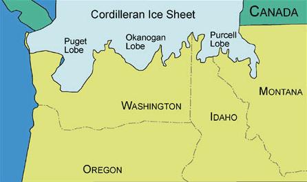
Figure 1. Map showing the extent of the
Cordilleran Ice Sheet,
including the three lobes.
Farther east a lobe
of advancing ice blocked the Clark Fork River at the point where
the river passed through the Bitterroot Mountains. This buildup of
ice blocked the drainage of a large portion of what is now
northwestern Montana. The subsequent backup of water from the
melting glaciers formed an enormous lake known today as Glacial
Lake Missoula. Although we don’t know the eventual height
reached by the ice dam, high water marks on the mountainside
indicate a depth of approximately 2000 feet.

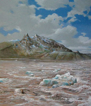
Artist Byron
Pickering's painting of Glacial Lake Missoula.
Exactly what happened
next is still open to speculation; however, evidence shows the ice
dam was eventually breached. When the dam collapsed it permitted
catastrophic flooding of the landscape to the west. With incredible
force, and calculated flood
speeds reaching almost 65 miles per hour, approximately 500 cubic
miles of water and glacial ice burst through the channel gap,
sweeping all before it, as it roared westward. At this rate, the
lake would have drained in only a couple of days.
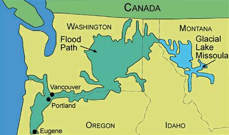
Figure 2. Shows Glacial Lake Missoula and
pathway of the floods.
It is believed the
force of the rushing water was so great a mere four days were
required to drain the entire lake. Today, we can see evidence of
how the floods carved out more than 50 cubic miles of earth,
deposited mountains of gravel, and scattered 200 ton boulders
across the landscape. This astounding process is believed to have
happened not once, not twice, but again and again, possibly as many
as 100 or more times.
The image above is an original painting by
artist, Stev Ominski.
His painting, “Above Wenatchee” depicts the floods
waters at
approximately 1,700 ft above the water level that exists
today.
This massive flow of
water scoured the soil from the landscape, breaking loose enormous
chunks of rock, which it rolled and tumbled along for miles.
Icebergs with incorporated large boulders or “erratics”
floated on the muddy turbulent flood-waters until finding a quiet
resting place sometimes hundreds of miles from their ice dam
origin.
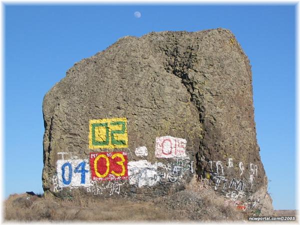
Yeager
Rock (also known as Split Rock)
A glacial
erratic is a piece of rock that deviates from the size and type of
rock native to the area in which it rests; the name "erratic" is
based on the errant location of these boulders. These rocks were
carried to their current locations by glacial ice, often over
hundreds of kilometres. Erratics can range in size from pebbles to
large boulders such as Big Rock (16,500 tons) in Alberta.
Geologists identify erratics by
studying the rocks surrounding the position of the erratic and the
composition of the erratic itself. Erratics were once considered
evidence of a massive flood approximately 10,000 years ago, similar
to the legendary floods described in the texts of ancient
civilizations throughout the world. Ancient legends of an epic
flood come from many cultures including Mesoamerican, Sumerian
(Epic of Gilgamesh), Hebrew (Old Testament) and Indian culture. In
the 19th Century, many scientists came to favor erratics as
evidence for the end of the last glacial maximum (ice age) 10,000
years ago, rather than a flood. Geologists have suggested that
landslides or rockfalls initially dropped the rocks on top of
glacial ice. The glaciers continued to move, carrying the rocks
with them. When the ice melted, the erratics were left in their
present locations.
Just outside of
Mansfield on State Route 172 heading east towards Sims Corner is a
very large rock just sitting on the side of the road. There are
other large rocks sitting out in the flat fields outside of
Mansfield but this one is so large you can't help but stop and take
a look.
The rock, locally
known as 'Yeager Rock' or 'Split Rock' is 400 tons and stands about
three stories high.
To
claim this Earthcache
- Estimate how many feet around the rock is at its
base.
- Share what type of rock you think
it is (example granite, limestone, sandstone, marble, etc.) Hint:
It's not one of the examples listed.
- Do you think this rock was
'rafted' from another location? Why do you think this?
- Take a picture of you and/or your
party at Yeager Rock and post it on the cache page.
- Email the answers to questions 1,
2 & 3 to
Three Bottles
Sources
Geological Society of America
(GSA), 1999 Geologic Timescale, GSA Website, 2006
Laura DeGrey, L and Link, P. Lake Missoula Floods, Idaho
State University.
North Central Washington Portal
(NWC), Yeager Rock, NWC Portal website, 2008
Sims Corner Eskers and Kames.
(2008, February 11). In Wikipedia, The Free Encyclopedia.
Retrieved 00:39, March 14, 2008, from
http://en.wikipedia.org/w/index.phptitle=Sims_Corner_Eskers_and_Kames&oldid
=190733055
Wenatchee Valley Convention and
Visitors Bureau (WVCVB) 2008
Ice age Floods, WVCVB Website, 2008
|