Lake Michigan was formed during the Ice Age as glaciers moved
from the north across the Great Lakes region. As the glaciers
receded large glacial lakes were formed – one of which on early
maps was called “Lake Illinois” and now referred to as “Lake
Michigan” or “The Third Coast”.
Lake Michigan is one of the five Great Lakes and is the only
great lake located entirely within the United States. It has a
surface area roughly of 22,400 square miles. It is 397 miles long
by 118 miles wide with a shoreline of 1,640 miles. The average
depth is 279 feet and the maximum is 923 feet deep. It contains
1,180 cubic miles of water. It is the largest freshwater lake in
the United States and is the world’s fifth largest freshwater lake
(when combined with Lake Huron as they are the same body of water).
Comparing Lake Michigan to the remaining Great Lakes – it is the
third largest. Lake Michigan and Lake Huron are geologically and
hydrologically the same although they are separated geographically
– separated at the Straits of Mackinac.
The water levels of Lake Michigan varies for both short and long
term periods of time.
Long term variations depends on climatology and water storage
over a period of many years. There is an annual high of lake water
during the late spring after the snow melt and spring rains. During
the winter the water levels are lowered due to evaporation of the
warmer water into the colder air and also is the cause of lake
effect snow. The more ice on the lake – the less water is lost due
to surface evaporation. The water level in Lake Michigan can swing
as much as 6 feet in just a few years time. Lake Michigan is so big
that weather patterns from as far back as three years can affect
water levels today.
Short term - water levels can also fluxuate due to the
gravitational pulls of both the sun and the moon. Hhowever, the
change is typically less than 2 inches in height and is very slight
Rapid barometric pressure changes in addition to strong winds from
storms rapidly moving throughout the region (For Example: a storm
moving from the plains to the east coast) can also change the water
levels for short periods of time. As winds cease or may shift
direction it may cause a “seiche”. A seiche is defined as: “A
standing wave oscillation in any enclosed lake which continues
after the forcing mechanism has ceased”. In the case of Lake
Michigan a seiche will move from one side of the lake to the other
side causing fluxuations of possibly several feet much like water
that has been disturbed in a bath tub and rocks back and forth.
Water levels in Lake Michigan effect everyone from small
boaters, marinas, channels, commercial shipping, lakeside property
owners, to large industrial users such as nuclear power plants. The
result of lower water levels in the Great Lakes has a drastic
effect for commercial shipping. They have to haul less product to
avoid bottoming out in low areas. Harbors are also having to be
dredged more often as a result of low lake levels to allow larger
cargo ships access to ports.
Much of the precipitation that enters the ground filters down
into subsurface water-bearing rocks (aquifers) and eventually
reaches stream, rivers (like the Grand River, the Kalamazoo, and
the Fox-Wolf) eventually drain into Lake Michigan. However, water
resulting from snow melting on frozen ground often will evaporate
instead of being soaked into the ground and entering the aquifer
and entering the lake.
Some interesting water facts:
• An average of 70% of the annual precipitation returns to the
atmosphere by evaporation from land and water surfaces in addition
to transpiration from vegetation. The remaining 30% eventually
reaches streams, rivers, lakes, and/or oceans.
• Homes, farms, and industry use about 400 billion gallons of water
per day across the United States.
• One inch of rain falling on 1 acre of ground is equal to about
27,154 gallons and weighs about 113 tons.
• An inch of snow falling evenly on 1 acre of ground is equivalent
to about 2,715 gallons of water. This figure, however, based upon
the "rule-of-thumb" that 10 inches of snow is equal to 1 inch of
water, can vary considerable, depending on whether the snow is
heavy and wet, or powdery and dry. Heavy, wet snow has a very high
water content--4 or 5 inches of this kind of snow contains about 1
inch of water. Thus, an inch of very wet snow over an acre might
amount to more than 5,400 gallons of water, while an inch of
powdery snow might yield only about 1,300 gallons.
• One acre-foot of water (the amount of water covering 1 acre to a
depth of 1 foot) equals 326,000 gallons or 43,560 cubic feet of
water, and weighs 2.7 million pounds.
• One cubic mile of water equals 1.1 trillion gallons, 147.2
billion cubic feet, or 3.38 million acre-feet, and weighs 9.2
trillion pounds (4.6 billion tons).
• 1 inch (gained or lost) in Lake Michigan equals 390 billion
gallons of water. The loss or gain of an inch of water in other
nearby lakes results in:
• Lake Superior 500 billion gallons
• Lake Huron 400 billion gallons
• Lake Erie 170 billion gallons
• Lake Ontario 130 billion gallons

How are water levels measured?
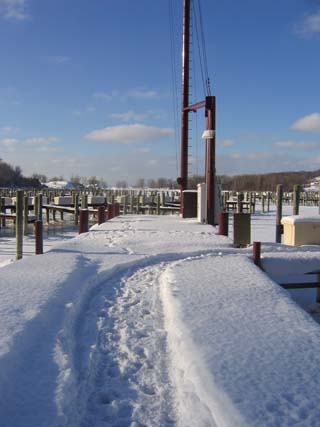
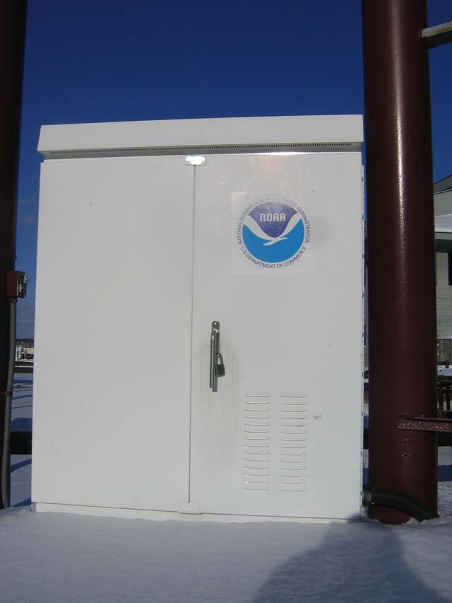
A typical water level station consists of a gauge house mounted
on top of a six foot diameter sump. The house contains the water
level sensors and data collection platforms (DCP). Data are
transmitted hourly via Geostationary Orbiting Environmental
Satellite (GOES). Real-time data are acquired every six minutes by
connecting to the gauge via a telephone modem. In addition to a
primary and secondary water level sensor, some stations also
acquire meteorological data including wind speed and direction, air
temperature, water temperature, and relative humidity.
The primary water level sensor consists of float and a shaft
angle encoder system. The floats rest in wells below the gauge
house. The wells are connected to an intake in the lake or river.
As the water level of the lake or river rises or falls, so does the
water level in the sump. The shaft angle encoder measures how much
the floats move up or down which is used to determine the water
level relative to the datum. The data are stored in the DCP. The
backup water level sensor uses pressure to determine the water
level. The backup water level data are stored in back up DCP. The
Electric Tape Gauge (ETG) is used as a reference gauge and for a
precise check of the primary and backup gauges. The ETG is attached
to a battery and voltage meter. When the bottom of the tape touches
the surface of the water, current is produced. The tape is read and
compared with the primary gauge reading at the same time.

To log this cache:
1) You must visit the site and have your photo with you or your
caching team clearly visible taken next to the water level station
with the NOAA logo visible.
2) You must visit
http://glakesonline.nos.noaa.gov/glin.shtml?station_info=9087031+Holland,+MI
and email me the current height for the lake level at/above/below
LWD (low water datum). FYI - the answer is not 577!
3) Mark a waypoint and observe the altitude of the water sensor and
include that in your email to me.
You may also want to grab the nearby
benchmark.
Any logs that do not meet the above posted requirements
will be deleted at the discretion of the cache owner. All
logging requirements must be completed within 48
hours of logging the cache online or your log will be
deleted unless you have prior permission from the cache owner.