 Parking is in the parking lot of an
abandoned building on the corner. Do not expect beautiful
scenery or such. This is the location of a benchmark
E
584 that was used in a study of land subsidence on the
Oxnard Plain. This study showed that the land settled
approximately 2.6 feet between 1939 and 1978. One of the
primary causes of this settling is thought to be the
over-pumping of ground water.
Parking is in the parking lot of an
abandoned building on the corner. Do not expect beautiful
scenery or such. This is the location of a benchmark
E
584 that was used in a study of land subsidence on the
Oxnard Plain. This study showed that the land settled
approximately 2.6 feet between 1939 and 1978. One of the
primary causes of this settling is thought to be the
over-pumping of ground water.
The demand for water has grown with the population of the Oxnard
Plain. Much of this demand has been met by pumping ground water out
of the various aquifers beneath the area faster than it is
replenished. This has resulted in the lowering of the water table.
In some cases, the level of the water has gone down hundreds of
feet.
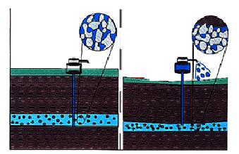 Ground water actually helps keep individual
grains in the ground apart. Once the water is removed, the
grains are compacted closer together by the weight of the
grains above. This decreases the elevation of the area. This
is also a permanent, so even if the ground water level comes
up again, the ground surface does not move. The compaction
also reduces the volume of water that can be stored in the
aquifer.
Ground water actually helps keep individual
grains in the ground apart. Once the water is removed, the
grains are compacted closer together by the weight of the
grains above. This decreases the elevation of the area. This
is also a permanent, so even if the ground water level comes
up again, the ground surface does not move. The compaction
also reduces the volume of water that can be stored in the
aquifer.
You will be taking your own elevation measurement at this
location and comparing it to the benchmark elevation of 17.65 ft
above mean sea level. Currently the benchmark is lost, but it was
in the general area. If you want to find an actual benchmark use
one of the
nearby benchmarks.
For those of you that want to be sticklers for details, the
elevation provided by most gpsr are based on barometric pressure
which changes based on temperature, weather, and various other
factors, so this will not be a detailed scientific measurement, but
it should give you a good idea. To get a better elevation
measurement, you should go to a known benchmark on bedrock,
calibrate your elevation, then come back.
Benchmark Z
583 at N 34° 05.733 W 119° 04.317 and an Altitude: 13.23 is
located on bedrock and was included in the subsidence study
mentioned above. In that study, they found very little subsidence
due to regional tectoncis.
Oil and natural gas extraction also has similar effects. While
not direct factor at this location, the oil fields on Oxnard Plain
have had enough oil and gas extracted to be equivalent the lowering
of the ground water table by 1000s of feet.
Logging requirements:
Send me a note with :
- The text "GC17GBN The Sinking Oxnard Plain " on the first
line
- The number of people in your group.
- With your elevation measurement (be sure to put the gps on the
ground)
- Compare your measurement to the benchmark’s elevation
- Assuming your measurement is accurate, what is the rate of
subsidence at this location since the end of prior study in
1978.
- Based on your answer to 2, do you think over extraction of
ground water is continuing?
The above information was compiled from the
following sources:
- U.S. GEOLOGICAL SURVEY SUBSIDENCE INTEREST
GROUP CONFERENCE, EDWARDS AIR FORCE BASE, ANTELOPE VALLEY,
CALIFORNIA, NOVEMBER 18-19, 1992: ABSTRACTS AND SUMMARY, Keith R.
Prince, Devin L. Galloway, and Stanley A. Leake, editors; U.S.
Geological Survey Open-File Report 94-532, Sacramento, California
1995
- EARTH FISSURES: ARIZONA’S CRACK PROBLEM An
interdisciplinary science module incorporating geological,
chemical, biological, and engineering concepts in the evaluation of
earth fissures. Departments of Physical and Life Sciences Mesa
Community College, December 21, 2001