Kenansville Spring Earthcache EarthCache
Kenansville Spring Earthcache
-
Difficulty:
-

-
Terrain:
-

Size:  (other)
Please note Use of geocaching.com services is subject to the terms and conditions
in our disclaimer.

KENANSVILLE SPRING
HISTORY OF THE KENANSVILLE SPRING
When Duplin County was established in 1750, its residents began looking for a site for the county seat. "Pearsall Cool Spring," as it was known then, was a deciding factor in the selection of Kenansville as the county seat of Duplin.
Capt. James Pearsall, sheriff of Duplin County at the time, owned a large portion of land including what is now Kenansville. He offered to donate four acres of land, including the "Cool Spring," if the authorities would build the courthouse there. The offer was subsequently accepted and the courthouse was built near the spring. This spring of pure water made it a logical choice for the county seat.
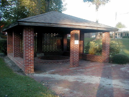
The spring was known to Indians before the white man came. They had a trail near the spring, winding from this locale to the New Bern region. The spring is actually an artesian well, in which underground water is under enough pressure that it flows continuously to the surface. In 1909 it was piped into an overflow and concrete steps built to reach it. A photo made about this time showed a structure with a shingled roof over the overflow and lattice walls to protect it. It is said that later an impatient mule, tied to the wall while his owner got a drink of water, pulled the structure down.
Through the years the spring has functioned in many roles. It afforded water for horse traders and visitors to the courthouse on business. Close to 100 colonists, clustered in homes around the spring at the time of the Revolutionary War, were supplied with water. It was said that the water had medicinal properties and was once bottled and used by residents inside and outside Kenansville. When power lines were down for three days after Hurricane Hazel devastated the area in 1954, residents once again brought buckets and jugs to the spring for their water. Workers in the offices of the courthouse would bring their lunches to work and sit by the spring to eat. Picnics and reunions have been held on the grounds nearby. In addition to furnishing water, the spot has also been the scene of many romantic rendezvous.
According to family lore, the glint of gold on the ground led to the discovery of this sweet water in 1750. As recorded in The History of the Carrs of Duplin County, written by J. O. Carr of Wilmington, NC, in 1920, the spring figures prominently in the history of the CARR family of Duplin County.
According to tradition, a sea captain by the name of Capt. Benjamin Beverett had arrived in the area with his wife Barbara Gastor Beverett and son Jacob. He settled his family near present-day Kenansville, returned to sea, and never returned. Accompanying this family on the same ship were brothers Joseph and William Carr from Ireland. It was later that the widow Barbara married Joseph Carr and they established their home on the north side of the Maxwell Creek area near Kenansville and raised three sons: William, John, and James, who are the ancestors of the Duplin County CARR family.
The legend continues that Barbara was walking with downcast eyes when she saw a goldpiece. Hoping for buried treasure, she began hurriedly scratching the earth with her bare hands, and she uncovered the spring.
Unfortunately in 1994, the water became contaminated by a sewage spill, was deemed undrinkable, and the spring was closed for drinking purposes. It was a sad day for those who loved this landmark.
Since then, through the efforts of many concerned citizens, grants, and the help of the Duplin County Commissioners, there has been renovation of the area into a small park around the spring with picnic tables nearby. This renovation was completed this year 2000 as Duplin County celebrates its 250th anniversary. Even if the water is undrinkable, it has been attractively bricked around, and the water is still flowing in this historic site.
ARTESIAN SPRINGS
Water issuing from an artesian spring rises to a higher elevation than the top of the confined aquifer from which it issues. When water issues from the ground it may form into a pool or flow downhill, in surface streams. Sometimes a spring is termed a seep. Minerals become dissolved in the water as it moves through the underground rocks. This may give the water flavor and even carbon dioxide bubbles, depending upon the nature of the geology through which it passes.
Mineral water is water containing minerals or other dissolved substances that alter its taste or give it therapeutic value. Salts, sulfur compounds, and gases are among the substances that can be dissolved in the water. Mineral water can often be effervescent. Mineral water can be prepared or can occur naturally.
Springs may be formed in any sort of rock. Small ones are found in many places. In Missouri, the largest springs are formed in limestone and dolomite in the karst topography of the Ozarks.
Both dolomite and limestone fracture relatively easily. When weak carbonic acid (formed by rainwater percolating through organic matter in the soil) enters these fractures it dissolves bedrock. When it reaches a horizontal crack or a layer of non-dissolving rock such as sandstone or shale, it begins to cut sideways, forming an underground stream. As the process continues, the water hollows out more rock, eventually admitting an airspace, at which point the spring stream can be considered a cave. This process is supposed to take tens to hundreds of thousands of years to complete.
Each cacher is required to send the required information and not rely on another cacher to provide it. Failure to follow this procedure will result in a deleted log. It is not my job to keep track of your group.
To log this cache, mail me and tell me what you think the magnitude of this spring would be according to the scale below and also upload a photo of you with a GPSr at the spring location with your "Find Log". ,
Springs are often classified by the volume of the water they discharge. The largest springs are called "first-magnitude".
Spring flow scale
1st Magnitude - 100 cubic feet per second (cfs)
2nd Magnitude - 10 to 100 cfs
3rd Magnitude - 1 to 10 cfs
4th Magnitude - 100 gal/min - 1 cfs (448 gal/min)
5th Magnitude - 10 to 100 gal/min
6th Magnitude - 1 to 10 gal/min
7th Magnitude - 1 pint to 1 gal/min
8th Magnitude - Less than 1 pint/min
DO NOT DRINK THE WATER
XXXXXXXXXXXXXXXXXXXXXXXXXXXXXXXXXXXXXXXXXXXXXXXXXXXXXXXXXXXXXXXXXXXXXXXXXXXXXXXX
We became Platinum Earthcache Masters on September 17, 2007.
We were the first to request and receive on July 2, 2011 the Emerald Discovery Award for finding 500 or more Earthcaches.
We received the Diamond Discovery Award on June 17, 2012 for finding 1,000 or more Earthcaches.


XXXXXXXXXXXXXXXXXXXXXXXXXXXXXXXXXXXXXXXXXXXXXXXXXXXXXXXXXXXXXXXXXXXXXXXXXXXXXXX

Additional Hints
(Decrypt)
QB ABG QEVAX GUR JNGRE