Português:
A barragem
de Santa Águeda está localizada no rio Ocreza, um afluente do rio
Tejo, e entrou em funcionamento em 1990.
A barragem
tem a Norte a vista imponente da serra da Gardunha que faz a
separação com a Cova da Beira, a Oeste algumas aldeias, como Póvoa
de Rio de Moinhos, a Este a A23 e a Sul, a cerca de 11 Km, a cidade
de Castelo Branco.
O plano de
água da albufeira de Santa Águeda ocupa uma área com cerca de 634
ha, possui uma capacidade total de 37200 (103 m3) e tem cerca de 35
Km de perímetro.
A sua
superfície alagou uma grande porção de terras de cultivo e floresta
de carvalho, bem como uma antiga ponte romana. A antiga Capela de
Santa Águeda, que deu à barragem o seu nome, ficou também submersa,
existindo hoje uma nova capela.
Concebida
para fornecer água potável à cidade de Castelo Branco e algumas
freguesias do distrito, veio a tornar-se a 'casa' natural de muitas
espécies do reino animal e vegetal que encontraram aqui um lugar
seguro para assegurar a sua sobrevivência. Tornou-se também num
lugar de recreio e lazer para a população de toda a área geográfica
envolvente.
Esta
albufeira é uma das massas hídricas preferidas pelos pescadores da
região de Castelo Branco para a prática da pesca desportiva; quer
de lazer, quer de competição. As espécies predominantes são a carpa
e o achigã.
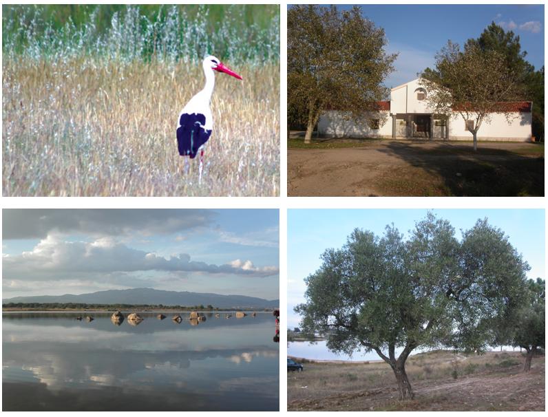
A albufeira
abrange uma área com grande beleza paisagística. Além da vegetação
podemos observar aqui diversas espécies de aves, cuja permanência
varia com a estação do ano. A cegonha branca é um habitante muito
frequente destas paragens. Será importante referir que alguns
casais ficam por aqui ao longo de todo o ano.
English:
The Santa
Águeda Barrage, is located in the river Ocreza, an affluent of the
Tejo River, and entered in functioning in 1990.
In the
north, the barrage has the imponent sight of the Gardunha mountain
that makes the separation with Cova da Beira, in the West some
villages such as Póvoa de Rio de Moinhos, to east the A23 highway
and to South, about 11 km, the city of Castelo
Branco.
The water
plan of the Santa Águeda Barrage occupies an area with about 634
ha, possess a total capacity of 37200 (103 m3) and has about 35 km
of perimeter.
Its surface
flooded a great portion of culture lands and forest of oak, as well
as one old roman bridge. The old Chapel of Santa Águeda, that gave
the barrage its name, was also submerged, existing today a new
chapel.
Conceived
to supply drinking water to the city of Castelo Branco and some
surrounding villages of the district, it became the natural habitat
of many animal and vegetal species that found there a safe place to
ensure its survival.
It also
became a place of recreation and leisure for the population of all
the surrounding geographic area. This barrage is one of the
preferred by the fisher men of the region of Castelo Branco for the
practice of this activity. The predominant species are the carp and
“achigã”.
The barrage
encloses an area with great beauty, beyond the vegetation we can
observe here several species of birds, whose permanence varies with
the season of the year. The white stork is a very frequent
inhabitant of these lands. It is important to refer that some
couples are here throughout all the year.
Como chegar/ How to
arrive:
PT:
Na A23 saia na saída 25: Idanha-a-Nova/ Lardosa. Siga depois as
indicações Barragem de Santa Águeda/ Marateca.
EN:
On the A23 highway take the exit number 25: Idanha-a-Nova/ Lardosa
and than follow the sign to Barragem de Santa Águeda/
Marateca.