Skip to content

De Amersfoortse Kei - Earthcache EarthCache

Hidden : 9/20/2007
Difficulty:
1 out of 5
Terrain:
1.5 out of 5

Size: Size:   other (other)

Join now to view geocache location details. It's free!

Watch

How Geocaching Works

Please note Use of geocaching.com services is subject to the terms and conditions in our disclaimer.

Geocache Description:


 Nederlandse versie


De Amersfoortse KeiVerleden

In het Pleistoceen voor de ijstijden wordt de formatie van Oosterhout gevormd die wordt beschouwd als de hydro-geologische basis van het systeem van grondwaterstanden in de Gelderse Vallei en van de Utrechtse Heuvelrug. Hierop worden klei en zand uit diverse opeenvolgende perioden afgezet.

Gedurende de voorlaatste ijstijd, het Saalien, bereikt het landijs Nederland. Dit landijs verplaatst grote hoeveelheden van genoemd materiaal, waardoor betrekkelijk hoge stuwwallen en diepe glaciale bekkens ontstaan. De Gelderse Vallei is een van deze bekkens. Maar niet alleen zand en klei worden meegevoerd door hat landijs, ook grotere stenen  en keien worden door het verplaatsende landijs meegenomen. Metingen aan de 'Amersfoortse Kei' laten zien dat de kei zijn oorsprong in Scandinavië heeft.

Gedurende de laatste ijstijd, het Weicheselien, bereikt het landijs Nederland niet, maar is de bodem wel permanent bevroren (permafrost).

In het reliëf van de Leusderheide zijn erosiegeulen uit deze tijd nog goed herkenbaar. Door verstuiving worden grote pakketten dekzand langs de randen van de stuwwallen en in de Gelderse Vallei in verschillende perioden afgezet. De langgerekte dekzandruggen, die daarop voorkomen liggen voor het merendeel in een oost-westrichting. In het Holoceen dat circa 10.000 jaar geleden begon smelt een groot deel van de ijskappen door temperatuurstijgingen. Hierdoor komt de zeespiegel 100-120 m hoger te liggen.

De leusderheide is dan ook de plek waar de Amersfoortse Kei zijn oorsprong vind. Lees hieronder het  verhaal van de Amersfoortse Kei.

Het verhaal van de Amersfoortse Kei.

De Amersfoortse Kei is een grote steen in Amersfoort, waaraan de stad de bijnaam Keistad en haar inwoners de geuzennaam Keientrekkers danken.

Jonkheer Everard Meyster sloot een weddenschap met een aantal vrienden dat hij de Amersfoorters zo gek zou krijgen dat ze de zwerfkei van de Leusderheide naar de stad zouden trekken. Hoe hij het klaarspeelde is niet bekend, maar het lukte hem. Op 7 juni 1661 trokken 400 inwoners van Amersfoort de kei naar de Varkensmarkt. Zij werden daarbij door de "dolle jonker" getrakteerd op bier en krakelingen.

Ter gelegenheid van de gebeurtenis liet hij een gedenkpenning slaan, en schreef hij het gedicht Keyklucht van Jock en Ernst, op de steen-uyle-vlucht deser werelt (Utrecht, 1661). Toen Everard Meyster in 1663 een huis in Utrecht liet bouwen, verwerkte hij er verschillende herinneringen aan zijn Amersfoortse actie in; hij noemde het huis De Krakeling. Toen de Amersfoorters inzagen dat ze zo stom waren geweest zich in te spannen voor iets dat volkomen zinloos was, begroeven zij de kei in 1674 op de Varkensmarkt.

Latere generaties schaamden zich niet voor het voorval. In 1903 werd de kei daar weer opgegraven en in 1954 op zijn huidige plek aan de Stadsring (hoek Arnhemsestraat) geplaatst. In de jaren zeventig begonnen de jaarlijkse Keistadfeesten. Een aantal keren werden die besloten met het door de stad trekken van "keien" uit diverse landen. Amersfoort heeft daar nog een aantal grote stenen aan overgehouden, die in het plantsoen aan de Stadsring liggen uitgestald.

Waar is de Amersfoortse Kei te vinden?

Parkeerplaatsen zijn te vinden in de Koestraat N52° 09.177 E005° 23.304 en het St. Joris Plein N52° 09.342 E005° 23.116.

De Amersfoortse Kei staat op N52° 09.165 E005° 23.205.

De earthcache

Om deze earthcache te kunnen loggen moet je een aantal opdrachten uitvoeren en vragen beantwoorden:

De Amersfoortse Kei staat op een sokkel. Twee platen zijn aan deze sokkel bevestigd. Beantwoord de volgende vragen:

  • Maak een foto van jezelf of je teamleden en je GPSr met de Amersfoortse Kei op de achtergrond.
     

  • Wat is het onder notarieel toezicht gewogen gewicht van de Amersfoortse Kei?
     

  • Wat voor steensoort is de Amersfoortse Kei gemaakt?
     

  • Doe een schatting van de hoogte van de Amersfoortse Kei.

Loop nu naar het volgende coördinaat N52° 09.189 E005° 23.492. Een kleine wandeling door het plantsoen langs de stadsring laat meerdere keien / rotsen zien die door andere landen zijn gedoneerd aan de stad Amersfoort. Alle rotsen zijn gemaakt van verschillende steensoorten. Aangekomen bij het volgende coördinaat, beantwoord de volgende vraag:

  • Beschrijf de kleur van de steen, waarin duidelijk de handtekening van de Zweedse Koning staat?
    of...
    Vertel me waaruit de steen bestaat? Het betreffende bordje is inmiddels weer terug.

Om deze Earthcache te kunnen loggen moet je mij de antwoorden op de bovenstaande vragen mailen (via mijn profiel) en de gemaakte foto bij je log plaatsen. Logs zonder foto en/of met foute antwoorden zullen van deze pagina worden verwijderd.


 English Version


History

In the period called Pleistocene (before the glacial periods), the formation of 'Oosterhout'  is formed, that is regarded as the hydro-geological base of the system of ground water levels in the 'Gelderse Vallei' and the 'Utrechtse Heuvelrug'. On this formation clay and sand is edged in the following periods.

During the penultimate glacial period, the Saalien, the ice cap reaches the Netherlands. The ice cap replaces large amounts of clay and sand after which relatively high ridges (in dutch called 'stuwwallen') and deep glacial basins are formed. The 'Gelderse Vallei' is one of these basins. Also larges boulders and rocks were transfered by the movement of the ice caps. According to measurements on the 'Amersfoortse Kei', this boulder originates from Scandinavia.

In the last glacial period, the Weichselien, the ice caps do not reach the Netherlands, but the ground is permanently frozen (permafrost).

In the relief of the 'Leusderheide' the erosion grooves from that period are still visible. During the later periods the sand-drift moves sand from the top layer along the ridges of the 'Gelderse Vallei. The long stretched rigdes are mostly formed in the East - West direction. In the Holoceen (started about 10,000 years ago) the ice caps started melting by temperature rising. The sea level raised about 100-120 meters.

The 'Leusderheide' is the place where the 'Amersfoortse Kei' was found. Continue to read the story on the 'Amersfoortse Kei'.

The story of the 'Amersfoortse Kei'.

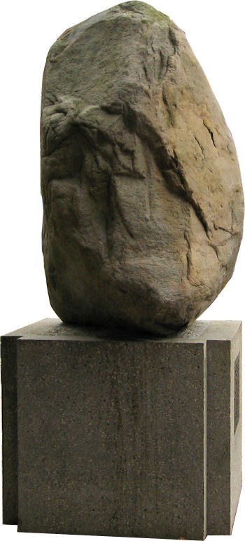
The 'Amersfoortse Kei' is a big boulder located in the centre of Amersfoort, from this the name 'Keistad' (Bouldercity) is formed and the inhabitants are called 'Keientrekkers' (Boulderpullers).

The noble man Everard Meyster placed a bet with some of his friends that he could convince the inhabitants of Amersfoort to move a large boulder from the 'Leusderheide' into the city. It is not known how he did that, but he managed it. So on June 7, 1661 in total 400 inhabitants of Amersfoort pulled the boulder to the centre of the city (Varkensmarkt). In the local cafe 'Dolle Jonker' they all received beer and a pretzel.

To remember this occurance a commemorative coin was minted and a poem called the 'Keyklucht' was written. In 1663 Everard Meyster moved to Utrecht were he build a home with some memories to the action taken in Amersfoort. The home was called 'De krakeling' (The Pretzel). In 1674 the inhabitants of Amersfoort saw that they had been stupid to pull the boulder from the Leusderheide for no reason and were ashamed of themselves. So the boulder was buried in the centre of the city (Varkensmarkt).

Later generations were not ashamed for this action and in 1903 the boulder was excavated from the 'Varkensmarkt' and in 1954 it was placed at its current location. In the 1970's the yearly 'Keistadfeesten' were started, and from several countries different boulders were introduced into Amersfoort. These boulders are still located in the public garden near the 'Stadsring'.

How to find the 'Amersfoortse Kei'?

Parking Places can be found at 'Koestraat' N52° 09.177 E005° 23.304, and 'St. Joris Plein' N52° 09.342 E005° 23.116.

Then you can walk to the coordinates and find the 'Amersfoortse Kei'. Go to N52° 09.165 E005° 23.205.

De Amersfoortse KeiThe earthcache

To be able to log this cache as found you will have to perform some tasks and answer some questions:

The 'Amersfoortse Kei' is placed on a socle. On the socle to plates are attached. Answer the following questions:

  • Take a picture of yourself or your team mates and your GPSr with the 'Amersfoortse Kei' in the background.
     

  • What is the weight of the boulder as of 08/NOV/1990?
     

  • From what type of stone is the 'Amersfoortse Kei' made of?
     

  • Make an estimation of the height of the 'Amersfoortse Kei'

Now walk along the public garden towards the following coordinates N52° 09.189 E005° 23.492.Along the way you will pass the boulders donated by several countries. All boulders originating from different types of stone/rock. Arrived at the next coordinate, answer the following question:

  • Describe the color of the stone located here, the stone/boulder clearly shows the signature of the Swedish king?
    or..
    Give me the information the stone/boulder is made of? The sign has returned.

To log this cache you will have to email me the answers to the questions (using my profile) and upload the picture with your log. Logs with wrong answers and/or without pictures will be deleted without notice.

GCRules


Additional Hints (No hints available.)