Once estimated to be in excess of 20,000 acres, today less than
4,000 acres remain of Nebraska’s eastern saline wetlands. These
wetlands form a regionally unique complex located in floodplain
swales and depressions within the Salt Creek, Little Salt Creek,
and Rock Creek drainages in Lancaster and southern Saunders
counties, Nebraska. The source of saline water to the wetlands is
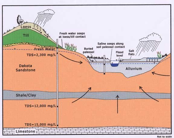
from groundwater deep in the underlying Dakota Formation.
The Dakota Formation is composed of Cretaceous-age sedimentary
rocks including sand, silt, and clay layers, containing sodium
salts deposited by an ancient sea that covered the state more than
100 million years ago. Water-level observations of the wetlands
indicate a strong upward hydraulic gradient between the Dakota and
the land surface. This steep gradient produces an upward flow that
causes saline groundwater deep within the Dakota to rise to the
surface across large parts of the wetland area. The groundwater has
been found to have salt concentrations as high as 15,000 milligrams
per liter. Seawater is about 35,000 milligrams per liter. Carbon-14
dating indicates that the groundwater is between 15,000 and 35,000
years old.
Saline wetlands led to the establishment of the city of Lincoln,
NE along Salt Creek because of the short-lived salt mining industry
they produced in the area during the 1860's. As the name of the
creek implies, the potential for commercial salt production from
saline wetlands played a key role in Lincoln's settlement and early
history. During the last century, the saline marshes suffered
extensive degradation through commercial and residential
development, road construction, and agriculture. Today, Nebraska's
eastern saline wetlands are considered to be among the most
restricted and imperiled ecosystems.
The listed coordinates will take you to the Lincoln Saline
Wetlands Nature Center. Parking is available. Visitors are required
to remain on the woodchip trail that runs through the wetland. The
area is open one hour prior to sunrise through one hour after
sunset. Enjoy a hike while you’re there and take note of the
abundant wildlife present, especially the variety of birds, and the
unique flora that grows in the saline waters.
In order to log your visit you must:
- Post a picture of yourself or your group by any landmark,
object, or scenic view in the nature center.
- Email the answers to the following questions to the cache
owner:
- What type of structure is located at the listed cache
coordinates?
- What type of structure is located at N 40° 49.708 W 096°
43.963?
- Which agency manages the Lincoln Saline Wetlands Nature
Center?
www.earthcache.org
EarthCache Masters
