
 There is little public parking in the area. There is one
small parking lot (0.5 hr limit; N33 44.385 W118 22.330) and a
larger paid parking lot west of the coordinates and walk next
to the road on the well worn path. The road is narrow as it
passes over the landslide, so there is no possibility of
stopping for a quick grab. Cycling is popular long this road
and may be the best way to access the coordinates.
There is little public parking in the area. There is one
small parking lot (0.5 hr limit; N33 44.385 W118 22.330) and a
larger paid parking lot west of the coordinates and walk next
to the road on the well worn path. The road is narrow as it
passes over the landslide, so there is no possibility of
stopping for a quick grab. Cycling is popular long this road
and may be the best way to access the coordinates.
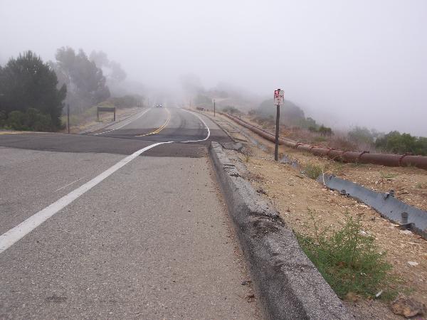
As you walk toward the coordinates from the parking area, Palos
Verdes Drive drops down a relatively short steep incline at (N33
44.373 W118 22.155). This marks the edge of the slide.
The Palos Verdes Peninsula is an elongated dome of layered
sedimentary rock above schist. Much of the layered rock is the
Monterey Formation, a marine rock composed of shale, dolostone,
siltstone and sandstone. Because of the dome structure, the layers
in the Monterey Formation dip toward the ocean all the way around
the peninsula.
The oldest portion of the Monterey Formation was deposited
during a time when volcanoes in the region were active. As a
result, there are some basalt intrusions and layers of tuff in this
section. One layer that is often found about 530 feet below the
surface is called the Portugese Tuff. The tuff in this layer has
been altered to bentonite, a clay material that has very little
cohesion when it gets wet.
While some prehistoric movement had occurred in this area, the
area had been extensively developed prior to 1956. Modern-day
movement began when the construction for the extension of Crenshaw
disturbed the upper portion, or head, of the slide. Irrigation from
the development also increased the available ground water in the
area, decreasing the strength of the Portuguese Tuff. Analysis of
the rock layers show that as little as a 6 degree slope will begin
to slide along the Portuguese Tuff.
Typically a slide will stop itself as the material at the
bottom, or toe, of the slide piles up on itself. On the Peninsula,
the toe of the slide is constantly eroded away by the ocean, so the
slide continues slipping into the ocean.
 The road at the coordinates is under
constant motion. Cracks form in the asphalt as the soil
underneath slide down hill and entire sections move at
different speeds. Periodically, the road is repaved and
straightened. Each time, the white line marking the right edge
of the road is painted straight. Over time this line becomes
offset. In the picture, the line in the foreground takes a jog
to the right as it crosses the newly paved section to match up
with the line in the back of the picture.
The road at the coordinates is under
constant motion. Cracks form in the asphalt as the soil
underneath slide down hill and entire sections move at
different speeds. Periodically, the road is repaved and
straightened. Each time, the white line marking the right edge
of the road is painted straight. Over time this line becomes
offset. In the picture, the line in the foreground takes a jog
to the right as it crosses the newly paved section to match up
with the line in the back of the picture.
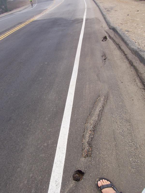 Also notice the pipes that parallel the road.
These are utilities that are typically underground. However,
due to the constant movement in this area, they have been put
above ground, presumably so they can be moved and repair
easier.
Also notice the pipes that parallel the road.
These are utilities that are typically underground. However,
due to the constant movement in this area, they have been put
above ground, presumably so they can be moved and repair
easier.
Some sections of the slide have been stabilized by dewatering
the soil, however, that technique has been unsuccessful in this
portion of the slide.
Prior to this slide, Los Angels County didn’t require geologic
evaluations prior to grading. As a result of the slide, new
ordinances were passed requiring an engineering geologist’s review
of grading.
Logging requirements:
Send me a note with :
- The text "GC15FGV Portuguese Bend Landslide" on the first
line
- The number of people in your group.
- Post in your log the offset of the white line (looking east
from the question coordinates to the earthcache coordinates)on the
road and the condition of the road. Look for cracks etc. At my
visit in Aug 2007, the offset was about 7 inches.
- Look at the last log and see if there was any movement between
each observation.
Technical:
The above discussion is much simplified. The source below along
with many others provides more detailed discussion of the geologic
history, lithology, structure, and movement of the slide. It also
includes information specific to the various portions of the
landslide complex.
The above information was compiled from the
following sources:
- Ehlig, Perry, Portuguese Bend Landslide
Complex, Southern California, in Geological Society of America
Centennial Field Guide – Cordileran Section, 1987.