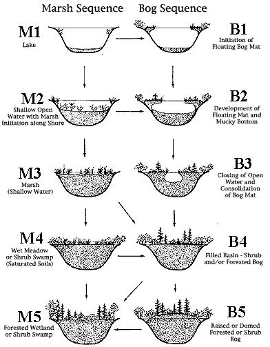
As the glacier retreated 10,000-13,000 years ago, huge chunks of ice were buried in sand and gravel. When the ice blocks melted, they left steep-sided basins in the glacial till, many of which filled with water to become kettle ponds. The sluggish, deep waters of some kettle ponds provide nutrient-deficient, acidic, anoxic (oxygen-deficient) conditions that few species other than Sphagnum mosses tolerate. A floating mat of Sphagnum on a framework of other plants take hold at the margins of these ponds. The mat expands both vertically and horizontally into the water as peat accumulates to create quaking Sphagnum bogs.
Bogs receive all or most of their water from precipitation rather than from runoff, groundwater or streams, and are encircled by higher ground which blocks the outward flow of water. Thus, whatever materials are washed into or deposited in a bog remain there permanently; dead plant materials build up to great depths. Because the filling of a bog pond is a very slow process, taking several thousand years depending upon the original depth of water, all stages of bog development may be encountered. In some bogs, a small pool may remain in the center of the bog. In others, the spreading mat has engulfed most of the open water and trees have invaded the floating mat. And in still other bogs, the forest may have closed in, hiding all outward traces of the former open bog. The end product in all cases is a mature forest generally dominated by trees adapted to water-logged, peaty soils.
In kettlehole bogs, the plant communities often form concentric rings around the pond. Vegetation patterns change from pond edge to upland edge based on environmental gradients of hydrology, topography, water chemistry, abundance of nutrients, and depth of the peat mat. Due to fluctuating water levels and nutrient regime, size and species composition of the plant communities can vary. As often as not, the plant assemblages grade into transition zones that may be barely distinguishable out in the bog.
What makes bogs so interesting is the fact the researchers can’t simply look at a bog and know exactly how it formed. The actual history of a bog lies well below surface in the layers of accumulated peat. Only, by studying a core sample, analyzing the past of the bog can a researcher know how the bog was developed. Studying stratigraphy can reveal the historical development of a bog and shifts in the distribution of plant species due to climatic. The bog is a window into climate change in the past.
Do not venture into the bog, as it is much deeper then it appears from the roads edge. Using the drawing below select the stage of either the marsh or bog that this kettlehole is in, and calculate or estimate the percent of the original pond that is now covered with vegetation. Then email me the answers through my profile. It also would be nice if you would post a photo so others would know what they have to look forward to at this earth cache.
For more scientific information go to Natural History of a Bog