Background
This is a very interesting and unique area. First, it is not to be
found on any map. Second, one needs to walk through the woods for
about .14 miles until the actual trail is reached, which after a
short .12 mile walk quickly opens up into a dark red landscape of
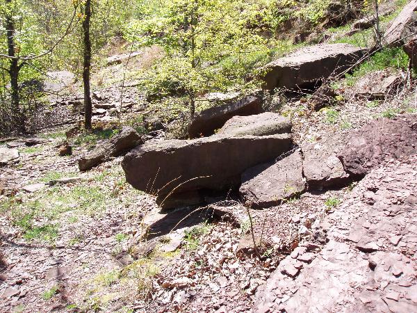
rock. The uniqueness of this area is characterized by flaggy, fresh
exposures of sedimentary red beds. Once you reach ground zero,
there are large fields of flagstone strewn everywhere. About 200
feet further, there is a bonus feature, a high wall of basalt,
which is an igneous rock intrusion feature.
The red beds are from the Early Jurassic Towaco Formation,
consisting of layered shale and intervening flaggy sandstone that
preserve a variety of very well-preserved sedimentary structures
and some cool features including ripple marks, desiccation cracks
and occasionally, if you are lucky, trace fossils (rare dinosaur
tracks which are very tiny). It is illegal to remove anything,
especially fossils, from the area. Please look and handle gently
but do not destroy. At ground zero, there are a few fantastic areas
where you can see the layers of the shale on some larger rock
samples. FYI: There is a considerable amount of 3/4" Red Shale
which goes for about $79.00/yard at your local landscaper
commercial supply store.…don’t get any ideas!
How is sedimentary rock
formed?
For thousands, even millions of years, little pieces of earth have
been eroded and worn away by wind and water. These little bits of
earth are washed downstream where they settle to the bottom of
rivers, lakes, and oceans. Layer after layer of eroded earth is
deposited on top of each, pressed down more and more through time,
until the bottom layers slowly turn into rock. Shale rock is a type
of sedimentary rock formed from clay that is compacted together by
pressure. They are used to make bricks and other material that is
fired in a kiln. The small amounts of sandstone you may encounter
are also sedimentary rocks made from small grains of the minerals
quartz and feldspar. They often form in layers as seen in this
picture. They are often used as building stones.
 To log this cache, you
must:
To log this cache, you
must:
1. With your log, submit a picture of you and your GPSr standing in
front of or next to an outcrop of red shale.
2. With your log, submit a picture of a piece of shale and a piece
of basalt in your palm.
3. In an e-mail, describe the differences you can observe between
the shale and the basalt.
4. In an e-mail, describe the direction of the layers you see of
the red shale. Why do you think they run in that direction?
.
.
 The following text will not be seen after you upload
your website, please keep it in order to retain your counter
functionality
The following text will not be seen after you upload
your website, please keep it in order to retain your counter
functionality
perfume
image counters