There is very interesting information right beside the parking lot at the posted coordinates.
Located in what is now Cheam Lake Wetlands Regional Park, this Earthcache highlights the interesting geological features in the area. At this Earthcache you are standing on the deposits of one of the largest landslides ever found in Canada, but thousands of years old. Look up at Mount Cheam and imagine that it used to be much bigger before collapsing into the area you are standing in. The limestone combined with organic matter (carbon) to become Marl.
Marl is common in post-glacial lake bed sediments, often found underlying peat bogs. In this case, the area was a glacial lake bed at one point.
Marls are calcium carbonate or lime-rich muds or mudstones which contain variable amounts of clays and calcite or aragonite. The term is most often used to describe lacustrine (lake) sediments but may also be used for marine deposits. Marl contains 35-65% clay and 65-35% carbonate, with other substances sometimes present. This soft, loose, earthy, material is mined for use as a soil conditioner and acid soil neutralizing agent. The term 'Marl' is most commonly used in English-language geology, but an equivalent term "seekreide" is used in Europe.
First explored for Merl deposits in the early 1900's, mining occurred until 1988. The mine was closed, and the park established in 1990. According to our research, this is the ONLY inland Merl deposit in the Fraser Valley Region.
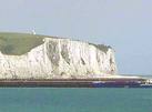
A famous example of Marl is the lower stratigraphic units of the chalk Cliffs of Dover, in England. The Cliffs of Dover consist of a sequence of glauconitic marl followed by rhythmically-banded limestone and marl layers. They look like this:
Today the old mine has become a 93 hectare Regional Park. It has returned to a nature paradise remarkably quickly.
The park is becoming a very popular bird watching spot, with over 200 (and counting) different bird species recorded. Other activities include hiking, picnics, wildlife spotting, nature appreciation and yes, environmentally sensitive geocaching. About ½ of the park is covered by the lake, with marsh and forest making up the balance.
Cheam Lake Wetlands are designed and managed to protect sensitive habitat and wildlife. There are over two kilometers of trails, a floating bridge, information kiosk, information shelter, toilets, seasonal running water, and six picnic tables.
The Park is located on the north side of Highway 1, about 15 Km east of Chilliwack. Heading east on Highway 1, leave Highway 1 at Exit 135 and proceed North on Highway 9. Turn right at the round-about and proceed to Elgey Road and turn left. Cheam Lake Wetlands is located at the end of Elgey Road. There are signs to follow too.
Earthcaches are designed to be educational virtual caches. To log this Earthcache you must:
1. Indicate in your log something new you learned on site. There are so many things to learn here, we will let you pick one or more. You might indicate some evidence of the former mine use you discovered, or comment on specific ways that nature is reclaiming the old mine. You might look at the info kiosk if you really get stuck for an answer!
2. Indicate how many in your group
3. Try to find some Marl onsite (no digging should be required - so just don't dig!) and post the coordinates or where you found it. . For an example, go to the posted coordinates, than go find your own example. There are quite a few locations to find some in the area. For ideas check the past logs - in the water, roots of a fallen tree near the trail to the south are good choices.
4. Please post a photo to show you visited the park. VIRTUAL VISITS DO NOT COUNT.
5. Posting photos is encouraged, but not required. The park is becoming very photogenic.
Failure to follow the logging requirements may result in log deletion. As the founder, we are required to maintain the integrity of logged visits. Thank-you for visiting the Cheam Lake Earthcache. We hope you enjoy learning more about the earth and history of the Cheam Wetlands Park.
Become an Earthcache Master too: www.earthcache.org