The Annapolis Royal Marsh was developed through a partnership between Ducks Unlimited and the town of Annapolis Royal. It is currently being used to treat the community's waste water before it enters the Annapolis River.
A constructed wetland is most often created to treat waste water created by humans. It acts as a biological filter, removing sediments and pollutants. The vegetation provides a substrate (roots, leaves and stems) upon which microorganisms that break down organic materials can grow. These microorganisms feed on the nutrients and pathogens in the waste water. They break down nitrogen compounds into less harmful forms which are then released into the atmosphere. As the effluent moves past the plants, more minerals, nitrogen and phosphorous are absorbed into the plants.
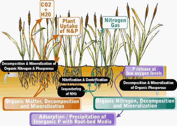
When the plants die and decay in the fall, carbon along with minerals and heavy metals are released and made available to the microbial community. The plants in a marsh are responsible for removing about 10% of pollutants. Microbial action and natural chemical processes are responsible for the remaining 90%
The 38-acre wetland conservation area is also an important breeding area for waterfowl and a host of other wildlife species, such as frogs, tree swallows, muskrats, and white-tailed deer that come to the water to drink. Gigantic great blue heron, tiny sandpipers, black duck, blue and green-winged teal, grebes, sora rails, red-winged blackbirds, song sparrows and yellow warblers have been spotted in this marsh.
The French Basin Trail is a 1.5 km walking trail the surrounds the Annapolis Royal Marsh. Informational plaques are located at various spots along the trail (these are taken down during the winter).
In order to claim this Earthcache, you must meet the following requirements:
1. Please post a picture of you and/or your GPS with the marsh and one of the informational plaques in the background. Also in your online post, please indicate which (if any) types of wild life you encountered
2. Please estimate the length and width of the marsh and e-mail your answer to me (DO NOT include this in your online post).
You DO NOT need to wait for confirmation from me before logging your find. All logs not meeting requirements will be deleted.
 Want to be further rewarded for visiting EarthCache sites around our planet? Then why not become involved in the exciting new EarthCache Masters program. Just visit three or more EarthCache sites (view guidelines) to start being sent special collectable EarthCache Masters pins. There are four levels to strive to own - Bronze, Silver, Gold and Platinum. Its free and easy to participate! Come join in the fun.
To visit an Earthcache near you, click on the Earthcache Listings, and find a site that interests you.
This geocache is part of the Gulf of Maine Council Geotour across Nova Scotia, New Brunswick, Maine, New Hampshire and Massachusetts. You can earn a limited edition geocoin for accumulating 100 points in the tour. Details for the geotour can be found at the GOMC website. To play, download the full geotour passport.