LE HARAS de JARDY
Ce multi cache vous propose une ballade (deux à trois kilomètres) de découverte du Haras de Jardy.
Attention, le parc de Jardy est ouvert de 8h à 19h30 (automne, hiver) ou de 7h à 21h (printemps, été) (plus tard certains jours, voir le panneau en entrant).
Vous aurez à traverser ce parc très agréable, tout en admirant les chevaux, pour y rechercher certains indices, mais d'autres waypoints ainsi que la cache sont situés en dehors.
Un peu d'histoire: ce fut tout d'abord un prieuré créé par les moines au XIIème siècle, qui devint petit à petit domaine agricole.
En 1890, Edmond Blanc dont le nom est lié à l'histoire des courses achéte la propriété pour y établir un haras qui sera pendant longtemps le plus réputé élevage de pur-sang d'Europe.
Vers 1950, l'écurie est rachetée par Marcel Broussac (grand industriel du textile) et devint la plus celèbre du monde.
Depuis 1980, l'état est propriétaire du domaine, et le Haras est maintenant le premier centre équestre de France. Pour compléter le tout, Golf et Tennis s'y developpèrent, ainsi qu'un important Poney club.
The "HARAS de JARDY"
This multi-cache proposes you a ballade (of two to three kilometers) to discover the Stud farm of Jardy.
Be careful , the park of Jardy is open from 8h to 19h30 (autumn, winter) or from 7h to 21h (spring, summer) (sometimes later, see the sign while entering).
You will have to cross this very pleasant park, while admiring horses, and seek signs, but some waypoints as well as the Cache are located outwards.
Some history:
It was first a priory creates by monks in XIIème century, which gradually became agricultural field. In 1890, Edmond Blanc whose name is related to the history of horse races, buys the property to establish there a stud farm which will be the most famous thoroughbred horse breeding in Europe for a long time. In about 1950, the stable is bought by Marcel Broussac (great textile manufacturer) and became the most famous in the world. The state has been the owner for 1980, and the stud farm is now the first riding school of France. G
olf, Tennis developed there, as well as an important Poney club.
>>>>> FRANCAIS
Le site est situé en forêt de "Fausses reposes", espace de chasse à courre royale dès Henri IV qui chassait le cerf (d'ou son nom, faisant penser à la bête traquée qui tentait de se cacher pour se reposer un peu).
Vous pouvez vous garer au parking indiqué.
WP1 (Une des entrées du parc du Haras de Jardy)
Ce sont les premières coordonnées.
Entrez dans le parc et dirigez vous vers WP2.
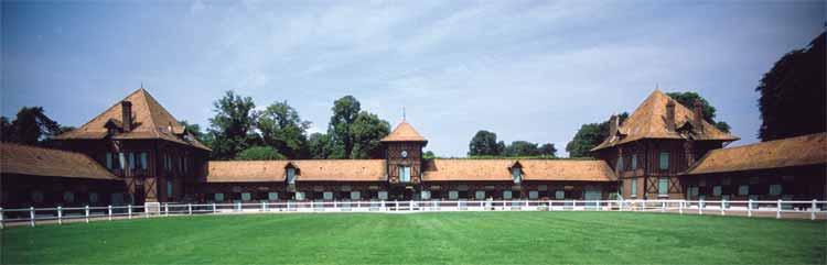
WP2 (Pavillon de la Marche)
N 48° 49.768 E 002° 09.533
Admirez déjà cette jolie écurie, proche du Golf.
Combien y-a-t-il de stalles à chevaux (si vous ne voyez pas bien l'autre partie, l'écurie est symétrique). Soit A ce nombre.
WP3
N 48° 49.(A/2)(A-10)(A-5) E 002° 09.(A-8)(A-7)(A-6)
(Attention, ne pas multiplier les parenthèses).
Cherchez devant vous:
B le nombre d'éléments nécessaires à la construction du banc (non seulement les pièces horizontales).
C le nombre d'abris à chevaux assez proches (>1).
WP4 (Grande écurie)
N 48° 49.5BB E 002° 09.(C-1)44
(Attention, ne pas multiplier).
Admirez les chevaux, et trouvez le nombre D de têtes métalliques vertes.
Calculez pour le WP5:
X1X2X3 = 400 + (20*D) +4 (* is multiply)
Y1Y2Y3 = 400 + (90*D) +1
Sortie du parc du Haras
Pour continuer votre aventure Geocaching, il vous faudra maintenant ressortir du parc.
Mais si vous n'êtes pas pressé, n'hésitez pas à vous promenez un peu vers les autres écuries et terrains d'entrainement (manèges, dressage, sauts d'obstacles, présentation de chevaux à certaines dates...).
Evitez le bout du parking où à priori la sortie est fermée. Et, plutôt que de revenir en arrière, vous pouvez sortir du parc en suivant dans l'ordre les trois Waypoint suivant:
N48 49.512 E2 09.094
N48 49.439 E2 09.072 (une barrière protège de la route D182 très fréquentée)
N48 49.390 E2 09.161
WP5 (Borne)
N 48° 49.X1X2X3 E 002° 09.Y1Y2Y3
Vous devez vous trouver près d'une toute petite mare (elle sera peut-être à sec en plein été). Trouvez une borne en ciment.
Relevez E les deux derniers chiffresdu numéro de téléphone.
Ainsi que F les deux derniers chiffres du N° commencant par 611... de cette borne.
WPF (La cache)
N 48° 49.4 ( E/6) (7) E 002° 09.5 ( (F/2) -12 ) )
(Attention, ne pas multiplier).Et maintenant, réjouissez vous de votre découverte...
 >>>>> ENGLISH
The site is located in forest of “Fausses reposes”, understand in English "False rest". It was a large space for royal stag hunting since Henri IV, the name making think to the tracked animal which tried to hide and rest a little.
You can park yourselves at the indicated place.
WP1 (One of the entries of Jardy park)
It is the first indicated coordinates . Enter the park and go then to WP2.
WP2 ("Pavillon de la Marche")
N 48° 49.768 E 002° 09.533
Admire this pretty stable, near the Golf. How many stalls for horses ?. If you can't see the entire frontage, know that the barn is symmetric. A will be this number.
WP3
N 48° 49.(A/2)(A-10)(A-5) E 002° 09.(A-8)(A-7)(A-6)
(Be careful, don't multiply brackets).
Seek in front of you:
B the number of pieces of the bench (not only the horizontal ones).
C the number of shelters for horses you can see nearby (>1)
WP4 (Great stable)
N 48° 49.5BB E 002° 09.(C-1)44
(Be careful, don't multiply).
Admire horses, and find the number D of metal green heads.
Calculate for WP5:
X1X2X3 = 400 + (20*D) +4 (* is multiply)
Y1Y2Y3 = 400 + (90*D) +1
Very important: Jardy Park exit
To continue your Geocaching adventure, it will now be necessary for you to get out of the park. But if you have some time, don't hesitate to walk a little towards the other stables and grounds (riding school, horse training, jumps of obstacles, horse show on certain dates…). Avoid the bottom of the carpark because this exit is often closed. And, rather than retracing one's steps, you can leave the park following the three following Waypoints, in this order:
N48 49.512 E2 09.094
N48 49.439 E2 09.072 (a barrier protect you from the main D182 road )
N48 49.390 E2 09.161
WP5 (Phone number)
N 48° 49.X1X2X3 E 002° 09.Y1Y2Y3
You must be close to a very small pond (it will be perhaps dry in summer). Near the trail, find a square concrete block.
E will bethe last two digits of the telephone number.
F will be the last two digits of the number beginning by 611...
WPF (La cache)
N 48° 49.4 ( E/6) (7) E 002° 09.5 ( (F/2) -12 ) )
(Be careful, don't multiply). And now, enjoy your discovery