Kincaid Park's Eolian Landscape - Cliff Head Dune EarthCache
Kincaid Park's Eolian Landscape - Cliff Head Dune
-
Difficulty:
-

-
Terrain:
-

Size:  (not chosen)
Please note Use of geocaching.com services is subject to the terms and conditions
in our disclaimer.
Eolian processes are the eroding/transporting/depositing
functions used by the winds to shape the surface of the Earth and
other planets. This site demonstrates the impact of erosion,
transportation and deposition of soils caused by the wind.
This is an EarthCache -
without container or logbook - where you'll observe, document
through measurements and photographs, and report your findings via
email to earn credit for this cache. Logs which do not conform to
these requirements will be deleted, as this cache requires a
demonstrated acquisition of knowledge about the geologic forces at
work in this section of Kincaid Park. Read all the
requirements for completing this cache before you visit the park,
and equip yourself with the necessary tools (including a
camera).
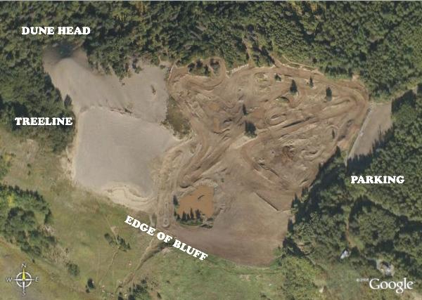
This aerial photograph shows Kincaid's Motocross Park, located off
Jodhpur Rd beyond the west end of Dimond Blvd. During its earliest
years of use by homesteaders and construction companies this pit
proved to be an excellent source of relatively clean sand and was
mined extensively. Today the pit's vegetation-free surface is the
only place inside the city where riders can use their snowmobiles,
four-wheelers and dirt bikes, with organized racing held in the
summer months. The extensive motorized activity in the pit coupled
with the lack of vegetation has contributed directly to the
creation of a moving coastal Cliff Head Dune.
Your parking area is at right, on the east side of the complex.
From your vehicle you can see the large dune rising to the west
beyond the motocross track. Walk downhill on the gated road leading
south down towards the bluff and the complex below. Move westwards
towards the dune itself, looking for the chainlink fence bordering
the actual track area's south side. Are there clues to erosive wind
activity at the base of this fence? Measure the height from the top
of the fencepost's concrete anchor to the ground below at its
largest separation (thanks to the wind, winter snows probably won't
hamper your view). This distance shows that soil mass has been
eroded from the loosened sand through a process called
deflation, where loose fine-grained particles are removed by
the wind. Scouring of surfaces by the wind may produce areas known
as blowouts, where soils are disturbed or less-compacted and
are thus more susceptible to wind transport. Blowouts are common in
areas where human activity has occurred across exposed non-bedrock
soil surfaces without any subsequent stabilization of soils.
Continue westward up and across the dune's slope, walking towards
the treeline to the left of the head of the dune. If you've arrived
on a windy day you'll witness first-hand the wind transporting
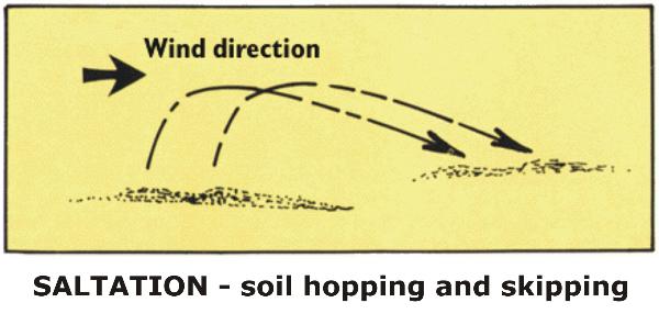
particles up the dune through suspension, saltation and
creep. Small particles under 0.2 millimeters in diameter are
held aloft in a process known as suspension, where they can
be borne aloft indefinitely. Winds blowing across the braided
areas, mud flats and sand bars on glacier-fed rivers can pick up
enough material to create dust storms - a familiar occurrence on
the Knik River near Palmer AK. Saltation lifts sand-sized
particles no more a centimeter above the ground in a series of
short hops or skips downwind. During saltation the particles bump
and push larger grains along the surface in a process known as
creep, which can account for as much as 25% of grain
movement across exposed surfaces.
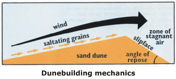
Deposition - the accumulation of wind-borne sediments into
mounds or ridges - provides clues about wind direction, consistency
and speed. Dunes are built up through the process of deposition as
materials move up the gentle upwind slope. When particles at the
crest of the dune exceed the angle of repose (steepest angle
at which materials will remain cohesive), they spill over in a tiny
landslide or avalanche that reforms the slipface - the steep
upwind side of the dune lying perpendicular to the wind's
direction. As the avalanching continues, the dune moves in the
direction of the wind. Coastal cliff head dunes (such as this one)
are formed where materials loosened by wind and wave action are
lifted onto the face of the shoreline bluff and deposited in
growing mounds of material. The cliff head dune may be very mobile
or stabilized by obstacles such as vegetation or sand fences. When
winds blow consistently from one direction the dune will be simple
in shape with slipfaces uniformly perpendicular to the wind.
As you climb the dune, move west off the edge and view the head
(crest) of the dune from its southwest side at the treeline.
Looking to the east-southeast you'll see across the Anchorage
Coastal Refuge and right down the mouth of Turnagain Arm. At low
tide extensive silt flats (more than 900 feet deep in places to
bedrock below) are exposed to the Eolian processes of the wind. As
the glacier-fed rivers at the head of Turnagain Arm continue to
deposit silt onto the flats, the wind continues its work of
reshaping those flats at low tide. Much of the upper soils of
Kincaid Park consist of fine particles lifted from the flats and
deposited on the glacial till gravel outwash sub-base of the
bluff.
To demonstrate your acquisition of knowledge about the Eolian
forces at work in this section of Kincaid Park, please answer these
questions briefly in an email to me through the geocaching.com
website. Post a photo in your log of yourself at the dune (not
necessarily the top of the dune) with the crest visible in the
photo and/or at the chain link fence deflation site, but don't
post your answers in your log. Photo is not required - but it helps
record your passage across this landscape! Report in the online log
how many were in your party during your visit. Logs not conforming to these requirements will be
deleted.
1) Based on your observations, what is the depth of soil that has
apparently deflated from under the chain link fence?
2) Observe the exposed dune's crest and report:
A) its direction of travel (using directions such as east or
SE)
B) your estimate of its height above the parking area
C) the prevailing direction of the wind at this location
3) What bio-community is the dune impacting with its travel, and
how?
4) Why is this particular portion of the southern cliff head dune
system here at Kincaid Park moving, while the rest of the cliff
head dunes to the west are relatively stable?
The above information was compiled from
the following sources:
A.S. Walker, "Deserts: Geology and Resources" (online edition), US
Geological Survey, 1998 USGS Geologic Information General Interest
publications, http://pubs.usgs.gov/gip/deserts/contents/
L.M. Dilley & T. Dilley, "Guidebook to Geology of Anchorage,
Alaska", 2000 (1st edition) Anchorage, AK
Cache placed by permission of the Municipality of Anchorage's
Kincaid Park.
The
Geological Society of America (GSA) EarthCache Project - Learn
about the EarthCache Master Program:
earn Bronze / Silver / Gold / Platinum status, with an EarthCache
Master Pin awarded at each level!
Additional Hints
(No hints available.)