Sackville Waterfowl Park EarthCache
-
Difficulty:
-

-
Terrain:
-

Size:  (not chosen)
Please note Use of geocaching.com services is subject to the terms and conditions
in our disclaimer.
The Sackville Waterfowl Park, contains a 19 hectare shallow
freshwater wetland created by reflooding a saltwater marsh that was
drained three centuries ago. Its primary purpose is to provide
wetland habitat.
The Sackville Waterfowl Park was established in 1988 as a joint
venture of the Town of Sackville and Ducks Unlimited Canada.
Located in the heart of Sackville, the Park is a truly beautiful
sight to behold. Originally, the park site was part of a vast
saltmarsh, flooded daily by the Fundy tides. To the native Mi'kmaq
people, the marshes were a valuable resource and waterfowl were
abundant. Cattail roots were a nutritious source of food and
grasses were used for basket-weaving. Acadian settlers came to the
area in the late 1600s. They began ditching and draining the
marshes to claim the rich soil for farming, an activity that
continues to the present day.
There are over three kilometers of trails, boardwalks, and viewing
platforms, as well as interpretive signage, in the Park that
provide the opportunity to view the approximately 160 species of
birds, waterfowl and over 175 species of plants that live in the
Park.
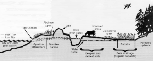
DYKELANDS ARE PREDOMINANTLY agricultural lands developed
from rich salt marshes found mainly in the upper Bay of Fundy of
Nova Scotia and New Brunswick. Occuring in areas of high tital
range, dykelands awe their existence to dykes constructed to keep
out the sea. Prior to dyking, extensive salt marshes occurred at
the mouths of tital rivers and in other low-lying coastal areas.
Saltmarsh plants helped to trap nutrient-rich sediments from the
tital waters on vast level areas which were ideal for development
of agricultural lands.
A Short History<
THE ACADIANS WERE DRAWN TO THE rich marshes of the Bay of
Fundy over 300 years ago abd designed and constructed many of the
present-day dyke systems. They understood the high agricultural
value of the marshes compared to the less fertile, forested
uplands.
The dykeland farms of the Acadian settlers provided for their
needs as well as giving a surplus for export throughout the eastern
seaboard. After the Acadians were expelled by the British in 1755,
they were replaced by the New Englands Planters, Yorkshire farmers,
and the United Empire Loyalists. Each new group of settlers claimed
new ares of salt marshes, which the used primarily for pasture and
hay production.
In 1949, the Maritime Marshlands Rehabilitation Act was introduced
by the Canadian governement to prevent the loss of additional
dykeland. From 1949 to 1970, over 30,000 hectares of dykeland were
secured.
Dykelands As Wildlife Habitat
ALTHOUGH THEIR PRIMARY USE IS for agriculture production,
dykelands and surrounding areas can be exeedingly important for
wildlife. Dykelands are used by many species for short periods or
year-round. Hay meadows and vegetated drainage sitches on dykelands
provide habitat for a community of marsh and grassland animals.
These range from Meadow Voles and Shrews, Marsh Hawks and Kestrels,
to deer, red foxes, and coyotes. Dykelands may also provide
roosting sites for migrating shorebirds at high tide.
The diversity of habitats in the vicinity of dykelands, including
salt marshes, freshwater marshes, and tital flats, as important in
maintaining a wide range of species and complex biological
interactions. This diversity in a localized area ensures that the
loving requirements of numerous species are met. In addition, Fundy
dykelands are located on the traditional migration routes of a wide
range of bird species.
Idle dykelands have long been recognized for their potential as
habitat for waterfowl and other wildlife. Since the mid-1960s,
Fundy dykelands have been used for the creation of artificial
wetland impoundments, thereby enhancing populations of waterfowl
and other wetland wildlife. Dykeland soils, consisting primarily of
marine wilts with a high nutrient content and capacity for
retraining water, are ideal for creating freshwater impoundments.
In many areas, abandoned dykeland has been acquired by government
and private conservation organizations such as Ducks Unlimited
Canada for wetland creation and management.
To log: 1) Picture at structure near coordinates with gps in hand
(its a small covered bridge in the centre of the park)
2) Measure approximate salinity of water by 1) using a hydrometer
OR 2) evaporating approx 1 litre of water from the marsh and
comparing amount of salt compared to tapwater. Email me your
findings. DO NOT POST YOUR FINDINGS IN YOUR LOGS. You can log
the find after you receive approval from the cache
owner.
Additional Hints
(No hints available.)