![Member of Middle Tennessee GeoCachers Club [www.mtgc.org]](https://imgproxy.geocaching.com/3e4f8ad26cd3b430ca7261e8e4b4d4576787e216?url=http%3A%2F%2Fwww.mtgc.org%2Fmtgc_member-banner.gif)
This Cacher Served Honorably in the
United States Army and is a Proud Member of the MAGC:

On Hwy 149 in Houston County near the Stewart County Line. You are
standing inside a meteorite impact crater.
This is an EarthCache. An Earthcache is an educational form of a
virtual cache. The reward for these caches is learning more about
the planet on which we live - its landscapes, its geology or the
minerals and fossils that are found there. Earthcaches are
developed in association with the Geological Society of
America.
Click Here For Earthcache
Information
Between 100 and 200 million years ago, a large meteorite struck
earth around present-day Cumberland City in Central Tennessee. A
meteor near 1000 feet in diameter, weighing in excess of 100
million tons and traveling at 10 miles per second (36,000 mph)
struck the earth at this location with a shattering impact.
Scientists believe it penetrated to a depth of around 2000 feet
below the surface and exploded with the force of a 1000-megaton
bomb. Shock waves raced in all directions,( Producing Shatter
Cones, see source below), and a fiery, mushroom cloud of fine rock
dust and debris rose high in the air.
The impact created a crater some 14.0-km (7.0-miles) in diameter,
and one-half mile in depth. Scientist believed the earth's surface
appeared to be damaged forever. Millions of years passed and
erosion and vegetation softened this ugly scar left by the
impact.
The rim of shattered rock disappeared, and the level of adjoining
land was lowered hundreds of feet by erosion. Since its discovery,
geologists have studied this phenomenon. This crater is now known
as the Wells Creek Basin.
TENNESSEE METEOR CRATERS There are three meteor craters located in
Tennessee. The 3 mile Flynn Creek Structure is northwest of
Cookeville, TN. It is rather distorted due to mountain building in
East Tennessee. The Howell Structure is nearly circular about one
mile in diameter and is located in Middle Tennessee north of
Fayetteville at Howell. The biggest and best is located west of
Clarksville at Cumberland City. An elliptical formation about 10
miles in diameter. It is know as the Wells Creek Basin. Wells Creek
and the Cumberland River join at the north wall of the crater.
These structures are remnants of the original as nearly a 1000 ft
of material may have been eroded away over 200,000,000 year period.
Therefore the original craters were larger and the actual age of
each is hard to fix.
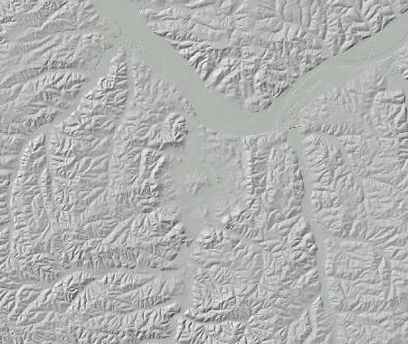
As Seen From Space
To claim credit for this cache, you
must post a picture of you or your group with your GPSr shown
standing at The Wells Creek Basin, Tennessee Historical Marker. The
marker title and number must clearly be visible. Logs without
photos will be deleted. Additionally, email me through my profile
on Geocaching.com the answers to the following questions:
1. When was the meteorite site discovered?
2. What were the circumstances of the discovery?
Geology on a Digital elevation model. View from south to north.
Geology of central uplift is: Orange peak, yellow and dark pink
areas at center are Lower to middle Ordovician Limestone. This
material was thrust upwards a distance as much as 800m+/-. Light
Pink through to orange are Silurian, Devonian and Mississippian
strata. Middle Ordovician Strata and above are flanking a ring
structure (seen as a topographinc high).
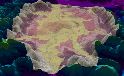
Digital Elevation
Model
From These Sources, Learn More
About:
Meteorite Impact Craters
Earth
Impact Database , Tennessee
Meteor Craters ,
American Musemum of Natural History ,
Terrestrial Impact Crater list , Tennessee
Landforms , Nature Notes ,
National Science Foundation
and Shatter Cones
Wells
Creek Shatter Cones, University
of Tennessee