Toponaut: Fountainhead
Inside this cache, you you will find a clue needed to search for Toponaut: Fountainhead 2, Stony Summit.
This series needs to be done in sequence, both geographically, in order of difficulty, and to retrieve clues to continue. Detailed instructions will be included for the first cache, and then decrementally so as the series progresses. All together the series will lead to a 5-6 mile round trip hike (or possibly more of course!).
Quick background: I went on an orienteering course with caching pal Englaand. Once. At night. We had a ball running for miles through the woods (orienteering is timed) following the map and finding waypoints. The map and legend are borrowed from orienteering, but there the similarity ends; there is no "real" compass use. And this park is closed at night. However, feel free to run!
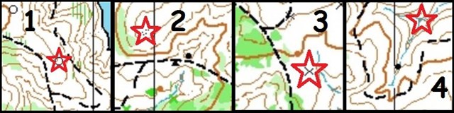
Quick aside: Also see a similar "Toponaut" series in Hemlock Overlook: Toponaut: Hemlock
You will need:
- A color printout of the topo map and the legend (both are found in the Gallery). Each cache page has a zoomed-in portion of the big map. You don't need to bring the zoomed-in ones, just the big one from the Gallery.
- A compass (your GPS compass will suffice if you trust it).
- The knowledge of how to project a waypoint using your GPS device.
- If you are unsure of how to proceed, there is a primer below.
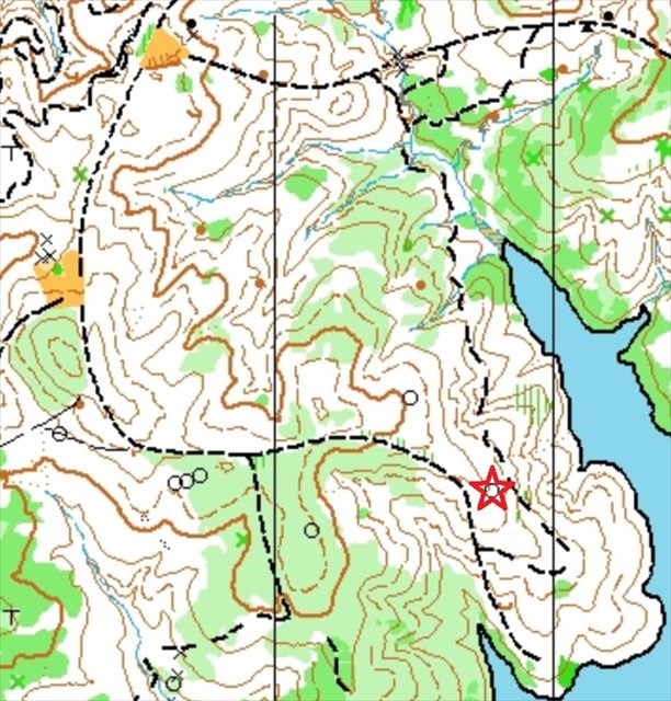
Navigate to the red star. Project 496 feet bearing 141 degrees to locate the cache.
Primer (intended directions with map reading tips along the way)
- Park at the posted coordinates for the cache. Head east on the blue equestrian trail to the junction of trails (listed as an additional waypoint). Then head south down the dirt road (dashed black line) until you make it to the section of the map shown above (this "target" map is a magnified portion of the large topo map just for this cache; you will need the full-sized map for the entire series.)
- You will pass by three large clearings (shaded orange areas) before the trail turns to the east.
- Soon after the trail turns mostly due east, look to the south of the trail for a grouping of three large piles of rocks (open black circles).
- The forest in which these rock piles reside is slightly more dense than on the north side of the trail. This is denoted by areas of light green. Darker green means a tougher bushwhack. No green means open woods.
- For an assist in finding the target location, mark the middle pile of rocks as a waypoint. The target location (the pile of rocks with the red star) is between 0.15 - 0.20 miles away.
- Continue east and slightly downhill (brown contour lines denote elevation; contour interval is 5 meters) on the trail.
- Use your compass to discern when the trail turns south, at which point you will need to leave the trail to the east to find the pile of rocks.
- While on the trail going south, if you come to an intersection, you've gone too far. While bushwhacking to the east, if you encounter another trail, similarly you've gone too far. Keep this trick in mind as you progress through the series; look ahead and find features that tell you that you have missed a target.
- Once you find the rock pile (which is visible from the trail), stand on it and perform the projection from there.
- Just to be clear: there is nothing hidden at the red star location. That is just where you do your projection from.
- Note: if you get lost, return to a known point and try again. Another tip is to use your compass to determine the direction of a trail or other feature to help determine where you are.
- As you use your GPS to navigate to the cache, pay attention to where you are on the map! This will be helpful/crucial in continuing to the next cache in the series.
Some other notes:
- I have set the "not winter friendly" attribute solely due to difficulties with finding the piles of rocks in the snow. I set the distance attribute to ">10km" (~6.2 miles), however with spot-on navigating it will be less than that.
- As you navigate, it might be prudent to come up with a point that is "too far". For example in the first cache, using the trail system as a guide.
- Within the cache you will find a distance and bearing needed for the next cache in the series. Record this but don't take it with you.
- Have fun exploring! However this is mostly ungroomed territory so be mindful of snakes, ticks, and other scary creatures.
Links to caches:
 No night caching


Best Series 2016