Tiger Mountain Blackout Mystery Cache
-
Difficulty:
-

-
Terrain:
-

Size:  (regular)
Please note Use of geocaching.com services is subject to the terms and conditions
in our disclaimer.
Tiger Mountain Blackout
Welcome to the Tiger Mountain Blackout Challenge cache!
This cache is another of the now familiar blackout caches located around the Seattle area for which, in order to complete the challenge and find the cache, you must first find all the other active caches within a given area.
About Tiger Mountain
Tiger Mountain is one in a group of six foothill mountains within the Issaquah Alps. It is located about in the middle of the group and is the largest and tallest of the Alps. The west side is very popular and heavily used while the east, south and interior areas are much less visited.
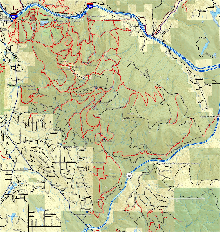
Tiger Mountain State Forest Map

Overview
In order to complete this challenge you must, for at a least one single point in time, have found or owned all the indicated active caches in the given area as determined by the posted coordinates and other given criteria.
This blackout has two versions to it, the hikers version and the geopolitical version. The differences are explained below.
Tiger Mountain Blackout Hikers Version
This version is actually a subset of the geopolitical version both in physical area and the types of required caches. When I originally conceived this cache it was planned for hikers since all the other blackouts are focused on the city cacher. The hiker type of cacher often is primarily interested in the purest aspects of the original game; simply going to and finding a cache located at the posted coordinates. The other side of that coin is that this type of cacher often wants little to do with urban caches, therefore the area is defined by terrain, or puzzle caches, therefore the cache type excludes those. Also excluded are challenge caches which first require the of finding additional caches outside the physical boundary in order to find and log the cache that is inside the boundary. At the time of publishing a total of 96 caches fit these criteria. A full list is provided below for clarity.
Tiger Mountain Blackout Geopolitical Version
After some more consideration and discussion with fellow city-hiker hybrid cachers, I expanded the boundary to the geopolitical and related features. This will also allow a nice tie-in with some other related caches that I will be placing in the near future. This version includes all puzzle caches and challenges caches with one exception; the Ancient Caches of King County will not be included due to its extreme difficulty. At the time of publishing a total of 127 caches fit these criteria.
Finishers Lists
Both the hikers and geopolitical versions will have their separate list of finishers, though if you finish the geopolitical without first finding the hikers, your name will be added to the hikers list as well since by default the hikers version has been completed.
Note Regarding Difficult Hides And Puzzles
There are a number of very difficult caches and it’s not reasonable to expect everyone to be able to find and solve them all completely independently. Asking for help and hints or nudges is absolutely fine and even expected but do try to stick to the general intent of the game. For example, make a few attempts at the cache before asking for a location hint and spend a couple hours on the puzzle before asking for help. When you do ask for help try a hint or nudge rather than the full solution or location. There aren't any hint police, but let's all give it our best shot.
FTF
Regarding first to find (FTF): In my opinion, there is the possibility of two FTFs on this cache. If the first to sign the log completed the hikers version, then there will be two FTFs, one for the hikers version and another one later for the first to compete the geopolitical version. If the geopolitical version is completed first then by default the hikers version is also completed and therefore there would be only one FTF. If the same person first completes the hikers version and then later the geopolitical version, than there is only one FTF.
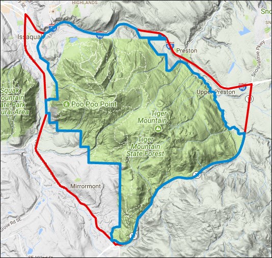
Boundaries Map

Details
Tiger Mountain Blackout Hikers Version
This trail focused blackout area is generally defined by the area known to hikers as Tiger Mountain and is shown by the blue colored boundary line in the map above. The major defining factor is elevation above the surrounding flatlands which is then modified to coincide with natural or manmade features, specifically waterways, roads and private property
Boundary
The boundary includes (clockwise):
North: The center of I90, the DOT Trailhead and the forest boundaries
East: The forest boundaries and the center of the Raging River and State Route 18
South: The center of State Route 18 and the forest boundaries
West: The forest boundaries, Chirico Trailhead and the 200 feet elevation contour line
Maps and Files
These boundaries are also shown in the map above which is clickable to take you to an interactive Google terrain map. The map will help clarify the boundary but unfortunately will not identify any caches since it is not possible to have the boundary and current geocaches shown on the same Google map at the same time. The good news is that you can fairly easily determine the included caches using the map and files below with many software options.*
View caches directly using Groundspeak’s map tool
GSAK users can poly filter using these Hikers Version polygon coordinates
MapSource and Basecamp can use this Hikers Version gpx file
Google Earth users can use this Hikers Version kml file
Google Earth users can also use a geocache overly: Getting Started with Google Earth
Caches
Questions will naturally come up for caches near the boundary or for other reasons so I’ve listed some of them below. Email me with questions you have about any others.
Included:
+ All active traditional and multi-caches
GC24K9Y DOT Trailhead
GCHBYR On the Way #4: Tigers near I-90
+ All active mystery caches based on coordinates found in a traditional cache
(similar to waypoints of a multicache):
GC13FPD Tiger Mountain Trail - Midpoint
GC13FPB Tiger Mountain Trail - Completion
+ Active challenge caches as noted below:
GC2QZYP Tiger Mountain Blackout
Not Included:
GCJC9R Hikers Hat Trick # 1 - On the Way to Poo Poo Point
GC2N926 Billy Rhynalds Maintenance Tech II Radio 1562
- Puzzle caches
- Challenge caches with prerequisite caches not completely within boundary
or based on puzzle caches, or requiring work to solve for the coordinates
GC231XZ Ancient Caches of King County
- A Challenge Cache
GC1A9AB Sam's Solar System: Bonus
GCRRDJ A Mugsy Hike
- Temporary caches: CITOs and Events
- Disabled Caches
Tiger Mountain Blackout Geopolitical Version
This larger blackout area is generally the geopolitical boundary of Tiger Mountain which is then modified to coincide with natural or manmade features, specifically waterways and roads. It is shown by the red colored boundary line in the map above
The boundaries are (clockwise):
North: The center of I90
East: The center of State Route 18
South: The center of State Route 18 and Issaquah-Hobart Road Southeast
West: The center of Issaquah-Hobart Road Southeast, Front Street South and Front Street North
Maps and Files
These boundaries are also shown in the map above which is clickable to take you to an interactive Google terrain map. The map will help clarify the boundary but unfortunately will not identify any caches since it is not possible to have the boundary and current geocaches shown on the same Google map at the same time. The good news is that you can fairly easily determine the included caches using the map and files below with many software options.*
View caches directly using Groundspeak’s map tool
GSAK users can poly filter using these Geopolitical Version polygon coordinates
MapSource and Basecamp can use this Geopolitical Version gpx file
Google Earth users can use this Geopolitical Version kml file
Google Earth users can also use a geocache overly: Getting Started with Google Earth
Caches
Questions will naturally come up for caches near the boundary or for other reasons so I’ve listed some of them below. Email me with questions you have about any others.
Included:
+ All active permanent caches except as listed under Not Included
GC2CKHP Issaquah Photo Mystery Tour
GCP01P Over The Top III - Under/Over
Not Included:
GC231XZ Ancient Caches of King County - A Challenge Cache
GC6YN2Z Mariners Legends #3: Edgar Martinez
GCMN1V Symbolism
- Temporary caches: CITOs and Events
- Disabled Caches
Logging Requirements
Once you have found all the required caches then you are free to go find the final; no need to check with me first. However, at the time of posting of your found log you need to show that you completed the challenge by using one of the four methods below. Anyone failing to do so will be subject to having their found log deleted without notice.
Bookmark List Method
Create a bookmark list called "[your name]’s Cougar Mountain Blackout." Make the bookmark list public and include this cache on it so that it shows up in the bookmark lists shown on this cache page. Add to the list all the caches you have found within the boundaries
My Finds Pocket Query Method
Forward by email your complete My Finds Pocket Query as downloaded from the geocaching website. My email address is shaddow.geo at gmail.com
GSAK GPX Method
Forward by email a gpx file created by GSAK with a poly filter using either the hikers version or the geopolitical version coordinates provided in the related section. My email address is shaddow.geo at gmail.com
Log List Method
Post a log to the cache page listing the date you found each cache, the cache code and the cache name. Post one cache per line and start each line with a line number. Use a single space between each item. You can order the list in any way that you want but maintain the given structure as it is very important to make it much easier to import into a spreadsheet. Please post the list only once after completing the challenges. Do not post as you go as each log would generate an email that will spam and irritate myself and the watchers. The list should look very similar to this:
001 5/4/11 GCXXX1 The First Cache In My List
002 6/1/11 GCXXX5 The Second Cache In My List
003 7/2/11 GCXXXB Another Cache Found By Me
…
203 8/17/12 GCXXXY The Second To Last Cache In My List
204 8/22/12 GCXXXZ The Last Cache In My List
The Cache
This cache is located at the posted coordinates but to post a find log you must first complete the challenge as noted in the description. Any found logs that are posted that don’t meet the criteria will be deleted without notice.
The cache is a lock-n-lock not at ground level and covered with natural camouflaged. I’ve started it off with lots of swag and please feel free to take without worrying about trading, I will refill as needed.
Finishers
Finishers of the Tiger Mountain Blackout Geopolitical Version
Finishers of the Tiger Mountain Blackout Hikers Version
Footnotes
* The linked files are, of course, virus free. This statement was required by reviewer before the cache would be published.
Additional Hints
(Decrypt)
Lrc, hc gurer