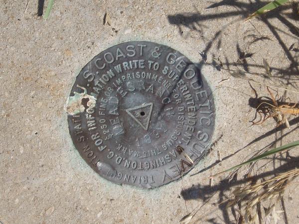
Every bench mark hunter and
land surveyor should know about this place. MEADES RANCH is
the NAD27 Geodetic Center of the nation, the "Primary Station" for
all surveys in the United States and in Mexico and Canada. With
generous permission from the owners, this event is for all who wish
to make the trek to the geodetic "Mecca" of the surveying world -
to Meades Ranch.
The Meades Ranch monument is
generally located 45 miles northeast of Hays, Kansas, and 60 miles
west-northwest of Salina, Kansas. Coordinates displayed on this
page are in degrees, minutes, and decimal minutes, the format
common to Geocaching.com.
The Meades Ranch monument is
on private land and is being made available to the public as a
courtesy for those reverently inspired by its significance to the
infrastructure of this continent. As a condition of being open to
the public, the owners have established some
guidelines.
- It is private agricultural land. As a
general policy, to prevent fire damage, no smoking will be
permitted on the premises.
- Each person will be charged 20
dollars cash for the use of the property. The Kansas Society
of Land Surveyors will NOT receive any proceeds from this
event. Children under 16 years old may participate for free.
The owners call this home and are not set up for swiping credit
cards, scanning checks, etc, therefore, cash is
preferred.
- Bring a sack lunch, something portable,
something that can be taken back with you when you're done with
it.
- This event is a "pack-it-in, pack-it-out"
idea. Please take all trash with you.
- Collecting a georock speciman is
allowed.
- Cameras and video recorders are
encouraged.
- Remember that this is a rustic site, so
restrooms are "available" if you can find a convenient bush that
you like.
- Rumor has it that the owners may have black
angus ranch beef burgers on the barbie up at the site.
- Rumor also has it that the owners may have
several horses for the event.
The Meeting Place, the South
Gate
N 39° 12.357' W 098°
32.486'
DRIVING DIRECTIONS to reach the Meeting
Place:
Follow the path through
Reference Points 1, 2 and 3 to get you to the Meeting
Place.
To get to Reference Point
#1, take U.S.281 north from Luray or south from Osborne, Kansas. At
about 12-15 miles either direction that you'll be coming there is a
County sign at Reference Point #1 that says: HUNTER, via county
road.
Reference Point #1:
N39° 11.472' W98° 41.666'
From Reference Point #1,
take the county road to the east. It is well marked as Osborne
County Road 412. Drive East for 4 miles on the good gravel road to
Reference Point #2 where the main pathway of the road will curve to
the left, to the north.
Reference Point #2:
N39° 11.502' W98° 37.215'
From Reference Point #2,
continue through the turn, taking you to the north. Drive north for
just one mile to Reference Point #3, where the main pathway of the
road will turn again, this time to the right, getting you to drive
easterly again.
Reference Point #3:
N39° 12.345' W98° 37.175'
From Reference Point #3,
continue through the curve of the road and drive east for 4.2 miles
to the Meeting Place.
Meeting Place: N39°
12.357' W98° 32.486'
The meeting place is a
pasture gate on the north side of the road (left side). This is the
south entrance to the private property where the Meades Ranch disk
resides.
Four-Wheel Drive Vehicles
The posted coordinates mark
the meeting place, the South Gate, where we will all gather
together. When we are ready, we'll make the trek up to The
Disk. The owners will provide rides into the land up to the
location of the Meades Ranch monument. Since this event is being
held as a cooperative effort, it would also be helpful if some
participants could bring four-wheel drive vehicles for support. If
you can bring a four-wheel drive vehicle, please mention it in a
"will attend" log.
The disk is over a mile from
the meeting place and is accessed from a twisty curvey rough trail
road. HOWEVER, attendees will get to ride (or drive) all the
way there to within just a few feet to level pasture ground. So the
terrain rating is pretty much insignificant for the short and easy
walking part.
 Sample of vintage photos from the
NOAA Photo Library:
Sample of vintage photos from the
NOAA Photo Library:


Lodging, Osborne County
Lodging information was
obtained from the
Osborne County Chamber of Commerce. Their
toll-free phone number is 1-866-346-2670. Their website lists 14
different places nearby to stay. Each of the listings shows a phone
number and some have email addresses, too. Here's the link to the
list of lodging locations:
Lodging in Osborne
County
To help out, here's a bit
more information about some of the locations. For a traditional
hotel/motel, there is the Camelot Inn Motel right in the
city of Osborne on the highway. At the end of the list is West
Lake Inn, on Highway 24, ten miles east of Osborne in the city
of Downs. For a bed-and-breakfast, The Loft Bed and
Breakfast is owned by an old couple and has a couple bedrooms.
The Riverbend Bed and Breakfast, 3 miles east of Osborne,
was described as being a really nice selection. Other
bed-and-breakfast stays are the Covert Creek Lodge;
Howell House Bed and Breakfast 10 miles east of Osborne; and
the Prairie Lodge Bed and Breakfast 20 miles south of
Osborne. The others on the list are hunting lodges.
The website also lists
local area lakes.
More Lodging, Russell County
Here is more lodging
information that is available from the Russell County website. The
city of Russell is on I-70 Exit 184 and on U.S. Hwy 281, being 25
miles south and 10 miles west of the posted coordinates. The city
of Gorham is one and a half miles north of the I-70 Exit 175 and on
Old U.S. Hwy 40, being 25 miles south and 20 miles west of the
posted coordinates. The city of Lucas is 14 miles southeast of the
posted coordinates, and Luray is 9 miles south of the posted
coordinates.
Additional links for additional
reading
Osborne County Chamber of
Commerce talks about Meades Ranch.
Another link by the Osborne
County Chamber of Commerce
What does Wikipedia have to say
about Meades Ranch?
What is NAD27, and what does it
have to do with Meades Ranch?
Geocaching.com listing for
KG0640 Meades Ranch
http://www.geocaching.com/mark/details.aspx?PID=KG0640
View original datasheet from
Geocaching.com
http://www.geocaching.com/mark/datasheet.aspx?PID=KG0640
View the OFFICIAL datasheet from NGS, the
National Geodetic Survey.
1. Then click on the one item listed so that you highlight
it.
2. Then click on the "Get Datasheets" button.
3. Scroll all the way to the bottom and read what organization
filed the last two official Recovery Notes; that's right "Recovery
Note by Geocaching".
(GC9064) Geodetic Center-as
close as you get.. by barondriver
GEODETIC CENTER OF THE
NATION - Kansas Historical Markers on
Waymarking.com
Bench Marks nearest to
Meades Ranch - information from Geocaching.com
Evie's personal webpage:
http://eviewrayartist.blogspot.com/.
Butterfield Overland
Dispatch Markers on Waymarking.com
MINGO, the oldest active
geocache in the WORLD!
A shortened version of the
link to this webpage: http://coord.info/GC1X9QD
Users of Geocaching.com may
login and view the archived listings of previous tours of Meades
Ranch: 2008, 2007.
This event is in
coordination with the
NSPS Geocaching Project.
 Thank you Kyle
Brant. Thank you Evie Wray.
Thank you Kyle
Brant. Thank you Evie Wray.
REMEMBER:
- Make the fair trade.
- Log your visit.
- Leave the site better than you found
it.
- Protect the environment —
always.
- Educate those around you.
- Find another cache!
Good luck, and may all your cache dreams
come true.
—cantuland