STRUB CANYON
MountainNinja´s Cache Nr. 93 (Earth Cache Nr. 7)

Die Unterscheidung zwischen Schluchten und Klammen geschieht in erster Linie aufgrund der Steilheit der begrenzenden Hänge. Während in Schluchten die Hänge nicht so steil bzw. überhängend ausgebildet sind und auch kein Fels anstehen muss, werden die Wände in Klammen meist von blankem Fels gebildet, der sich im Extremfall über der Talsohle fast schließen kann. Klammen sind eine Konsequenz aus starker Tiefenerosion bei geringer oder fehlender seitlicher Erosion.
Die 2,7 km lange Strubklamm ist die Klamm des Almbaches, der im Hintersee entspringt, durch das Wiestal fließt und bei Hallein die Salzach erreicht.
Die Strubklamm ist ein Naturdenkmal!
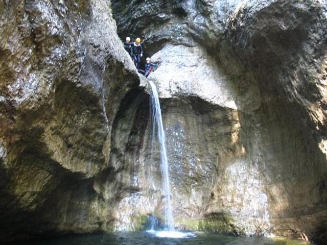
Die bis zu 200m hohen Felswände lassen manchmal nur eine spärliche Menge an Licht zu. Die Klamm ist im unteren Bereich manchmal nur bis zu 1m eng, im oberen breiter. Die Felswände fallen teilweise senkrecht ab. Der obere Teil, der sich auch bereits zu einem etwas weiteren Becken ausdehnt, ist mit dichter Buschwerkvegetation bewachsen und zeigt durchaus an manchen Stellen Urwaldcharakter. Dieser Teil ist daher auch ein bedeutendes Vogelbrutgebiet. Im Winter bildet die Klamm große Eisvorhänge, im Sommer ist sie ein beliebtes Canyoning- und Badegebiet.
Um diesen Earthcache loggen zu dürfen, MUSST Du durch die Klamm schwimmen!
Poste ein Foto von Dir in Canyonausrüstung direkt bei dem markanten Felsen
(Bergrettungspunkt Nr. 4) ! - Siehe Beispielbild!
Beantworte mir per mail wie hoch und breit die Klamm dort ungefähr ist.
Du brauchst meine Logerlaubnis nicht abwarten!

Primarily, the valley cross sections which are rather deep in proportion to her width are called gorges. The limitative slopes in the edges of a gorge are mostly very precipitous or can also overhang and a body of water is on the sole of a gorge mostly. Gorges are typical Steilschluchten which are to be found especially in the higher mountains.
The differentiation between gulches and gorges happens, primarily, on account of the steepness of the limitative slopes. While the slopes so precipitously or overhanging are not trained in gulches and also no cliff must be waiting, the walls are formed in gorges mostly by the shining cliff which can almost shut in the extreme case about the low. Gorges are a consequence from strong deep erosion with low or missing lateral erosion.
The 2.7 km long Strubklamm is the gorge of the alp brook which arises in the Hintersee by which Wiestal flows and reaches with Hallein the Salzach.
Strubklamm is a natural monument!
Up to 200 m high cliff walls sometimes admit only one scanty amount in light. The gorge is narrow in the lower area sometimes only up to 1 m, in the upper one broader. The cliff walls drop partly vertically. The upper part which already extends to a little other washbasin is covered with thick shrubbery vegetation and absolutely shows at some places primeval forest character. Hence, this part is also a significant bird brood area. In winter the gorge forms big ice curtains, in summer it is a popular area Canyoning and bath area.
To get credit and claim a "Find" for this EarthCache you MUST swim through the Strubklamm!
Post a picture of yourself/s with you at the rock!
(Bergrettungspunkt Nr. 4) and let us know how many people were in your party.
Tell us via email how high you estimate the gorge is at the position.
Dont wait for my logpermission!


|