
3-D Relief Map of the Philippines - Rizal Park - Manila, Philippines
Posted by:  silverquill
N 14° 35.062 E 120° 58.829
51P E 282433 N 1613322
This enormous 3-D map of the Philippines is located on the east boundary, along Taft Ave., of the sprawling Rizal Park. Designed by sculptor Jose M. Mendoza under the Marcos regime, it now sits in disrepair.
Waymark Code: WMG30C
Location: Philippines
Date Posted: 01/06/2013
Views: 8
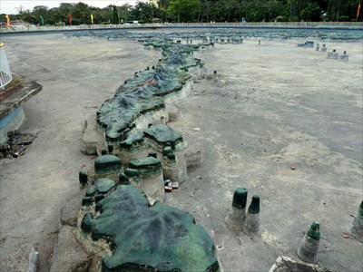
No exact dimensions are given for this monumental creation, but it probably covers several acres. Details about this work are sketchy. It was a project commissioned by Fredinand Marcos and his wife Imelda who was head of the National Parks Development Committee, so it the date of its construction had to be sometime in the twenty year period from late 1965 to early 1986.
A 2001 article in the Philippine Star has this to say about the sculptor and the creation of this unique work.
"His [Jose M. Mendoza] best-known work (more familiar to Filipinos than the artist himself) is the Giant Relief Map of the Philippines visible to harassed commuters breathing the carbon monoxide of jeepneys plying Taft Avenue. The million-peso project (a staggering budget at a time when the dollar was valued at three pesos) took him nine months to complete. As resident sculptor of the park, his works (Janus, Children? Playground, Garden for the Blind and Reliefs in Cement) are scattered all over the sprawling historical site."
Earlier photos show the site filled with water and the mountains and valleys of the Philippine Islands vividly painted, such as those of John Lander .
Photos as early as 2001, however, show it to be empty of water, and its current state in 2011 remains sadly dilapidated. Even so, the topography of the islands can be seen in accurate perspective, given a fascinating overview of the diversity of islands that make up this Pacific country.
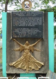
RELIEF MAP OF THE PHILIPPINES
HORIZONTAL SCALE 1:18 800
VERTICAL SCALE 1: 4,600
A PROJECT OF PRESIDENT FERDINAND E. MARCOS EXE
CUTED BY THE NATIONAL PARKS DEVELOPMENT COMMITTEE
HEADED BY MRS. IMELDA R. MARCOS WITH THE COOPE-
RATION AND ASSISTANCE OF THE BUREAU OF COAST AND
GEODETIC SURVEY, BUREAU OF PUBLIC HIGHWAYS. BUREAU
OF FORESTRY. PHILIPPINE AIRE FORCE, PHILIPPINE ARMY,
AND THE COMMISSION ON VOLANOLOGY.
JOSE M. MENDOZA . SCULPTOR
ISIDRO M. AUREADA ENGINEER IN-CHARGE
PONCIANO C. CICERON CARTOGRAPHIC ADVISER
ERNESTO GM. VILLAVICENCIO
A R C H I T E C T