This is the sort of walk you want to do if you are in the mood to do a bit of sweating and puffing although if you just take your time it is really a quite enjoyable climb/hike that has some excellent views on a good sunny day. The walk starts at the boat jetty at Lake Hauroko and standing on the jetty facing out if you look north (right) the dominant hill you see with the 'V' shaped slip is Oblong Hill. It will not be to this slip that the walk takes you but rather it will be to the left of it and down a bit. The walk is just a route that does not get a lot of use but is reasonably defined and when I climbed this I had no trouble sticking to the track itself. It is a walking distance of only 3.5 kms but has an elevation from Lake level of 428 metres to the lookout. All up it should take about 2 hrs to the lookout and this climb is not one I would at all recommend for young children or paraplegics. The walk, when you start, heads north around the lake edge through
Native Forest until soon enough you come to the point where the climbing begins. It does involve some steep climbing and has no safety rails or ropes but I think once you get up here the views are quite worth the effort. The lookout itself is nothing more than a rock ledge with no marker or indicators as such - you know when you are there just by the fact that the view opens up and you can't climb anymore. Would be a cool place to put a geocache if anyone had the inclination. The view from here you can see is looking left you are looking across to the Lillburn Valley. Straight down in front of you you will be able to make out the boat jetty and going right is First Bay then the peninsula, then over to Second Bay then over the large ridge you see partially the main body of the lake that goes south. Behind all that is views of the Rowallan Forest and the Hump Range. A camera is a fairly essential piece of equipment up here. Pick your day and only go when it is sunny - the weather here tends to be '
Fiordland Typical'. Also it would pay to be mindful of the fact that this place is frequented by
Deerstalkers
quite a bit and it wouldn't be unusual to come across one or two - more so at the start of the walk to the base of the hill. I wouldn't imagine you will see any
Hunters
on the climb up! Taking a
Topographical Map just to give you an idea of the gradient would also be wise to say the least.
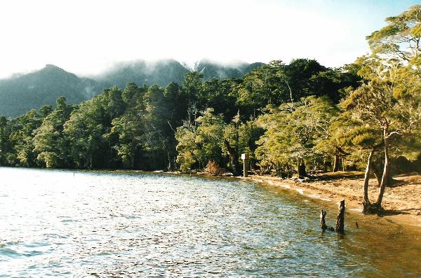
Picture.1.
Above view is taken from the Boat Jetty looking at the start of the walk around the lake shore with a cloud covered Oblong Hill behind. This is the mark of the posted coordinates.
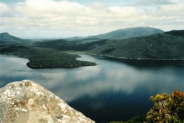
Picture .2.
This pic is from the lookout which is at approx coordinates of S45*58.542 E167*21.589. The view is looking at the peninsula between First and Second Bay. At the very back left of the pic is a partial view of the Helmut Hill and back far right of the pic is the Hump Range.In the distance can be seen Te WaeWae Bay.
 Compass & Topographical Map Suggested / Required Compass & Topographical Map Suggested / Required |
 Steep Hike Steep Hike
|
 Some Climbing (No special equipment required) Some Climbing (No special equipment required)
|
 Wear Insect Repellant! Wear Insect Repellant! |
 Weather Permitting Weather Permitting |
 Scenic View - Bring A Camera Scenic View - Bring A Camera |
 No Dogs Allowed No Dogs Allowed |
 Approx 2 Hrs Hiking required to top Approx 2 Hrs Hiking required to top |
 Hunters often in the area Hunters often in the area |