
Berwick, ME
Posted by:  silverquill
N 43° 16.012 W 070° 51.897
19T E 348648 N 4792139
Berwick lies on the south bank of the Salmon Falls River which separates it from Somersworth, New Hampshire. Berwick was one of the earliest settlements in the state, dating from as early as 1631 when it was part of Kittery.
Waymark Code: WMBJJ1
Location: Maine, United States
Date Posted: 05/26/2011
Views: 3
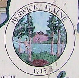
This welcome sign is located near the town Hall for Berwick, Maine. It is in the outline shape of the state of Maine and features the town seal.
"The Berwick Town Seal was adopted for use during Berwick’s 250th Anniversary celebrations of 1963. The seal was designed by Miss Jean Wilcox, an art major at the University of New Hampshire, at that time.
In the immediate foreground is the tall pine trees for which Pine Hill was named. According to legend, these magnificent trees were among the first things seen as one approached our community. Standing under the pines is an Indian Grave representing the earliest settlers of this community. In the background on the river bank is a saw mill representing the earliest industry of the Town. This mill is reported to be the first in this country and was located on or near the Salmon Falls River in the old Township of Newichawannock, now the Great Works section of South Berwick." Town of Berwick