Crotched Mountain Summit Trail - Francestown, NH
Posted by:  Telomere
N 43° 00.121 W 071° 51.710
19T E 266737 N 4765013
A former downhill ski run, now a 4x4 trail...!
Waymark Code: WM764D
Location: New Hampshire, United States
Date Posted: 09/07/2009
Views: 4
From Route 47: Take Mountain Road (or Back Mountain Road) to East Road. As you go up East Road, the "Condominiums at Mountain 1" will be on your right - continue past that, you will see an old ski lift stanchion and the surface turns to gravel. Just before the first house (on left), this access road will begin on the right.
Coordinates above mark this spot, and can be considered accurate - I logged them with the GPSr. The entire section of the mountain used to be part of Crotched Mountain Ski Area, and this trail used to be one of the ski runs! Check the satellite photo to see the overgrown trails and the straight cuts where the chairlift used to be.
The first stage is nothing more than a one-lane gravel road, but the vertical quickly kicks in, and the surface turns to tire-chewing crushed basalt chunks. Once you are headed up, the trail has a couple of tight turns, and numerous water bars, some shallow, some deep. The lower half can be done in 4H, but the last segment is very steep, and should be done in 4L. Nothing here requires extreme ground clearance - my TJ did it with 31's at stock height. Traction can be sketchy so MT tires are necessary.
At the top, you will see wooden steps (more of the old ski area) and a fenced in cell site. There is a spot here to accomplish a 3-point turn to get pointed back down. Before leaving, park here and take the steps up to the top, and hike just over the ridge to the west overlook...the view of everything from Powder Mill Pond to Mt. Monadnock is worth the time.
NOTE also: The signs that appear in 2 places on the approach to the trail say "Private Road - residents and guests only", but these are artifacts. When the ski area went through bankruptcy and closed in 1989, these were all tranferred to public roads.
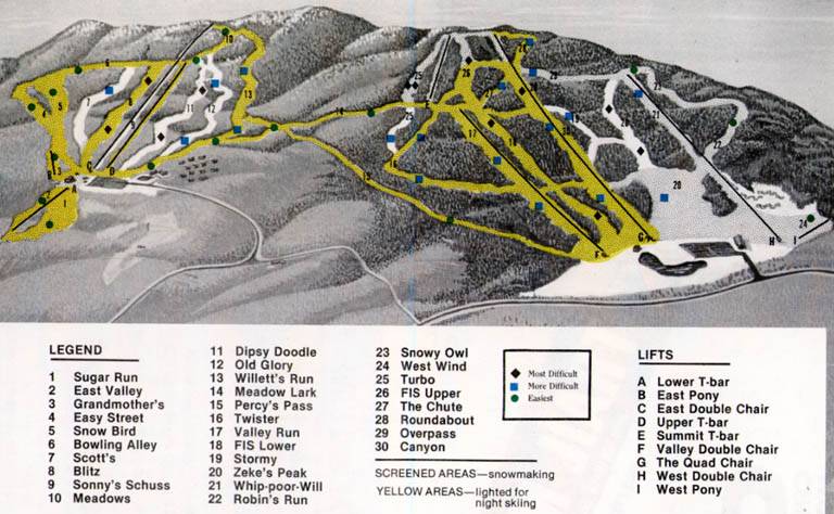
This trail is the S-shaped run at the extreme left on this 1989 map: