Desprendimiento sobre el Jarama
Posted by:  monticola
N 40° 22.420 W 003° 30.810
30T E 456407 N 4469358
Un desprendimiento de bloques obliga al río Jarama a describir un pequeño meandro. A fall of rock blocks forced the river Jarama to describe a small meander.
Waymark Code: WM6MGJ
Location: Comunidad de Madrid, Spain
Date Posted: 06/21/2009
Views: 10
Una serie de fallas de traza nordeste-suroeste dan origen, en esta zona, a un pronunciado escarpe que alcanza desniveles de alrededor de cien metros entre el llano superior, donde se ubican las áreas urbanas de Rivas Vaciamadrid, y la llanura aluvial del río Jarama.
A series of failures of northeast-southwest trace in this area a steep escarpment slopes reaching about one hundred meters from the flat top, where they are located in urban areas Rivas Vaciamadrid and the floodplain of the river Jarama.
Por otra parte, parece que cierto basculamiento general de la meseta hacia el suroeste condiciona la tendencia del río a desplazarse en esa dirección aproximándose al escarpe, cuya base socava. Esto hace que el valle del río en esta zona sea muy asimétrico. Mientras se adosa a aquel escarpe por su margen derecha, la margen izquierda muestra una topografía más convencional: una amplia llanura de inundación y una sucesión de terrazas.
It also seems that a tilting of the plateau southwest of the river affects the tendency to move in that direction approaching the escarpment which undermines base. This makes the valley of the river in this zone is very asymmetrical. While attached to that escarpment on his right, the left shows a more conventional situation: with a broad flood plain and a series of terraces.
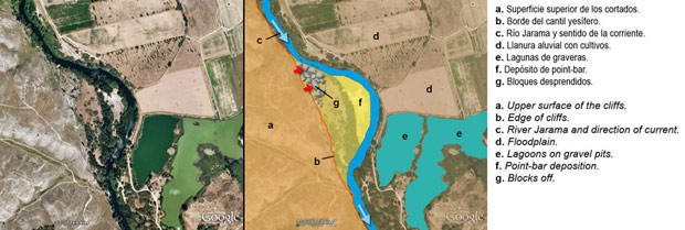
A continuación se muestra una interpretación sobre la imagen de Google Earth (puedes verla en un tamaño mayor desde la galería). Below is a interpretation on a Google Earth image (You can see it in a larger size from the gallery):
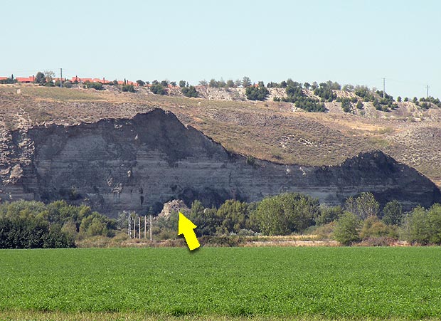
Desde la llanura del río se aprecia tanto el frente del escarpe, con una serie de pequeños valles colgados (con sus propios depósitos aluviales), como alguno de los grandes bloques caídos (señalado por la flecha). From the plain of the river is seen as the front of the escarpment, with a series of hanging valleys (with its own alluvial deposits), as one of the large fallen blocks (indicated by arrow):