Pecos River High Bridge
Posted by: Groundspeak Regular Member linkys
N 29° 42.653 W 101° 21.220
14R E 272306 N 3289068
Highest highway bridge in the State of Texas.
Waymark Code: WM3E8F
Location: Texas, United States
Date Posted: 03/22/2008
Published By:Groundspeak Regular Member GEO*Trailblazer 1
Views: 113

This spandrel braced (cantilever) arch bridge in West Texas is on Highway 90, which traces the route of the historic Old Spanish Trail and is located a short distance upstream from where the intersection of the Pecos River meets the Rio Grande, a place made famous by the infamous Judge Roy Bean, "The only law west of the Pecos."

A Texas Historical Marker on the east side of the bridge provides the following information: High canyon walls dominate the last 60 miles of the Pecos River before it enters the Rio Grande. The Southern Pacific Railroad built the first highway bridge to span the river was built one mile down river from here in 1923. Just 50 feet above water, the 1923 bridge was destroyed by floodwaters in 1954. Two temporary low water bridges built nearby in 1954 and 1955 also were destroyed by floodwaters. A new 1,310-feet long bridge was completed here in 1957. At 273-feet above the river it is the highest highway bridge in Texas.

2008 and 2009 will find something new for the 50 year old span, a complete rehabilitation at a cost of $4.2 million. The work will involve removing the walkways and increasing the traffic lanes by four feet. That will mean increased safety for drivers using the bridge, but at the expense of being able to walk out on it. No longer will the No Diving and No Fishing signs be needed.

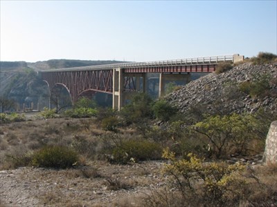
View of the complete span taken from down on the old roadbed on the west side of the span.

Complete span

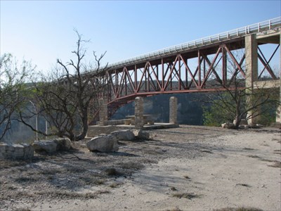
Prior to this bridge being built in 1957, the road leading down to where the 1923 bridge spanned the river ran right under the west side. The new bridge was built right over this old road and a picnic area. The view looking south down the old roadbed under the new bridge. It must have been some sight to have traveled on this road while the new bridge was being constructed.

Under

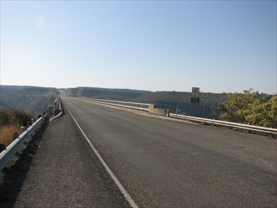
Current roadway looking west to east.

Roadway
Length of bridge: 1310 ft

Height of bridge: 273 ft

What type of traffic does this bridge support?: Motor vehicles

What kind of gap does this bridge cross?:
Pecos River


Date constructed: Cmpleted April 1959

Is the bridge still in service for its original purpose?: Yes

Name of road or trail the bridge services: Rt 90

Location:
Between Langtry and Del Rio on Rt 90, Val Verde County, Texas (50 miles west of Del Rio)


Visit Instructions:
Please submit a photo(s) taken by you of your visit to the location (non-copyrighted photos only). GPS photos are also accepted with the location in the background, and old vacation photos are accepted. If you are not able to provide a photo, then please describe your visit or give a story about the visit. If the bridge location prevents you from taking a safe photograph, then please do not stop to take the photo. Safety is more important.
Search for...
Geocaching.com Google Map
Google Maps
MapQuest
Bing Maps
Nearest Waymarks
Nearest Arch Bridges
Nearest Geocaches
Create a scavenger hunt using this waymark as the center point
Recent Visits/Logs:
Date Logged Log User Rating  
Sneakin Deacon visited Pecos River High Bridge 03/26/2018 Sneakin Deacon visited it
Six Little Spookies visited Pecos River High Bridge 06/03/2017 Six Little Spookies visited it
WalksfarTX visited Pecos River High Bridge 09/01/2016 WalksfarTX visited it
Benchmark Blasterz visited Pecos River High Bridge 07/22/2015 Benchmark Blasterz visited it
jackrock visited Pecos River High Bridge 11/09/2011 jackrock visited it
WTT-B2 visited Pecos River High Bridge 01/11/2009 WTT-B2 visited it

View all visits/logs