
Pico Blanco Register
Posted by:  Touchstone
N 36° 19.120 W 121° 48.705
10S E 606663 N 4019949
The summit register atop Pinco Blanco was placed by the nearby Pico Blanco Boy Scout Camp. Apparently, the Scout Camp runs hikes to the summit during the middle of the night. Sounds like quite the adventure, but you may want to do it during the day.
Waymark Code: WM3B5
Location: California, United States
Date Posted: 11/03/2005
Views: 79
The summit register is rather unique to summit registers. It is a 3-4
inch piece of galvanized pipe that is cemented to the summit. Although it
is a fairly arduous hike, when I was up there the register was already on its
third logbook.
Besides the wonderful views from the summit, you can also log the following:
Benchmark: GU3767
Geocache: Genesis
(GCR3R2)
Trail Info:
There are two ways to approach the summit. Both are
arduous, difficult, hikes. The first involves a rather substantial amount
of elevation gain, the second is a bit more brushy.
Bottchers Gap Approach:
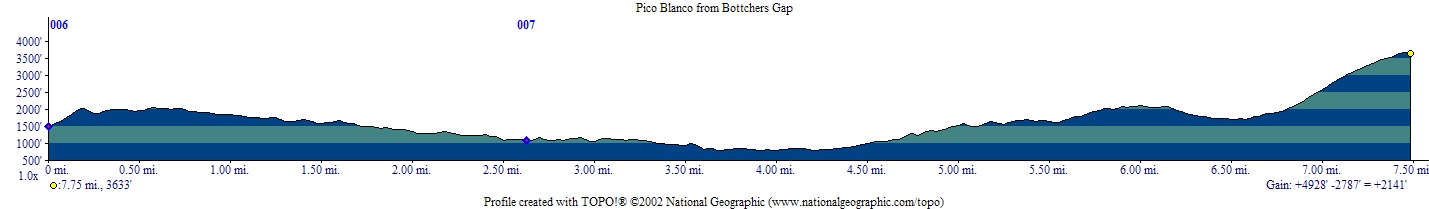
Mileage: ~15 miles round trip
Elevation: ~5,000 feet
Trailhead Coordinates: N36 21.240 W121 48.829
Trail Log: From Hwy 1, a turnoff for Palo Colorado Canyon leads
to Bottchers Gap (turnoff is at N36 23.958 W121 54.279). Bottchers Gap is
at the end of the road. There is a parking fee at the trailhead ($5.00 at
the time of this listing). The lot is patrolled so pay the fee. From
the parking area, look for a well marked dirt road with a gate to the South.
This road leads down to the Pico Blanco Boy Scout Camp. After dropping
1,200 feet in about three miles you will reach the Scout Camp. The route
through the Scout Camp is well marked and you shouldn't have any problems
finding your way. A trail junction will be reached soon after leaving the
Scout Camp. The left branch heads down the river, while the right branch
heads up towards Pico Blanco. A 1,000 foot climb will bring you to the
crest of Launtz Ridge where you will intersect the Mount Manual Trail. Take the
trail to the right and descend approximately 500 feet past an abandoned logging
operation before making the gradual climb towards the Southeast flank of Pico
Blanco. A large meadow will be encountered eventually and keep an eye out
for the "general use" trail that leads to the summit (approximately
N36 18.784 W121 48.180). A climb of approximately 2,000 feet in one mile
(pretty much straight up) will get you to the summit.
Little Sur River Trail Approach:
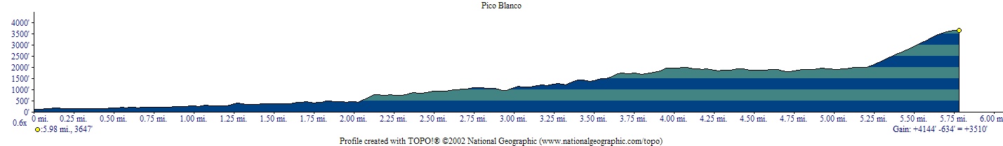
Mileage: ~12 miles round trip
Elevation: ~3,500 ft.
Trailhead Coordinates: (approx.) N 36 19.556 W121 51.578
Trail Log: Take the Old Coast Road (starts at Bixby Creek
Bridge on the N end, and Andrew Molera S.P. on the S end) to the Little Sur
River crossing. Just South of the double bridge crossing over the
river (about the 6 mile marker), the road will start climbing. The first
gate will be a nice new green metal gate. The second one will be a
homemade barbed wire "ranch" fence. Find parking off the road at
the "ranch" fence; this is your trailhead.
The trail follows an old logging road for a couple of miles to a
river crossing. I encountered many downed trees, but all were passable.
The trail climbs steeply beyond the river crossing and eventually crosses the
old road that heads up towards the summit. DO NOT follow this road.
It is marked as a private ranch road. The trail is well marked and goes
directly across. The trail deteriorates shortly beyond this point, and
although there is a trail, it is sadly overgrown. It will be a struggle
for a couple of miles as you push your way through the brush. The trail is
easy to follow, but it's not easy going. Eventually you'll get to an
unmarked trail junction. Down is to the Pico Blanco Backcountry Camp, and
up goes towards the summit and the Boy Scout Camp beyond.
A mile or so beyond the trail junction, there will be a fairly
obvious trail junction with a path heading pretty much straight up to the
summit. The climb from this point up is approximately 2,000 feet. It
is a general use trail, so don't expect any switchbacks. Enjoy the summit
:)