|
 Chesapeake Bay Impact Crater
N 37° 16.016 W 076° 01.400
18S E 409266 N 4124975
This impact crater is located in Chesapeake Bay area. The coords. are for the Chesapeake Bay Impact Crater sign. These are also the coords. for an earthcache. The sign has some missing information so the answers to the earthcache are not revealed.
Waymark Code: WM26BD
Location: Virginia, United States
Date Posted: 09/11/2007
Views: 244
What is a Bolide?
Probably the most dramatic geological event that ever took place on the Atlantic margin of North America occurred about 35 million years ago in the late part of the Eocene Epoch. This was a time when sea level was unusually high everywhere on Earth. The ancient shoreline of the Virginia region was somewhere in the vicinity of where Richmond is today. The late Eocene climate was even warmer and more humid than today's tidewater summers. Tropical rain forests covered the slopes of the Appalachians, and a broad, lime-covered continental shelf stretched to the east of a narrow coastal plain. But with a brief flash of mind-numbing light, that tranquil scene was transformed into a bloody killing field of incredible carnage. From the far reaches of the solar system, a giant bolide swooped through the Earth's atmosphere. It blasted an enormous crater into the continental shelf, and obliterated nearby terrestrial flora and fauna.
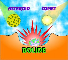
What is a bolide? There is no consensus on its definition, but we use it to mean an extraterrestrial body in the 1-10-km size range, which impacts the earth at velocities of literally faster than a speeding bullet (20-70 km/sec = Mach 75), explodes upon impact, and creates a large crater. "Bolide" is a generic term, used to imply that we do not know the precise nature of the impacting body . . . whether it is a rocky or metallic asteroid, or an icy comet, for example.
Simple vs. Complex Impact Craters
Nearly everyone knows what an impact crater looks like. For most, that image is derived from Meteor Crater (also known as Barringer Crater) in Arizona, some 38 miles east of Flagstaff, the archetypical example of what cratering experts call a simple crater.
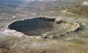
It is a shallow, bowl-shaped excavation, 1 km in diameter, with an upraised sub-circular rim, and is extraordinarily well-preserved. Meteor Crater was the first terrestrial crater recognized as an impact structure back in the 1920's. Since then, more than 150 additional impact craters have been identified.
Few of you probably know that most craters wider than 10 km are classified as complex craters, because they exhibit additional features. A good example of a complex crater is King Crater on the farside of the moon.
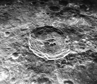
Like simple craters, the outer margin of complex craters is marked by a raised rim. Inside the rim is a broad, flat, circular plain, called the annular trough. Large slump blocks fall away from the crater's outer wall and slide out over the floor of the annular trough toward the crater center. The inner edge of the annular trough is marked by either a central mountainous peak, a ring of peaks (a peak ring), or both. Inside the peak ring is the deepest part of the crater, called the inner basin. The Chesapeake Bay crater has all the characteristics of a peak-ring crater, like King crater.
Location of Chesapeake Bay
Did the Chesapeake Bay bolide affect the location of Chesapeake Bay itself? The answer is a complicated one. We know that the bay is nowhere near 35 million years old, which is when the bolide struck. In fact, as late as 18,000 years ago, the bay region was dry land; the last great ice sheet was at its maximum over North America, and sea level was ~200 m lower than at present. This exposed the yellow area shown in the figure, which now is the bay bottom and continental shelf.
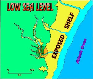
With sea level this low, the major east coast rivers had to cut narrow valleys across the region all the way to the shelf edge, where they dumped their sediment loads into deep water. About 10,000 years ago, however, the ice sheets began to melt rapidly, causing sea level to rise and flood the shelf and the coastal river valleys. The flooded valleys became the major modern estuaries, like Delaware Bay and Chesapeake Bay. But notice that the rivers of the Chesapeake region converged at a location directly over the buried crater. Is that merely coincidence? Let's look at some field data.
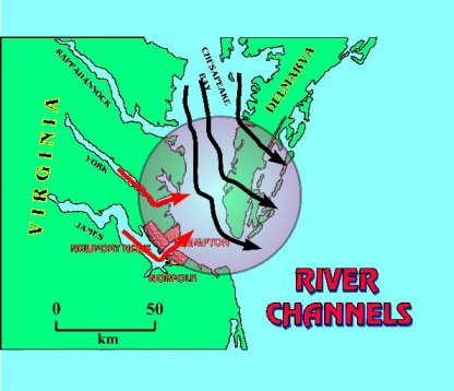
Here is a map showing the location of three successive buried ice-age channels of the ancient Susquehanna River (formed from 450,000 years ago to 20,000 years ago). Note that each channel changes course significantly just after it crosses the rim of the buried crater. This river diversion, combined with seismic evidence that the post impact units sag and thicken over the crater, indicates that the ground surface over the crater remained lower than the areas outside the crater for 35 million years. Why should it do that?
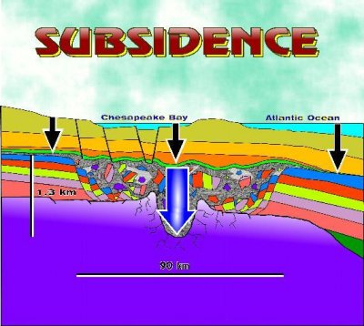
The two sets of different-colored arrows in this figure represent different components of subsidence of the land surface. The black arrows represent subsidence due to loading during the past 35 million years since the impact. The blue arrow represents subsidence due to compaction of the breccia. Remember that the breccia is 1.2 km thick, and was deposited as a water-saturated, sandy, rubble-bearing slurry (like a Jello fruit salad before it jells). The sediment layers surrounding it were already partly consolidated, so the mushy breccia would compact much more rapidly under its subsequent sediment load than the surrounding strata. This produced a subsidence differential, causing the land surface over the breccia to remain lower than the land surface outside the crater. Therefore, the river valleys converged over the crater and were located in those particular places when rising sea level flooded them. In short, the impact crater created a long-lasting topographic depression, which helped predetermine the eventual location of Chesapeake Bay.
Summary
During the late Eocene, the formerly quiescent geological regime of the Virginia Coastal Plain was dramatically transformed when a bolide struck in the vicinity of the Delmarva Peninsula, and produced the following principal consequences:
*The bolide carved a roughly circular crater twice the size of the state of Rhode Island (~6400 km2), and nearly as deep as the Grand Canyon (1.3 km deep).
*The excavation truncated all existing ground water aquifers in the impact area by gouging ~4300 km3 of rock from the upper lithosphere, including Proterozoic and Paleozoic crystalline basement rocks and Middle Jurassic to upper Eocene sedimentary rocks.
*A structural and topographic low formed over the crater.
*The impact crater may have predetermined the present-day location of Chesapeake Bay.
*A porous breccia lens, 600-1200 m thick, replaced local aquifers, resulting in ground water ~1.5 times saltier than normal sea water.
*Long-term differential compaction and subsidence of the breccia lens spawned extensive fault systems in the area, which are potential hazards for local population centers in the Chesapeake Bay area.
(All text for this waymark was copied from the USGS website.)
For more information about this crater, visit the website listed below.
Type of Crater: Complex

Crater Diameter: 90.27 km
Age of Crater: 35,000,000.00
Crater Web Page: [Web Link]
View from the Coordinates:
Chesapeake Bay and Cape Charles
|
Visit Instructions:
1. An original photograph of your visit must be supplied with your log. Invalid
logs will be deleted.
2. The waymark owner may have specific logging requirements
|