
Ames Monument
Posted by:  NevaP
NevaP
N 41° 07.869 W 105° 23.878
13T E 466596 N 4553392
This massive pyramid of granite stands largely forgotten on the high plains of southeastern Wyoming.
Waymark Code: WM1KCP
Location: Wyoming, United States
Date Posted: 05/26/2007
Views: 179
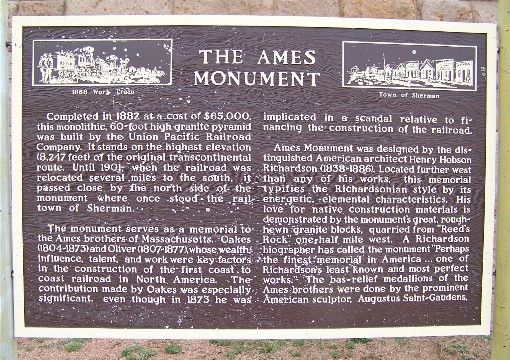
The magnificent Ames Monument, a massive granite pyramid, sixty feet square at the base and sixty feet high, stands in lonely splendor on the Wyoming high plains less than two miles from busy I-80 but ignored by most travelers. It was constructed in 1882, at a cost of $65,000. At that time it stood next to the tracks of the Union Pacific Railroad, on a knoll, which at 8,247 feet, was the highest point on the line.
The monument honors the Ames brothers, Oakes (1804-1873), a U.S. Congressman and Oliver (1807-1877), the third president of the Union Pacific Railroad. These wealthy and influential Massachusetts natives made significant contributions to the building of the first transcontinental railroad. Oakes, however was later involved in corruption scandals related to the finances of the railroad construction.
The pyramid was designed by Henry Hobson Richardson, a prominent American architect, and bas-relief busts of the Ames brothers, near the top of the monument, were added by Augustus Saint-Gaudens, an important American sculptor. As he did in many of his buildings, Richardson used local materials and most of the light pink colored granite blocks forming the pyramid were quarried half a mile away. The type of construction used for the monument is known as “random ashlar,” which means rough-hewn, irregular sized granite blocks (“ashlar”) jointed in a random manner.
In 1901 the railroad route was relocated several miles to the south and the monument was no longer visible from passing trains. The original route of the Lincoln highway, established in 1913, followed the old railroad grade and again passed close to the monument but the highway was rerouted in 1920 leaving the memorial to the Ames brothers again alone and nearly forgotten in the Wyoming sagebrush. It was placed on the National Register of Historic Places 7/24/1972.
The monument is reached from exit 329 on I-80. Bear left on the gravel roads south of the highway and follow your GPS. It’s less than two miles to the monument and you will see it from some distance away.
This information plaque stands at the monument:
Visit Instructions:When visiting the location, please try to take a picture with your GPSr if you are alone, or with members of your party in the shot. Also, please describe your visit/adventures so others will know what to expect when they get there.