|
 The Bannock War of 1878 - Park County, WY Posted by:  T0SHEA T0SHEA
N 44° 52.574 W 109° 07.691
12T E 647845 N 4970905
Along Highway 120 north of Cody, about 9.5 miles south of the Montana border is a pullout with a pair of Wyoming Historical Markers. This marker tells of the Bannock War, a part of which took place nearby.
Waymark Code: WM15QT6
Location: Wyoming, United States
Date Posted: 02/11/2022
Views: 0
The Bannock War of 1878, caused solely by starvation on the reservation, the result of the government's not following through on promises of food, was one of two, the second occurring in 1895. The 1895 uprising turned out to be "much ado about nothing" as there was no real uprising, eastern newspapers having printed hugely exaggerated stories of the events around Jackson's Hole, WY.
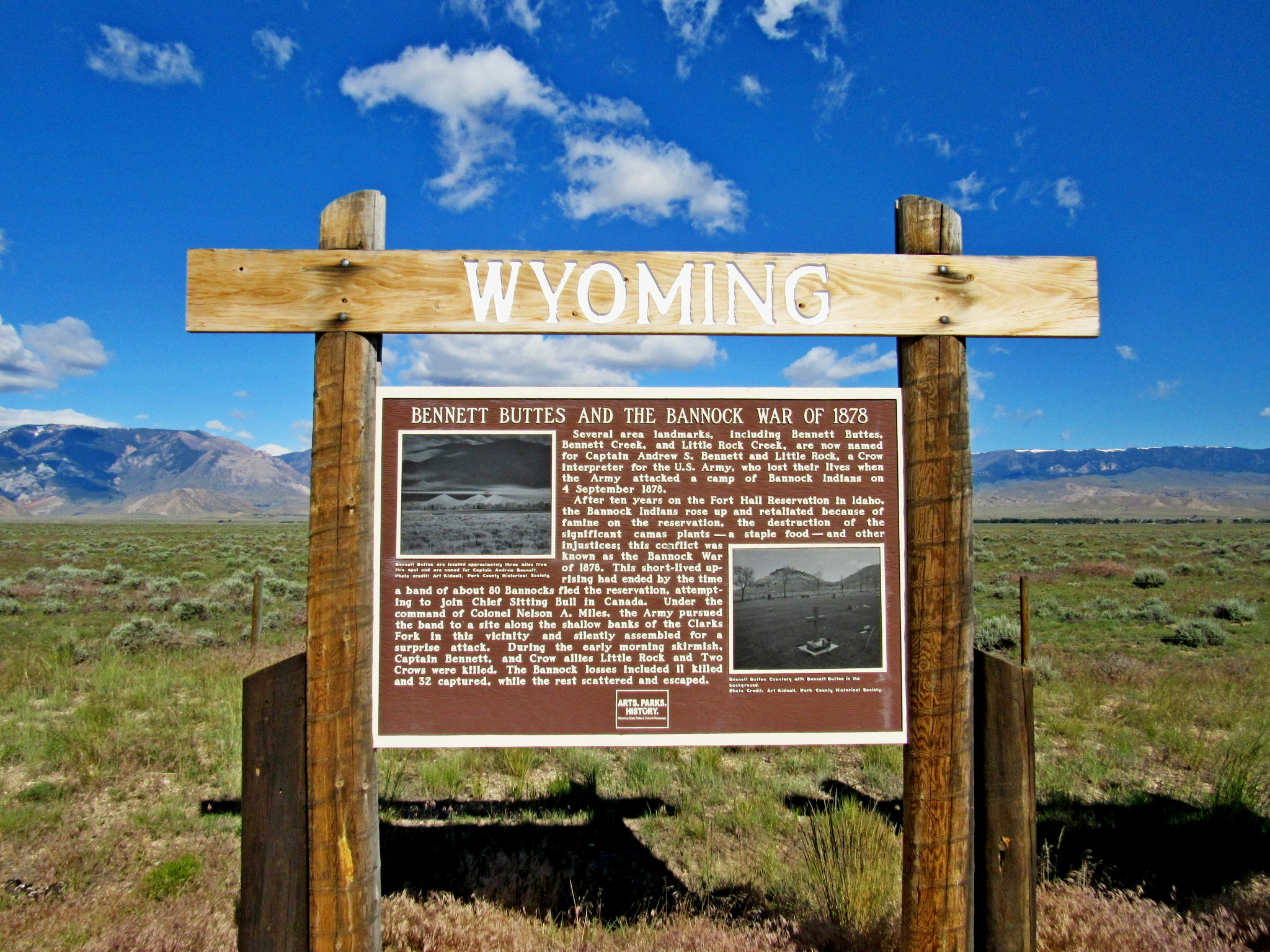
BENNETT BUTTES AND THE BANNOCK
WAR OF 1878
Several area landmarks, including Bennett Buttes, Bennett Creek, and Little Rock Creek, are now named for Captain Andrew S. Bennett and Little Rock, a Crow interpreter for the U.S. Army, who lost their lives when the Army attacked a camp of Bannock Indians on 4 September 1878. After ten years on the Fort Hall Reservation in Idaho, the Bannock Indians rose up and retaliated because of famine on the reservation, the destruction of the significant camas plants — a staple food — and other injustices; this conflict was known as the Bannock War of 1878.
This short-lived up-rising had ended by the time a band of about 80 Bannocks fled the reservation, attempting to join Chief Sitting Bull in Canada. Under the command of Colonel Nelson A. Miles, the Army pursued the band to a site along the shallow banks of the Clarks Fork in this vicinity and silently assembled for a surprise attack. During the early morning skirmish, Captain Bennett, and Crow allies Little Rock and Two Crows were killed. The Bannock losses included 11 killed and 32 captured, while the rest scattered and escaped.
From the Wyoming Historical Highway Marker
 The History of the Wyoming Historical Highway Markers
Wyoming boasts one of the oldest monuments and markers program in the nation. At a time when few thought to mark history, interested and concerned residents of Wyoming realized the need to commemorate the past. These people placed monuments and markers that served to preserve a piece of the state’s heritage.
While the creation of the Wyoming Historical Landmarks Commission formally established a markers program in 1927, marking historic points actually began more than fifty years earlier. In 1875, the Union Pacific Railroad Company erected the Ames Monument, a 60-foot stone monument located at the original summit of the transcontinental railroad. The monument memorializes Oakes and Oliver Ames, brothers from Massachusetts, whose wealth and influence played an important role in the construction of the Union Pacific line through Wyoming.
The Union Pacific may have been the first to place a marker in Wyoming, but it was Ezra Meeker, an Oregon Trail veteran, who built support for marking important pieces of that great westward highway. Ezra Meeker was born in Huntsville, Ohio in 1830 and traveled over the Oregon Trail in 1852 with his wife. Meeker felt that the Oregon Trail was a “symbol of the heroism, the patriotism, the vision, and the sacrifices of the pioneers who had won the West for America.”
Twenty-two monuments and markers existed along the Trail when Meeker began a campaign to mark points in March 1906. By 1908, Meeker had succeeded in either directly or indirectly erecting 150 monuments. Inspired by Meeker’s actions, the Oregon Trail Memorial Association formed. Meeker served as the Association’s first president and helped to promote the Memorial Coin Bill. This bill authorized the creation and sale of Oregon Trail Memorial Fifty-Cent Pieces. The proceeds went to funding new signs. When Meeker died in 1928, the Association carried on his passion and vision for marking sites along the Trail.
The Daughters of the American Revolution (DAR) began marking historic places in 1908 and is responsible for many of the markers seen today.
Name of Battle:
Clarks Fork Battle

Name of War: Bannock War of 1878
Entrance Fee: 0.00 (listed in local currency)
Date(s) of Battle (Beginning): 09/04/1878
Parking: Not Listed
Date of Battle (End): Not listed
|
Visit Instructions:
Post a photo of you in front of a sign or marker posted at the site of the battle (or some other way to indicate you have personally visited the site.
In addition it is encouraged to take a few photos of the surrounding area and interesting features at the site.
Recent Visits/Logs:
| There are no logs for this waymark yet. |
|
|
|
|