 [TB] Vértice Geodésico ANÃO
| Trackable Options |
 Found this item? Log in.
 |
 Printable information sheet to attach to [TB] Vértice Geodésico ANÃO
Print Info Sheet
Printable information sheet to attach to [TB] Vértice Geodésico ANÃO
Print Info Sheet |
| There are 3 users watching this listing. |
-
Owner:
-
meninosousa
Message this owner
-
Released:
-
Wednesday, April 14, 2010
-
Origin:
-
Lisboa, Portugal
-
Recently Spotted:
-
Unknown Location
This is not collectible.
Use TB29MCQ to reference this item.
First time logging a Trackable? Click here.

VÉRTICE GEODÉSICO ANÃO
Visitar o máximo número possível de vértices geodésicos de Portugal.
ATENÇÃO: Se econtrar uma versão anterior deste trackable, por favor entre em contacto comigo. Muito obrigado.

VÉRTICE GEODÉSICO ANÃO
Visit the maximum possible number of triangulation stations in Portugal.
WARNING: If you find a previous version of this trackable please contact me. Thank you.
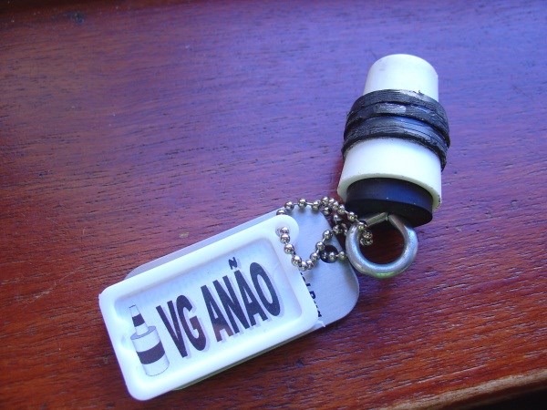
VÉRTICE GEODÉSICO ANÃO
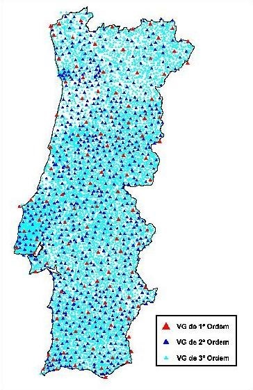
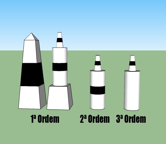
A Rede Geodésica Nacional é composta por cerca de 9 000 vértices geodésicos (também conhecidos por “talefes”) no continente (cujo centro está em Vila de Rei, no Centro Geodésico de Portugal), 351 no Arquipélago dos Açores e 108 no Arquipélago da Madeira, agrupados em 3 ordens:
• A rede de 1ª ordem tem 126 pilares com distâncias compreendidas entre 40 a 60 Km. Estes pilares foram construídos e observados pela 1ª vez no século XIX.
• A rede de 2ª ordem tem cerca de 900 pilares com distâncias compreendidas entre 20 e 40 Km.
• A rede de 3ª ordem contém os restantes pilares com distâncias compreendidas entre 5 e 10 Km (havendo em média um vértice por cada 10 km2).
Os Vértices são bons para que queira experimentar colocar uma cache pois normalmente o acesso não é muito mau e costumam de proporcionar uma boa vista.
VÉRTICE GEODÉSICO ANÃO
The Portuguese National Geodetic Network comprises around 9 000 triangulation stations (also known as “talefes” here in Portugal) in the mainland (where it’s center is located in Vila de Rei at the Portuguese Geodetic Center), 351 in the Azorean Archipelago and 108 in the Madeira Archipelago, divided in 3 categories:
• The first order network comprises 126 stations with distances between them ranging from 40 to 60 Km. these stations were built and used for the first time in the XIX century.
• The second order network comprises around 900 stations with distances between them ranging from 20 to 40 Km.
• The third order network comprises the remaining stations with distances between them ranging from 5 to 10 Km (1 station for each 10 square meters average).
The stations are a good way to start the experience of placing a cace because they are away of the civilization and provide some great views.
Gallery Images related to [TB] Vértice Geodésico ANÃO
View All 11 Gallery Images
Tracking History (20666.9mi) View Map