
Conquered by
the Roman troops in the end of the first century B.C., the the
current territory of Trás-os-Montes region will have been the
target of a strong reclassification process where the previous
fortified towns would been romanized or abandoned, self-sufficiency
yielded to a market economy based on the use of currency, in the
intensification of farming and exploration of the mining wealth
creating a , new social, religious and political order which will
not have gone unoticed.
 An intense road network was
created in this region that created a main thoroughfare that
connected Bracara Augusta (Braga), Asturica
Augusta (Astorga) to Aquae Flaviae (Chaves),
orientated in a general East-West direction totaling 396
km.
An intense road network was
created in this region that created a main thoroughfare that
connected Bracara Augusta (Braga), Asturica
Augusta (Astorga) to Aquae Flaviae (Chaves),
orientated in a general East-West direction totaling 396
km.
Its tracing
covers the Portuguese councils of Braga, Póvoa de Lanhoso, Vieira
do Minho, Montalegre, Boticas, Chaves, Valpaços, Mirandela, Macedo
de Cavaleiros, Vinhais and Bragança, entering in Spanish territory
near Zamora (Villardeciervos, Santibánez, Rosinos de Vidriales and
Camarza de Tera) until Astorga, passing still in the leonese
community of Castrocalbón.
This roadway
was integrated within a vast communication network , served by
intermediate support stations to travellers - mansiones,
mutationes, stationes - that would allow to connect any point
of the Empire to the Roman capital, giving rise to the popular
saying: All roads lead to Rome.
Conquistado pelas tropas
romanas nos finais do séc. I a.C., o território da actual região
transmontana terá sido alvo de um processo de reordenamento em que
os anteriores povoados fortificados foram romanizados ou
abandonados, a auto-suficiência deu lugar a uma economia de mercado
baseada no uso da moeda, na intensificação agro-pecuária e
exploração da riqueza mineira, ao qual não terá sido alheia uma
nova ordem social, política e religiosa.
Foi criada uma intensa rede
viária, cujo eixo principal, nesta região, era a via que ligava
Bracara Augusta (Braga) a Asturica Augusta
(Astorga) por Aquae Flaviae (Chaves), tomando o sentido
geral este-oeste, num total de 396 kilometros, ao longo da qual
existiram dezenas de miliários. O seu traçado percorre os actuais
concelhos portugueses de Braga, Póvoa de Lanhoso, Vieira do Minho,
Montalegre, Boticas, Chaves, Valpaços, Mirandela, Macedo de
Cavaleiros, Vinhais e Bragança, entrando em território espanhol por
terras de Zamora (Villardeciervos, Santibánez, Rosinos de Vidriales
e Camarza de Tera) até Astorga, passando ainda pela comunidade
leonesa de Castrocalbón.
Esta via integrava uma
vasta rede de comunicações, servida por estações interme diárias
de apoio aos viajantes – mansiones, mutationes, stationes
– que permitiria ligar qualquer ponto do Império à
capital romana, justificando-se assim o ditado popular: "Todos
os caminhos vão dar a Roma".
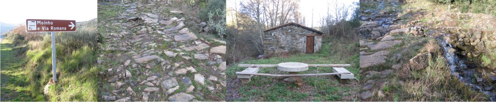
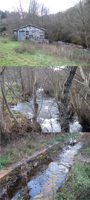
The
cache:
The
coordinates of this cache will take you to a spot on the left
margin of the Alimonde River between Alimonde and Carrazedo. The
access to the cache must be made on foot although, you can drive
down to the river in a 4x4 (I strongly suggest you leave your 2x4
near the tarred road, especially in winter). Near the cache site,
you will be able to view the stream, two old stone houses, one of
which is a mill. You will be able to see the way the river has been
diverted to drive the mill wheels.
The cache
itself is located above the Roman roadway and affords ample view of
it. I don't know if you will be able to retrieve the cache if it
snows so be aware of the weather. Enjoy it!
______________________________________________________________________________